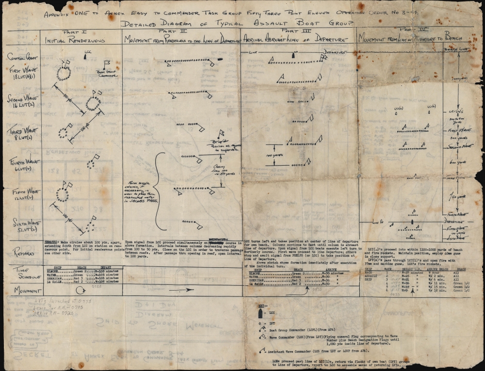
Digital Image: 1944 Bellerby Map of U.S. Marine Landing on Roi-Namur, Kwalajein Atoll, Marshall Isla
ShiptoShoreRoiNamur-bellerby-1944_d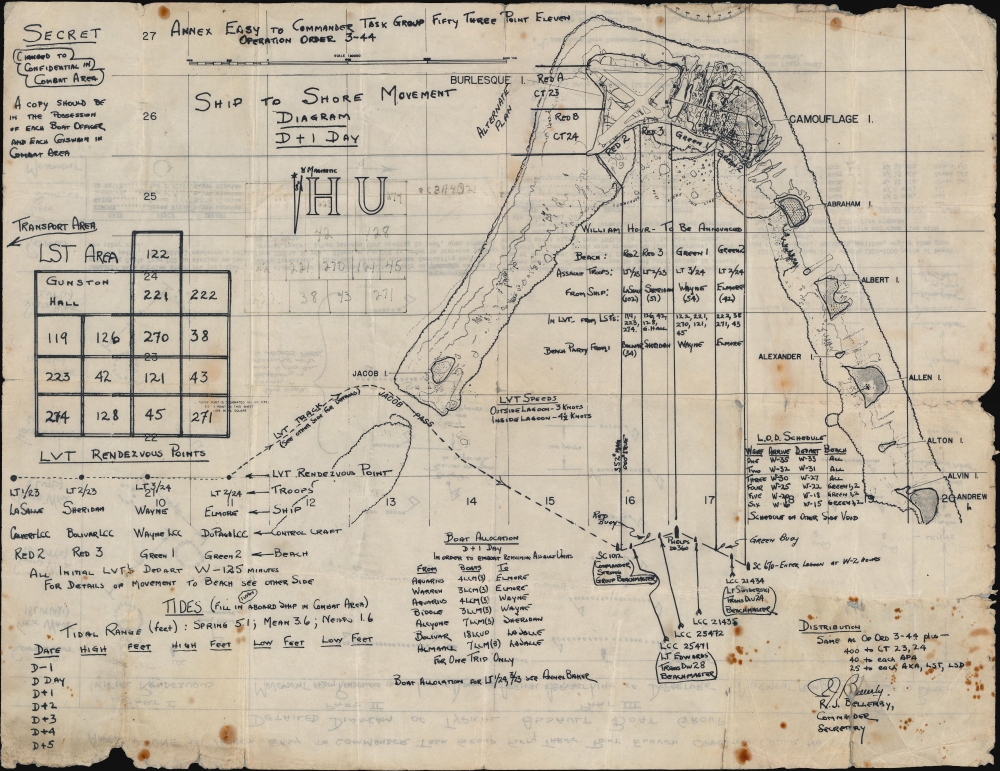

Description
FOR THE ORIGINAL ANTIQUE MAP, WITH HISTORICAL ANALYSIS, CLICK HERE.
Digital Map Information
Geographicus maintains an archive of high-resolution rare map scans. We scan our maps at 300 DPI or higher, with newer images being 600 DPI, (either TIFF or JPEG, depending on when the scan was done) which is most cases in suitable for enlargement and printing.
Delivery
Once you purchase our digital scan service, you will receive a download link via email - usually within seconds. Digital orders are delivered as ZIP files, an industry standard file compression protocol that any computer should be able to unpack. Some of our files are very large, and can take some time to download. Most files are saved into your computer's 'Downloads' folder. All delivery is electronic. No physical product is shipped.
Credit and Scope of Use
You can use your digial image any way you want! Our digital images are unrestricted by copyright and can be used, modified, and published freely. The textual description that accompanies the original antique map is not included in the sale of digital images and remains protected by copyright. That said, we put significant care and effort into scanning and editing these maps, and we’d appreciate a credit when possible. Should you wish to credit us, please use the following credit line:
Courtesy of Geographicus Rare Antique Maps (https://www.geographicus.com).
How Large Can I Print?
In general, at 300 DPI, you should at least be able to double the size of the actual image, more so with our 600 DPI images. So, if the original was 10 x 12 inches, you can print at 20 x 24 inches, without quality loss. If your display requirements can accommodate some loss in image quality, you can make it even larger. That being said, no quality of scan will allow you to blow up at 10 x 12 inch map to wall size without significant quality loss. For more information, it is best consult a printer or reprographics specialist.
Refunds
If the high resolution image you ordered is unavailable, we will fully refund your purchase. Otherwise, digital images scans are a service, not a tangible product, and cannot be returned or refunded once the download link is used.
Cartographer
Russell John Bellerby (July 8, 1902 - July 2, 1985) was an American military officer. Born in Dawson, Yukon Territory, Canada, he graduated from high school in 1920 in Fairbanks, Alaska, and then entered the U.S. Naval Academy, the first appointee to the Naval Academy from central Alaska. In June 1924 he graduated from the Naval Academy and was commissioned as an Ensign. He served in various sea and shore postings throughout the 1920s and 1930s and became the Executive Officer of the U.S.S. Zeilin, an attack transport, in late 1940. He held this position until shortly after November 11, 1942, when the Zeilin was hit by a bomb from a Japanese plane. The Zeilin managed to return to the United States and was repaired. Bellerby was transferred to serve on the staff of various Transport commands and participated in the landings at Attu in the Aleutian Islands, Kwajalein, Peleliu, Guam, and Samar. In early 1945 he was transferred back to the United States and served as Fleet Support Officer of Los Angeles Naval Base for all of 1945. In 1946 he assumed command of the U.S.S. Pitt and participated in the first post-war amphibious training exercises in the Pacific, conducted jointly with the Sixth Army. He became the Commanding Officer of the Tsingtao unit, Joint U.S. Military Advisory Group to the Republic of China in early 1947. He remained in the Navy at least through the Korean War, if not longer, and retired as a Rear Admiral. More by this mapmaker...