This item has been sold, but you can get on the Waitlist to be notified if another example becomes available, or purchase a digital scan.
1944 Bellerby Map of U.S. Marine Landing on Roi-Namur, Kwalajein Atoll, Marshall Islands
ShiptoShoreRoiNamur-bellerby-1944$1,500.00

Title
Annex Easy to Commander Task Group Fifty Three Point Eleven Operation Order 3-44. Ship to Shore Diagram D + 1 Day. / Appendix One to Annex Easy to Commander Task Group Fifty Three Point Eleven Operation Order No 3-44. Detailed Diagram of Typical Assault Boat Group.
1944 (undated) 17 x 22 in (43.18 x 55.88 cm)
1944 (undated) 17 x 22 in (43.18 x 55.88 cm)
Description
An exceptional discovery, this is a 1944 Ship-to-Shore diagram map of the landings on Roi and Namur in Kwajalein Atoll in the Marshall Islands. It is possibly the first printed ship-to-shore diagram issued by the U.S. military - and is certainly the earliest known. Such diagrams were introduced during World War II when amphibious assault doctrine was initially developed. The only other known World War II ship-to-shore diagrams relate to subsequent operations, among them the June 6, 1944, D-Day landings and the invasion of Iwo Jima.
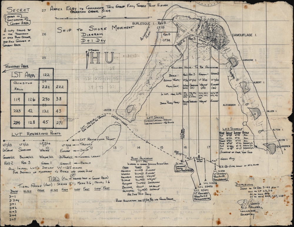
A Closer Look: Ship-to-Shore Movement Diagram D+1 Day
The Ship-to-Shore diagram is dominated by a detailed map of the northern part of Kwajalein Atoll. Roi (BURLESQUE) and Namur (CAMOUFLAGE) are the northernmost islands in the atoll, with ABRAHAM, ALBERT, ALLEN, ALEXANDER, ALTON, ALVIN, and ANDREW (U.S. military code names) to the right (east) and JACOB to the left (west). Airfields appear on Roi, and buildings are illustrated on Namur. The landing beaches (RED 2, RED 3, GREEN 1, and GREEN 2) are labeled. A reef just off the beach is marked by a dashed line.The Annotations
The map is historically significant, marking the invasion beaches and detailing landing strategies. In the lagoon just below Roi and Namur, a table assigns troop units to each of the four invasion beaches at 'William Hour.' Farther down, at the bottom of the beach diagram, beachmasters and specific vessels (including the Phelps, which was in charge of the landings) are identified. To the right, specific speeds are provided for the amtracs (LVTs - tracked amphibious vehicles). A schedule to the right of the beach diagram provides arrival and departure times for the first six waves of Marines to hit the beaches. To the left, a table presents boat allocations to specific vessels, and a second table details the specific actions of the transports LaSalle, Sheridan, Wayne, and Elmore. A notation in the upper right marks the map as 'Secret' and that the status 'Changed to Confidential in Combat Area.' It also notes, 'A copy should be in the possession of each Boat Officer and each Coxswain in Combat Area.'A Closer Look: Detailed Diagram of Typical Assault Boat Group
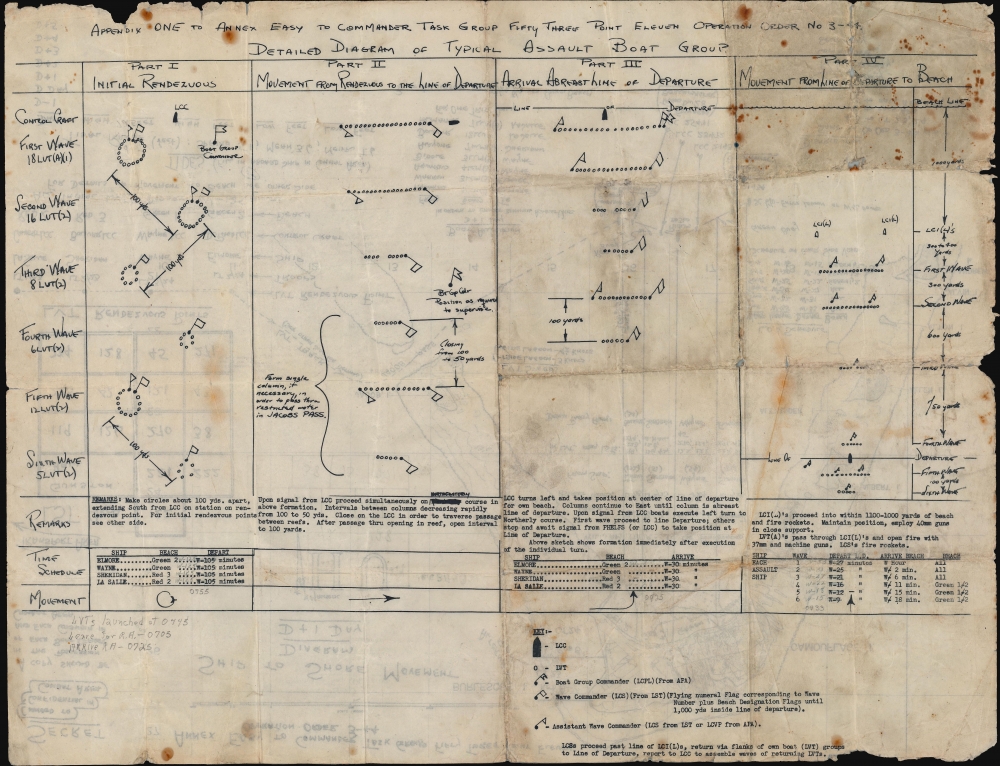
A Detailed Diagram of Typical Assault Boat Group occupies the verso. This diagram details the formations used by each of the first six waves from the 'Initial Rendezvous' through the 'Movement from Rendezvous to the Line of Departure' to the 'Arrival Abreast Line of Departure,' and the 'Movement from Line of Departure to Beach.' Distances between waves are marked, including distances between the circles of transports in the rendezvous area (100 yards). Remarks below provide more detail with illustrations showing how transports are to proceed at each point. Hand-written annotations note changes to scheduled movements since the printed time schedule was incorrect.The Landings on Roi-Namur
On February 1, 1944, a day after the landings on Ivan, Jacob, Albert, Allen, and Abraham (code names for smaller islands to the south of Roi and Namur in the atoll), Marines from the 23rd and 24th Regimental Combat Teams assaulted beaches on Roi and Namur, respectively. Marines landed in amtracs (LVTs) and hastily gathered Higgins boats (LCVPs) when it became apparent that enough LVTs would not be available. Roi was almost entirely secured that first day, with only 'mopping up' remaining the next day. On Namur, the fighting lasted until the afternoon of February 2. Between February 2 and February 7, Marines occupied 55 islands in the northern half of Kwajalein Atoll. The entire operation in the northern half of the atoll took two and a half days, and the 4th Marine Division suffered 737 casualties, including 190 either killed in action or that subsequently died of their wounds. The Japanese suffered 3,472 killed and 51 taken prisoner.Ship-to-Shore Movement Diagrams
Ship-to-Shore Movement Diagrams detail how an amphibious landing force will deploy from amphibious transports. Such diagrams were first developed during World War II. None are cataloged with consistency. The only other ship-to-shore diagrams we have found relate to the D-Day Normandy Invasion and the invasion of Iwo Jima. It is unclear if ship-to-shore diagrams were used in the landings on Guadalcanal or Tarawa, which predate the invasion of Kwajalein in the Pacific, or the Operation Torch landings in North Africa. Thus it is possible that this diagram represents the first use of a ship-to-shore diagram, now an essential aspect of American amphibious assault doctrine.Distribution
In the lower right corner of the recto, a note details the diagram's distribution. It states that distribution will be 'same as Op Ord 3 - 44 plus - 400 to CT (Combat Team) 23, 24; 40 to each APA (Auxiliary Personnel, Attack); and 25 to each AKA (Attack Cargo Ships), LSTs (Landing Ship, Tank), and LSDs (Landing Ship, Dock).' Unfortunately, we do not know the exact distribution of Op Ord 3 - 44, distributed on January 5, 1944.Publication History and Census
This map was approved (and possibly drawn) by Russell J. Bellerby in 1944. This is the only known surviving example.Cartographer
Russell John Bellerby (July 8, 1902 - July 2, 1985) was an American military officer. Born in Dawson, Yukon Territory, Canada, he graduated from high school in 1920 in Fairbanks, Alaska, and then entered the U.S. Naval Academy, the first appointee to the Naval Academy from central Alaska. In June 1924 he graduated from the Naval Academy and was commissioned as an Ensign. He served in various sea and shore postings throughout the 1920s and 1930s and became the Executive Officer of the U.S.S. Zeilin, an attack transport, in late 1940. He held this position until shortly after November 11, 1942, when the Zeilin was hit by a bomb from a Japanese plane. The Zeilin managed to return to the United States and was repaired. Bellerby was transferred to serve on the staff of various Transport commands and participated in the landings at Attu in the Aleutian Islands, Kwajalein, Peleliu, Guam, and Samar. In early 1945 he was transferred back to the United States and served as Fleet Support Officer of Los Angeles Naval Base for all of 1945. In 1946 he assumed command of the U.S.S. Pitt and participated in the first post-war amphibious training exercises in the Pacific, conducted jointly with the Sixth Army. He became the Commanding Officer of the Tsingtao unit, Joint U.S. Military Advisory Group to the Republic of China in early 1947. He remained in the Navy at least through the Korean War, if not longer, and retired as a Rear Admiral. More by this mapmaker...
Condition
Fair. Wear along original fold lines. Tattered edges. Some soiling. Some slight loss. No repairs done due to content on both sides.