1753 Hanway / Gibson Map of Central Siberia
Siberia-gibson-1753$400.00

Title
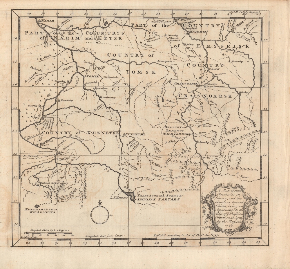
A map of some provinces in Siberia, and the borders towards China : being an appendage to the map of Russian Frontiers, as surveyed by the Russians, 1747.
1753 (dated) 9.5 x 10 in (24.13 x 25.4 cm) 1 : 5000000
1753 (dated) 9.5 x 10 in (24.13 x 25.4 cm) 1 : 5000000
Description
A wonderfully detailed map of a central portion of Siberia around Tomsk, engraved by John Gibson and published in 1753 in Jonas Hanway's An Historical Account of the British Trade over the Caspian Sea. With Russia's presence being established in the area in the early 17h century, the map reflects the steadily growing presence of Russian soldiers, missionaries, and settlers by the mid-18th century.
As can be seen, though most of this part of the Russian Empire was sparsely populated by nomadic peoples, Russian towns, villages, missions, and forts had sprung up in some density by the mid-18th century, especially along rivers, which were the main means of transportation.
A Closer Look
Covering a central portion of southern Siberia, this map takes in several 'countries' (governorates, губерния), the most important at that time being Tomsk, located near the confluence of the Ob and Tom Rivers. Other nearby important settlements include the fort (ostrog) of Kuznetsk (now Kemerovo), Crasnoarsk (Krasnoyarsk), and Enyseisk (Yeniseysk). Aside from the Ob and Tom Rivers, the River Enyseisk (Yenisei) and Lake Teleuscoe (Teletskoye) were important landmarks in the region. The boundary of 'Chinese Tartary' - that is, Mongolia - seen at bottom-right, was loosely defined by the Treaty of Kyakhta (1727). Fairly atypically, longitude is measured from Cazan (Kazan) rather than St. Petersburg, as would be standard on later maps.As can be seen, though most of this part of the Russian Empire was sparsely populated by nomadic peoples, Russian towns, villages, missions, and forts had sprung up in some density by the mid-18th century, especially along rivers, which were the main means of transportation.
Publication History and Census
The map was engraved by John Gibson in 1753 for inclusion in Jonas Hanway's An Historical Account of the British Trade over the Caspian Sea. Aside from his extensive travels in Russia, as suggested in the title, Hanway also benefitted from access to Russian maps during his time in St. Petersburg (see biography below). This map is independently cataloged among the holdings of Harvard University, the Buffalo and Erie County Public Library, Louisiana State University, the University of Illinois Urbana-Champaign Spurlock Museum of World Cultures, and the National Library of Scotland.CartographerS
Jonas Hanway (August 12, 1712 - September 5, 1786), was an English philanthropist, traveller, and writer. He was apprenticed in 1729 to a merchant in Lisbon, but in 1743 he became partner to merchant and member of the British Russia Company Robert Dingley (1710 - 1780) who was based in St. Petersburg. This led to the travels in Russia, Central Asia, and Persia which would inform Hanway's (copious) writing on the topic of British trade in the Caspian Sea, which would earn him the attentions of scholar Charles Wilson who hailed him 'one of the most indefatigable and splendid bores of English history.' On his return to London his narrative brought him some fame and success, and thereafter he remained in the city devoted to good causes and good citizenship. He founded The Marine Society in 1756 (a charity supporting inland youths wishing to go to sea.) He was instrumental in the aid of various hospitals; arranged improvements in Londons's birth registration system; and in 1762 he was appointed a commissioner for victualling the navy. Hanway was an eccentric and a gadfly. He protested, voluminously, the English practice of tea drinking, both on the grounds of its effect on the health and on the balance of foreign trade. He was the first male Londoner to carry an umbrella. This shocking move drew the opprobrium of fellow Londoners who objected to the effeminate, French contraption, and the ire of hansom cab drivers who quite correctly identified the invention as a threat to their trade (rainstorms caused Londoners to flock to hansom cabs as a sheltered means of transport.) He died unmarried. A monument to his memory stands in Westminster Abbey, praising his works of charity. It discusses neither umbrellas nor tea. More by this mapmaker...
John Gibson (1724 – 1773) was an English map engraver active in London at the end of the 18th century. Gibson was the son of a locksmith. In 1739 he apprenticed to John Blundell as a stationer of Grub Street. Gibson proved a fine engraver and was much in demand by London map publishers. During his career he produced thousands of maps and was admired as a skilled engraver and sculptor. Among others, he engraved for Emanuel Bowen, Robert Sayer, Jean Palairet, John Rocque, Andrew Dury, and Benjamin Martin. His best known work was prepared in conjunction with Gentleman's Magazine. Gibson, sadly, was not as astute in his fiscal affairs as with the engravers pen and consequently spent much of his life consigned to debtor's prison. Learn More...
Source
Hanway, J., An Historical Account of the British Trade over the Caspian Sea, (London: Mr. Dodsley) 1753.
Condition
Very good. Some creasing in the right margin and offsetting throughout.
References
OCLC 41569873, 1334116722.