Digital Image: 1909 Peterson Promotional Real Estate Map of South Dakota
SouthDakota-peterson-1909_d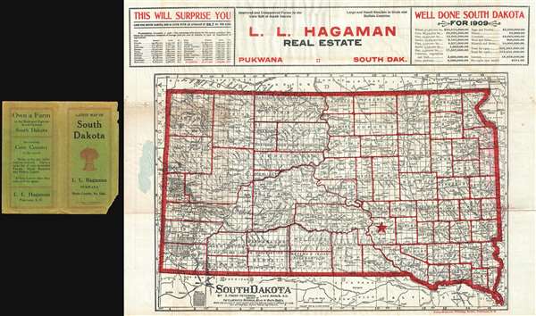

Title
South Dakota. / L. L. Hagaman Real Estate Pukawa South Dak.
1909 (dated) 17 x 22 in (43.18 x 55.88 cm) 1 : 1340000
1909 (dated) 17 x 22 in (43.18 x 55.88 cm) 1 : 1340000
Description
FOR THE ORIGINAL ANTIQUE MAP, WITH HISTORICAL ANALYSIS, CLICK HERE.
Digital Map Information
Geographicus maintains an archive of high-resolution rare map scans. We scan our maps at 300 DPI or higher, with newer images being 600 DPI, (either TIFF or JPEG, depending on when the scan was done) which is most cases in suitable for enlargement and printing.
Delivery
Once you purchase our digital scan service, you will receive a download link via email - usually within seconds. Digital orders are delivered as ZIP files, an industry standard file compression protocol that any computer should be able to unpack. Some of our files are very large, and can take some time to download. Most files are saved into your computer's 'Downloads' folder. All delivery is electronic. No physical product is shipped.
Credit and Scope of Use
You can use your digial image any way you want! Our digital images are unrestricted by copyright and can be used, modified, and published freely. The textual description that accompanies the original antique map is not included in the sale of digital images and remains protected by copyright. That said, we put significant care and effort into scanning and editing these maps, and we’d appreciate a credit when possible. Should you wish to credit us, please use the following credit line:
Courtesy of Geographicus Rare Antique Maps (https://www.geographicus.com).
How Large Can I Print?
In general, at 300 DPI, you should at least be able to double the size of the actual image, more so with our 600 DPI images. So, if the original was 10 x 12 inches, you can print at 20 x 24 inches, without quality loss. If your display requirements can accommodate some loss in image quality, you can make it even larger. That being said, no quality of scan will allow you to blow up at 10 x 12 inch map to wall size without significant quality loss. For more information, it is best consult a printer or reprographics specialist.
Refunds
If the high resolution image you ordered is unavailable, we will fully refund your purchase. Otherwise, digital images scans are a service, not a tangible product, and cannot be returned or refunded once the download link is used.
Cartographer
Eric Frank Peterson (1862 - c. 1939) was an American cartographer and homesteader active in South Dakota and Dakota Territory in the late 19th and early 20th centuries. Peterson was born in Minnesota but moved with his family to Dalesburgh, Clay County, Dakota, in 1878. In 1882 he and his family homesteaded in Charles Mix County, Dakota. At this time, he attended University at Vermillion. In 1884, he was elected Clay County Superintendent of Schools, a position that he held for 4 years. Around 1882, Peterson began working in cartography to supplement his income as a school teacher. He published several South Dakota state and county atlases as well as city plans, thematic maps, and regional maps. He also began studying law and was admitted to South Dakota Bar in 1899. His heath began to suffer in the early 20th century and in 1908 he relocated to Florida, from which he continued to publish and license his Dakota maps and even issue d a few maps of Florida. A year later in 1909, he moved again, this time to California, where he remained until at least 1939. More by this mapmaker...