This item has been sold, but you can get on the Waitlist to be notified if another example becomes available, or purchase a digital scan.
1540 Münster / Ptolemy Map of Southeast Asia (1540 first issue)
Southeastasia-munster-1540$425.00

Title
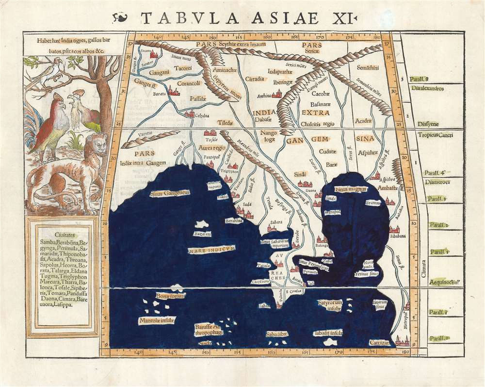
Tabulas Asiae XI.
1540 (undated) 10.5 x 13.25 in (26.67 x 33.655 cm) 1 : 21500000
1540 (undated) 10.5 x 13.25 in (26.67 x 33.655 cm) 1 : 21500000
Description
This is a 1540, first edition first state example of Sebastian Münster's Ptolemaic map of Southeast Asia and the Malay Peninsula. The region was known to ancient geographers as 'India Extra Gangem,' or 'India Beyond the Ganges.'
A Closer Look
The map thus embraces Thailand, Burma, and Vietnam, reaching from the tip of the Malay Peninsula to the Himalayas in the north. The river Ganges is clearly shown and named. The region of Aurea chersonensis (the Malay Peninsula, possibly inclusive of Sumatra) and Aurea Regio (Burma) speak to the allure the region held to European armchair explorers (Aurea = Golden.). The map portrays two bodies of water, both with an array of named islands: the Indian Ocean (Mare Indicum) and the Sinus Magnus (the Great Bay). Beyond the Great Bay to the east is another coastline: this, according to Ptolemy's geography, was China.Cartographic Context
Ptolemy considered the Indian Ocean to be an inland sea, with the southern part of Africa continuing eastward to meet China beyond the Malay peninsula. The Sinus Magnus was the body of water enclosed by Malay Peninsula and the landmass encircling the whole of the Indian Ocean. Certainly, the modern maps included in Münster's edition of Ptolemy showed that he well understood that such a 'land bridge' between Africa and China did not exist. Geographia, however, was firstly a definitive edition of an ancient geographical text, and so Münster's sixteenth-century maps shared a binding with maps like this one, which reflected second-century geographical knowledge. Münster was not the only late Renaissance geographer to publish Ptolemy's work: the ancient maps in this edition were largely derived from the editions printed by Martin Waldseemüller in 1513, and those printed in Ulm in 1482 and 1486. The contemporary maps that accompanied them, however, were groundbreaking. The number of 'firsts' that appeared in Münster is impressive; and at least four editions of his Ptolemy were published before his death. Many of the maps in it were reprised in his masterwork, the Cosmographia, but the Ptolemaic area maps were not among them. Consequently, they are scarcer than many of Münster's other maps.A Decorative Work
Of the various editions of Ptolemy's eleventh Asia map, Münster's is the most decorative, thanks to the animals pictured in the upper left: a lion, a parrot, and what is almost certainly the earliest acquirable printed depiction of a cassowary.Publication History and Census
This map was prepared for inclusion in Münster's 1540 edition of Ptolemy's Geographia. This example conforms typographically to the 1540 first edition - making it exceptionally scarce. Seven examples of the separate map are cataloged in OCLC, and in its various editions, it appears on the market from time to time.CartographerS
Sebastian Münster (January 20, 1488 - May 26, 1552), was a German cartographer, cosmographer, Hebrew scholar and humanist. He was born at Ingelheim near Mainz, the son of Andreas Munster. He completed his studies at the Eberhard-Karls-Universität Tübingen in 1518, after which he was appointed to the University of Basel in 1527. As Professor of Hebrew, he edited the Hebrew Bible, accompanied by a Latin translation. In 1540 he published a Latin edition of Ptolemy's Geographia, which presented the ancient cartographer's 2nd century geographical data supplemented systematically with maps of the modern world. This was followed by what can be considered his principal work, the Cosmographia. First issued in 1544, this was the earliest German description of the modern world. It would become the go-to book for any literate layperson who wished to know about anywhere that was further than a day's journey from home. In preparation for his work on Cosmographia, Münster reached out to humanists around Europe and especially within the Holy Roman Empire, enlisting colleagues to provide him with up-to-date maps and views of their countries and cities, with the result that the book contains a disproportionate number of maps providing the first modern depictions of the areas they depict. Münster, as a religious man, was not producing a travel guide. Just as his work in ancient languages was intended to provide his students with as direct a connection as possible to scriptural revelation, his object in producing Cosmographia was to provide the reader with a description of all of creation: a further means of gaining revelation. The book, unsurprisingly, proved popular and was reissued in numerous editions and languages including Latin, French, Italian, and Czech. The last German edition was published in 1628, long after Münster's death of the plague in 1552. Cosmographia was one of the most successful and popular books of the 16th century, passing through 24 editions between 1544 and 1628. This success was due in part to its fascinating woodcuts (some by Hans Holbein the Younger, Urs Graf, Hans Rudolph Manuel Deutsch, and David Kandel). Münster's work was highly influential in reviving classical geography in 16th century Europe, and providing the intellectual foundations for the production of later compilations of cartographic work, such as Ortelius' Theatrum Orbis Terrarum Münster's output includes a small format 1536 map of Europe; the 1532 Grynaeus map of the world is also attributed to him. His non-geographical output includes Dictionarium trilingue in Latin, Greek, and Hebrew, and his 1537 Hebrew Gospel of Matthew. Most of Munster's work was published by his stepson, Heinrich Petri (Henricus Petrus), and his son Sebastian Henric Petri. More by this mapmaker...
Claudius Ptolemy (83 - 161 AD) is considered to be the father of cartography. A native of Alexandria living at the height of the Roman Empire, Ptolemy was renowned as a student of Astronomy and Geography. His work as an astronomer, as published in his Almagest, held considerable influence over western thought until Isaac Newton. His cartographic influence remains to this day. Ptolemy was the first to introduce projection techniques and to publish an atlas, the Geographiae. Ptolemy based his geographical and historical information on the "Geographiae" of Strabo, the cartographic materials assembled by Marinus of Tyre, and contemporary accounts provided by the many traders and navigators passing through Alexandria. Ptolemy's Geographiae was a groundbreaking achievement far in advance of any known pre-existent cartography, not for any accuracy in its data, but in his method. His projection of a conic portion of the globe on a grid, and his meticulous tabulation of the known cities and geographical features of his world, allowed scholars for the first time to produce a mathematical model of the world's surface. In this, Ptolemy's work provided the foundation for all mapmaking to follow. His errors in the estimation of the size of the globe (more than twenty percent too small) resulted in Columbus's fateful expedition to India in 1492.
Ptolemy's text was lost to Western Europe in the middle ages, but survived in the Arab world and was passed along to the Greek world. Although the original text almost certainly did not include maps, the instructions contained in the text of Ptolemy's Geographiae allowed the execution of such maps. When vellum and paper books became available, manuscript examples of Ptolemy began to include maps. The earliest known manuscript Geographias survive from the fourteenth century; of Ptolemies that have come down to us today are based upon the manuscript editions produced in the mid 15th century by Donnus Nicolaus Germanus, who provided the basis for all but one of the printed fifteenth century editions of the work. Learn More...
Source
Münster, Sebastian, Geographia Universalis, (Basel: Petri) 1545.
Following in the footsteps of Martin Waldseemuller and Lorent Fries before him, Sebastian Munster edited and published a modernized version of Claudius Ptolemy's Geographia. This appeared in six Latin editions in 1540, 1541, 1542, 1545, 1551 and 1552. According to Karrow, Munster based the text on the Latin translation of Willibald Pirkheimer, but he carefully collated it with previous editions, adding notes of his own. The first three editions contained 48 maps, consisting of 27 based on Ptolemy's ancient geography, and 21 maps based on modern geographical knowledge. The latter three editions contained 54 maps, comprised of the same ancient works but with six of the modern maps discarded, and twelve new ones added. For the collector, the modern maps are of sharpest interest. Some were based on Waldseemuller's geography, but many were based on Munster's own surveys and those of other European geographers whose assistance Munster had been able to enlist. Most of these would be reprised in Munster's magnum opus, Cosmographia Universalis. A disproportionate number of Munster's modern maps show contemporary geographical knowledge of the their respective areas for the very first time: The first map to show the continents of the Western Hemisphere; the first map to focus on the continent of Asia; the first modern map to name the Pacific Ocean. Even in cases where earlier maps exist, Munster's works very often remain the earliest such acquirable by the collector.
Condition
Very good. Recornered at lower left.
References
OCLC 7476357. Rumsey 11623.061.