This item has been sold, but you can get on the Waitlist to be notified if another example becomes available, or purchase a digital scan.
1789 Cassini Map of the Southern Hemisphere w/ Discoveries of Captain Cook
SouthernHemisphere-cassini-1789$375.00

Title
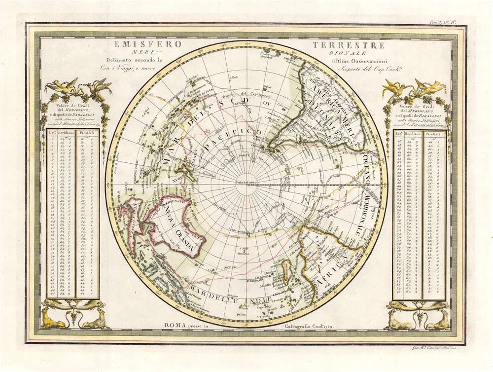
Emisfero Terrestre Meridionale Delineato secondo le ultime Osserrvazioni Con i Viaggi, e nuove Scoperte del Cap. Cook.
1789 (dated) 13 x 18 in (33.02 x 45.72 cm) 1 : 75000000
1789 (dated) 13 x 18 in (33.02 x 45.72 cm) 1 : 75000000
Description
A superb example for Giovanni Maria Cassini's elegantly engraved map of the Southern Hemisphere. The map shows the tracks of all four of Captain Cook's famous voyages, including the return track taken by his survivors after his 1779 death in Hawaii. The map shows Cook's mapping of Australia and New Zealand (from his first voyage of 1768 - 1771) and his circumnavigation of the Antarctic Circle, in search of the still-undiscovered southern continent (Terre Australis). The map is flanked with tables (decorated with birds, beasts and vines) giving the distances between meridians at different latitudes.
Publication History and Census
This map was printed in 1789 for inclusion in Cassini's Nuovo atlante geografico universale delineato sulle ultime osservazioni. The book was published in 1792, with updates following to 1801. The separate map is rare: we see only six examples catalogued in OCLC, and the complete book is shown only at the Bayerische Staatsbibliothek, BCU Dorigny, and Deutsches Museyn Munchen.CartographerS
Giovanni Maria Cassini (1745 - 1824) was a Rome based Italian mathematician, globe maker, geographer, engraver, and cartographer active in the later part of the 18th and early 19th century. He was a disciple of Giovanni Battista Piranesi. He invented new form of projection used for an atlas of the kingdom of Naples issued by Giovanni Antonio Rizzi Zannoni. Cassini is best known as a globe maker and is considered the last of the great 18th century globe makers. His maps are distinctive for their fine engraving, dark strong impressions, and elaborate distinctive cartouche work. Unlike many map and atlas publishers of the period, Cassini did all of his own engraving work - this impregnating each map with his unmistakable style. Though he produced a significant corpus of well-regarded work, little is known of Cassini's personal life. G. M. Cassini is often mistakenly associated with the well-known French cartographic family of the same name, however, they are not related. More by this mapmaker...
Captain James Cook (7 November 1728 - 14 February 1779) is a seminal figure in the history of cartography for which we can offer only a cursory treatment here. Cook began sailing as a teenager in the British Merchant Navy before joining the Royal Navy in 1755. He was posted in America for a time where he worked Samuel Holland, William Bligh, and others in the mapping of the St. Lawrence River and Newfoundland. In 1766 Cook was commissioned to explore the Pacific and given a Captaincy with command of the Endeavour. What followed were three historic voyages of discovery, the highlights of which include the first European contact with eastern Australia, the discovery of the Hawaiian Islands (among many other Polynesian groups), the first circumnavigation of New Zealand, some of the first sightings of Antarctica, the first accurate mapping of the Pacific Northwest, and ultimately his own untimely death at the hands of angry Hawaiians in 1779. The influence of Cook work on the mapping and exploration of the Pacific cannot be understated. Learn More...
Source
Cassini, G. M., Nuovo Atlante Geografico Universale (Venice) 1789.
Giovanni Maria Cassini's Nuovo Atlante Geografico Universale was published between 1792 and 1801. The atlas consisted of three volumes, published in 1792, 1797, and 1801, respectively. The first volume was dedicated to 24 globe gores, 12 terrestrial gores and 12 celestial gores, printed in three gore sections, which could be demounted from the atlas and, following Cassini's provided instructions, constructed into a globe. The terrestrial globe is based upon Captain James Cook's voyages, the last of which aboard the HMS Resolution was completed in 1779. The celestial globe makes use of the research of John Flamsteed (1646-1719) and Nicolas Louis de Lacaille (1713-1762). The second and third volumes contains geographical maps. The second volume in particular, features important maps of America and Asia. Cassini published this atlas in Rome.
Condition
Fine condition with generous margins and a bold strike. Fine hand color.
References
Rumsey 14000.028. OCLC 222940631.