1774 Benard/ Hawkesworth Chart of the Strait of Le Maire
StraitLeMaire-benard-1774$950.00

Title
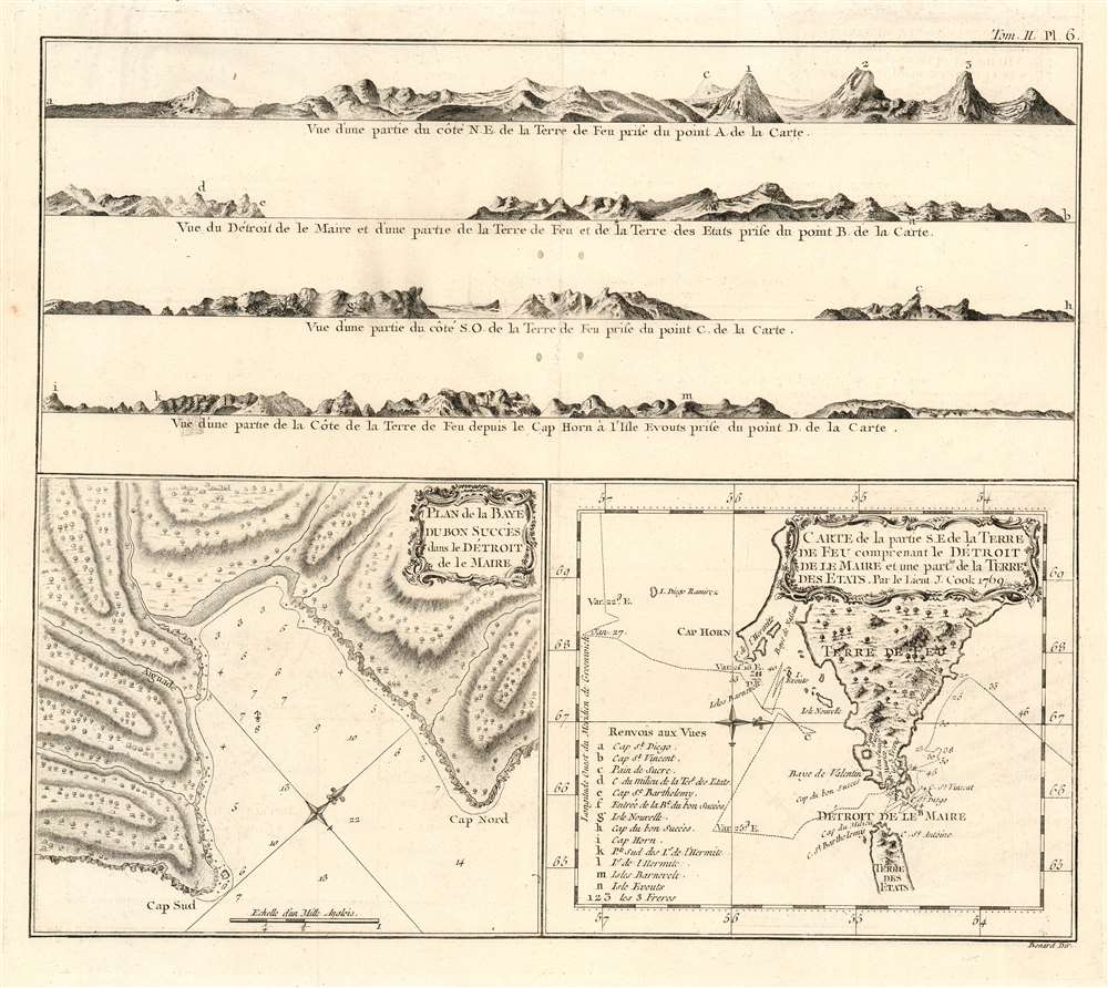
Plan de la Baye Du Bon Succés dans le Détroit de le Maire/ Carte de la partie S. E. de la Terre de Feu comprenant le Détroit de Le Maire et une Partie de la Terre Des Etats. Par le Lieut. J. Cook 1769.
1774 (undated) 12 x 14 in (30.48 x 35.56 cm) 1 : 4500000
1774 (undated) 12 x 14 in (30.48 x 35.56 cm) 1 : 4500000
Description
This 1774 Hawkesworth map of the Strait of Le Maire details the passage through the strait made by Lieutenant Cook (1728-1779) during his 1769 circumnavigation aboard HMS Endeavor. This, Cook's first Pacific voyage, was undertaken in order to observe the 1769 transit of Venus from Tahiti. The relevant portion of the voyage diverged sharply from its precursors, in that Cook took Endeavor through the Strait of Le Maire, rather than that of Magellan, thereafter sailing south to find evidence of the legendary Terra Australis Incognita.
Two Charts, plus Coastal Profiles
The map actually consists of two charts, and an accompanying set of coastal profiles. The lower left corner of the engraving is a north-west oriented chart of the Bahia Buen Suceso, on the western shore of the Strait of Le Maire. The rocky coastline, sparsely-forested hills, and the beach at the western extreme of the bay are quite recognizably depicted here. Cook’s anchorage is shown, along with a thorough set of depth soundings. The west-oriented chart in the lower right hand corner shows Cook’s passage through the Strait, including depth soundings and magnetic variations. Topographical features and vegetation are shown pictorially. A key provides numerical and alphabetical references to locations shown in the coastal views, so that the reader can see a navigator’s-eye-view of the features named on the chart. Such coastal profiles, on a working nautical chart, provided the navigator incontrovertible proof that he was (or was not) correct in his navigational calculations: such a view, paired with a chart, provided a picture of what he ought to be seeing were he at the location indicated on the chart. In this case, the chart was not intended for navigation, but the views provided armchair-traveler audience the only glimpse of these remote and forbidding coastlines they were ever likely to get.Publication History and Census
This chart was engraved for inclusion in John Hawkesworth's Relation des voyages entrepris par ordre de Sa Majeste britannique actuellement regnante, in its French edition of 1774. The separate engraving appears to be neglected by institutional collections, appearing catalogued only at Princeton according to OCLC. The full text is well represented in institutional collections.CartographerS
Robert Bénard (1734 - c. 1785) was a French engraver. Born in Paris, Bénard is best known for supplying a significant number of plates (at least 1,800) for the Encyclopédie published by Diderot and Alembert. He also is remembered for his work with the Académie des Sciences, most notably the Descriptions des Arts et Métiers More by this mapmaker...
John Hawkesworth (c. 1715 - November 16, 1773) was an English born writer and editor born London. Hawkesworth, who is said to have been self educated, succeeded Samuel Johnson as the parliamentary debate compiler for "Gentleman's Magazine". He was a deeply religious and moral map who brilliant defense of morality earned him an LL. D degree from the Archbishop of Canterbury. Hawkesworth went on to publish a series of scholarly books and essays including a 12 volume edition of Jonathan Swift's work. In 1772 Hawkesworth was commissioned by the Admiralty to compile and edit James Cook's journals. The resultant work An Account of the Voyages undertaken ... for making discoveries in the Southern Hemisphere was one of the first ethnographic account of the South Seas and was widely published in England and abroad. Though highly influential, Hawkesworth's work received heavy criticism from scholars who claim that he liberally altered much of the text in the name of morality. Learn More...
Captain James Cook (7 November 1728 - 14 February 1779) is a seminal figure in the history of cartography for which we can offer only a cursory treatment here. Cook began sailing as a teenager in the British Merchant Navy before joining the Royal Navy in 1755. He was posted in America for a time where he worked Samuel Holland, William Bligh, and others in the mapping of the St. Lawrence River and Newfoundland. In 1766 Cook was commissioned to explore the Pacific and given a Captaincy with command of the Endeavour. What followed were three historic voyages of discovery, the highlights of which include the first European contact with eastern Australia, the discovery of the Hawaiian Islands (among many other Polynesian groups), the first circumnavigation of New Zealand, some of the first sightings of Antarctica, the first accurate mapping of the Pacific Northwest, and ultimately his own untimely death at the hands of angry Hawaiians in 1779. The influence of Cook work on the mapping and exploration of the Pacific cannot be understated. Learn More...
Source
Hawkesworth, John Relation des voyages entrepris par ordre de Sa Majeste britannique actuellement regnante. (Paris : Chez Saillant et Nyon) 1774
Condition
Very good condition. Four filled wormholes not impacting printed image. Deckled edges.
References
OCLC 437814595.