Digital Image: 1556 Ramusio Map of Sumatra
Sumatra-ramusio-1556-2_d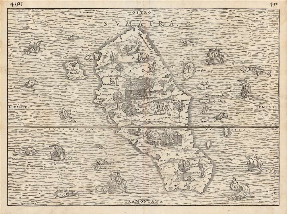

Title
Sumatra/ Taprobana.
1556 (undated) 11 x 14.75 in (27.94 x 37.465 cm)
1556 (undated) 11 x 14.75 in (27.94 x 37.465 cm)
Description
FOR THE ORIGINAL ANTIQUE MAP, WITH HISTORICAL ANALYSIS, CLICK HERE.
Digital Map Information
Geographicus maintains an archive of high-resolution rare map scans. We scan our maps at 300 DPI or higher, with newer images being 600 DPI, (either TIFF or JPEG, depending on when the scan was done) which is most cases in suitable for enlargement and printing.
Delivery
Once you purchase our digital scan service, you will receive a download link via email - usually within seconds. Digital orders are delivered as ZIP files, an industry standard file compression protocol that any computer should be able to unpack. Some of our files are very large, and can take some time to download. Most files are saved into your computer's 'Downloads' folder. All delivery is electronic. No physical product is shipped.
Credit and Scope of Use
You can use your digial image any way you want! Our digital images are unrestricted by copyright and can be used, modified, and published freely. The textual description that accompanies the original antique map is not included in the sale of digital images and remains protected by copyright. That said, we put significant care and effort into scanning and editing these maps, and we’d appreciate a credit when possible. Should you wish to credit us, please use the following credit line:
Courtesy of Geographicus Rare Antique Maps (https://www.geographicus.com).
How Large Can I Print?
In general, at 300 DPI, you should at least be able to double the size of the actual image, more so with our 600 DPI images. So, if the original was 10 x 12 inches, you can print at 20 x 24 inches, without quality loss. If your display requirements can accommodate some loss in image quality, you can make it even larger. That being said, no quality of scan will allow you to blow up at 10 x 12 inch map to wall size without significant quality loss. For more information, it is best consult a printer or reprographics specialist.
Refunds
If the high resolution image you ordered is unavailable, we will fully refund your purchase. Otherwise, digital images scans are a service, not a tangible product, and cannot be returned or refunded once the download link is used.
Cartographer
Giovanni Battista Ramusio (July 20, 1485 - July 10, 1557) was an Italian civil servant, humanist, scholar, historian, and geographer active in the middle part of the 16th century. Ramusio spent most of his life in the service of the Republic of Venice, first as part of that state's embassy to France, and later as a reporter on voyages and discoveries. He was born to an illustrious family in Treviso and moved to Vencie as a young man, where his father was a magistrate. He studied at the University of Padua but may not have received a full degree. He entered the civil service shortly after leaving the university and was immediately assigned to diplomatic service for his facility with languages, particularly French. His most significant contribution to cartography is his publication of Navigationi et Viaggi a collection of travel narratives he collected in his service to the state. The narratives include those of Marco Polo, Niccolò Da Conti, Magellan, Alvar Nuñez Cabeza de Vaca, Giosafat Barbaro, and Tomé Pires, among others. Some of the voyages appearing in the Navigationi et Viaggi are otherwise unknown, marking it as an exceptionally important volume. Ramusio died in Venice in 1557. More by this mapmaker...
Source
Ramusio, G. B., Navigationi et Viaggi, (Venice) 1556.
References
OCLC 316555278. Suarez, T. Early Mapping of Southeast Asia p.157, and fig.77.