
This item below is out of stock, but another example (left) is available. To view the available item, click "Details."
Details
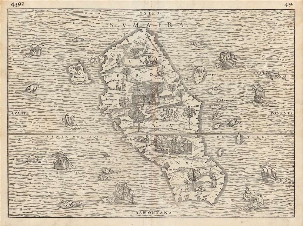
1556 / 1606 Ramusio Map of Sumatra
$1,250.00
1556 Ramusio Map of Sumatra
Sumatra-ramusio-1556-2$650.00

Title
Sumatra/ Taprobana.
1556 (undated) 11 x 14.75 in (27.94 x 37.465 cm)
1556 (undated) 11 x 14.75 in (27.94 x 37.465 cm)
Description
This is the seminal 1556 Giovanni Battista Ramusio map of Sumatra, 'the first separate map of any Southeast Asian island to be based on actual observation' (Suarez) and one of the first European maps to focus narrowly on so remote a part of the world. It appeared in Ramusio's i>Navigationi et Viaggi, the first collection of explorers' first-hand accounts of their travels. The source for this map came from the reports of Jean and Raoul Parmentier, who in 1529 ran the Portuguese blockade and attempted to compete with that power on behalf of the French by setting up a trading post at the Sumatran port of Ticon. It didn't work out - the Parmentier brothers died of fever, and only one ship of the expedition returned to France. The French saw no advantage in following up on this failure.
The woodcut represents the first glimpse in print of any specific Southeast Asian island, and this alone would make it desirable. It is moreover a very attractively executed woodcut: the sea around the island teems with fish, sea monsters, and ships - some of these bearing the Portuguese arms, and some flying the fleur de lis, alluding to the map's political context. There is also an element of Ramusio encouraging his French audience, suggesting that whatever the Portuguese have found in the world, the French ought to be able to take.
The map of the island is the first to entirely abandon Ptolemy's depiction of Taprobana, and along with Münster is among the first to associate that placename definitively with Sumatra rather than Ptolemy's conflation of the place with Sri Lanka. Moreover, it is the first map to approach an accurate outline of Sumatra, realistically showing river inlets and bays on the coastline. The island's inland features are presented pictorially, showing trees, dwellings, animals, and people - men leading horses and camels, armed soldiers, men on horseback, and others harvesting coconuts. The variety and specificity of the depicted denizens suggest the presence of, and the author's familiarity with, organized social structures on Sumatra: an indication that here was not an uncivilized place, (like Ramusio's demon-haunted map of Canada), but somewhere one could go to do business.
The Mapmakers
Ramusio, in the introduction to his Navigationi et Viaggi, wrote that he asked Giacomo Gastaldi to provide maps for his work. It is not known whether the great Venetian cartographer did so himself: this map certainly does not resemble Sumatra as it appears on Gastaldi's 1548 map of Southeast Asia, although the island as depicted in his 1561 map of the region bears some similarity, so Gastaldi may have become familiar with this geography via the same reports informing Ramusio.Publication History and Census
This map was first cut by Matteo Pagano for inclusion in the 1556 third volume of Ramusio's Navigationi et Viaggi. The woodblocks for this, and indeed all the maps of the 1556 edition, burned in a 1557 warehouse fire. It appears in only one known state. The blocks were all re-engraved, probably again by Pagano, for the 1565 edition of the Navigationi et Viaggi. The second block is geographically identical to the first; the two blocks are most easily distinguishable by differences in the trees appearing behind the various buildings. That second block was employed one more time in 1606, this edition easily identifiable by the small worm-shaped blank areas (woodworm appears to have similarly infested all blocks of the 1606 edition.) The 1556 edition of the third volume of Navigationi et Viaggi. is rare. Seven examples of the 1565 are listed in OCLC, while perhaps twenty of the 1606 edition appear in institutional collections. Only one example of this separate map is cataloged in OCLC, appearing in the National Library of Scotland.Cartographer
Giovanni Battista Ramusio (July 20, 1485 - July 10, 1557) was an Italian civil servant, humanist, scholar, historian, and geographer active in the middle part of the 16th century. Ramusio spent most of his life in the service of the Republic of Venice, first as part of that state's embassy to France, and later as a reporter on voyages and discoveries. He was born to an illustrious family in Treviso and moved to Vencie as a young man, where his father was a magistrate. He studied at the University of Padua but may not have received a full degree. He entered the civil service shortly after leaving the university and was immediately assigned to diplomatic service for his facility with languages, particularly French. His most significant contribution to cartography is his publication of Navigationi et Viaggi a collection of travel narratives he collected in his service to the state. The narratives include those of Marco Polo, Niccolò Da Conti, Magellan, Alvar Nuñez Cabeza de Vaca, Giosafat Barbaro, and Tomé Pires, among others. Some of the voyages appearing in the Navigationi et Viaggi are otherwise unknown, marking it as an exceptionally important volume. Ramusio died in Venice in 1557. More by this mapmaker...
Source
Ramusio, G. B., Navigationi et Viaggi, (Venice) 1556.
Condition
Fine. Manuscript corrections to pagination (430 to 433, and 431 to 434 respectively) as with virtually every example of this map.
References
OCLC 316555278. Suarez, T. Early Mapping of Southeast Asia p.157, and fig.77.