This item has been sold, but you can get on the Waitlist to be notified if another example becomes available, or purchase a digital scan.
1879 Map of the Swedish and Dutch Arctic Expeditions
SwedishDutchArcticExpeditions-stanford-1879$187.50

Title
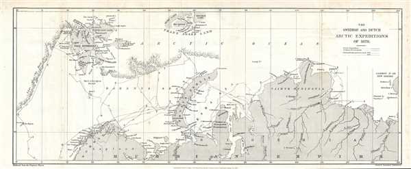
The Swedish and Dutch Arctic Expeditions of 1878.
1879 (dated) 9 x 22.5 in (22.86 x 57.15 cm) 1 : 6900000
1879 (dated) 9 x 22.5 in (22.86 x 57.15 cm) 1 : 6900000
Description
This is a rare 1879 Sir Clements Robert's map of the Arctic. This map depicts the northern coast of Russia (Russian Empire), Lapland and Norway the Arctic Ocean, and the edge of the ice sheet. Novaya Zemlya (Novaya Zemlia), the Kara Sea, and the Taymyr (Taimyr) Peninsula are also depicted. Several rivers are included in Siberia and the coastline is depicted in astonishing detail.
This map was created to accompany Sir Clements Robert https://'s paper The Arctic Expeditions of 1878 for the January 1879 edition of the Proceedings of the Royal Geographical Society and Monthly Record of Geography. In his paper, https:// discussed the Swedish and Dutch expeditions of the previous year, 1878, in some detail. The major accomplishment of the Swedish expedition was that they were the first to round the Promontorium Tabin of Pliny, the most northern point of the Old World. The Dutch expedition of 1878 was meant to be a reconnaissance mission for a proposed second voyage.
This map was created by Stanford's Geographical Establishment and published in the Proceedings of the Royal Geographical Society and Monthly Record of Geography in January 1879.
Cartographer
Edward Stanford (May 27, 1827 - November 3, 1904) was one of the most prolific map publishing firms of the late 19th century. The company began as a partnership in 1848 between the 21 year old Edward Stanford and the established map dealer Trelawney Saunders. By 1853 the partnership had dissolved and Edward Stanford took full control of the business. A subsequent series of expansions and exciting new map issues finally led to the production of Stanford's masterwork, "Stanford's Library Map of London". This map is still available and remains somewhat accurate. At the time of publishing it was hailed by the Royal Geographical Society as "the most perfect map of London that has ever been issued". In 1882 Edward Stanford Sr. passed the firm on to his son, Edward Stanford Jr. who continued in his father's proud tradition. Today the Stanford firm still publishes maps and remains one of the most important and prolific cartographic publishers in the world. More by this mapmaker...
Source
C.R., 'The Arctic Expeditions of 1878', Proceedings of the Royal Geographical Society and Monthly Record of Geography Vol. 1, No. 1, January 1879, Royal Geographical Society.
Condition
Very good. Blank on verso. Light foxing.
References
OCLC 46632642.