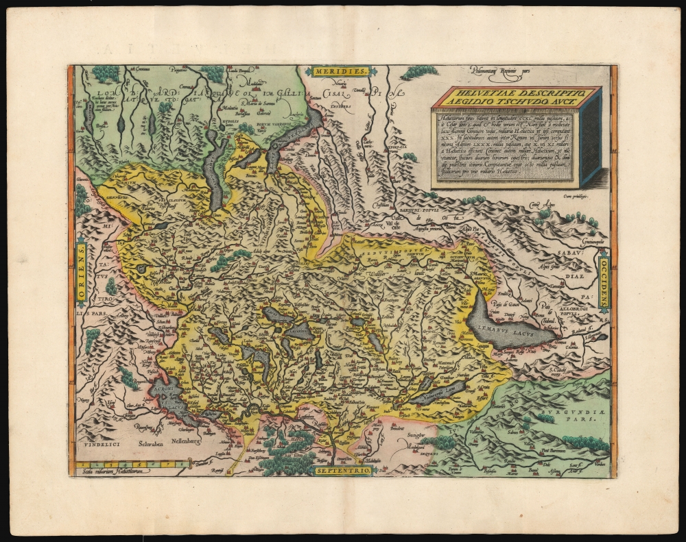
1595 Ortelius Map of Switzerland
Switzerland-ortelius-1570-2$1,000.00


Title
Helvetiae Descriptio Aegidio Tschudo Auct.
1570 (undated) 13.5 x 18 in (34.29 x 45.72 cm) 1 : 1100000
1570 (undated) 13.5 x 18 in (34.29 x 45.72 cm) 1 : 1100000
Description
This is Abraham Ortelius' 1570 map of Switzerland, the first to appear in a modern atlas, in superb original color. This richly detailed, southern-oriented map provided the best delineation of the Swiss Confederation of the sixteenth century.
In the upper left, that is to say the southeastern extreme of the map, is the Lago di Garda: a brief Latin text explains 'It is said that this lake produces gold grains of sand, brought by the River Mincius'
A Closer Look
Coverage extends from southern Germany and France, including the headwaters of the Danube River in Swabia and it reaches as far south as the Piedmont and Savoy. Switzerland's rivers, mountains, and lakes are depicted in vigorous detail. The map's title cartouche is presented as a great block, or box, with writing on three sides: the top bearing the title and author, the facing side describing Switzerland's location and extent. The text of the shadowed right face, bafflingly, describes the chimney-sweep denizens of the Valley of Vegets in the Canton of Ticino, who plied their trade throughout Europe.In the upper left, that is to say the southeastern extreme of the map, is the Lago di Garda: a brief Latin text explains 'It is said that this lake produces gold grains of sand, brought by the River Mincius'
The Source
Ortelius credits this map to the Swiss statesman, historian, and forger Aegidius Tschudi. Although Tschudi's history of the Swiss Confederation was not published until well into the 18th century, his influence on the mapping of Switzerland was already established. Sebastian Münster's maps of the country, printed first in 1538 and again in 1540 for his Geographia and Cosmographia, were both derived from Tschudi's manuscripts. Ortelius' work, however, was drawn from a more courant 1565 Tschudi manuscript. This second state of the map has several place names added that did not appear on the earlier version: notably Neruy, Ripaille and Bellerive on the south bank of Lake Geneva.Publication History and Census
This map was engraved in 1570 and included in the first Latin editions of Ortelius' Theatrum. The plate remained in use throughout the work's long print run. It conforms to the first state of the map as described by van den Broecke. The second state, with which the present example corresponds, first appeared in 1584. This example agrees typographically with the 1595 Latin text edition, of which van den Broecke estimates there were 500 printed.CartographerS
Abraham Ortelius (April 14, 1527 - June 28, 1598) also known as Ortels, was a cartographer, geographer, and cosmographer of Brabant, active in Antwerp. He was the creator of the first modern atlas, Theatrum Orbis Terrarum and is a seminal figure in the history of cartography. Along with Gerard Mercator and Gemma Frisius, he was a founder of the Netherlandish school of cartography. His connections with Spain - culminating in his 1575 appointment as Royal Cartographer to King Phillip II of Spain - gave him unmatched access to Spanish geographical knowledge during a crucial period of the Age of Discovery. Ortelius was born in 1527 in Antwerp. In 1547 he entered the Antwerp Guild of Saint Luke as an illuminator of maps. He began trading in books, prints, and maps, traveling regularly to the Frankfurt book and print fair, where in 1554 he met Mercator. He accompanied Mercator on journeys throughout France in 1560 and it was at this time, under Mercator's influence, that he appears to have chosen his career as a scientific geographer. His first published geographic work appeared in 1564, an eight-sheet cordiform world map. A handful of other maps preceded the 1570 publication of the first edition of the Theatrum Orbis Terrarum, which would prove to be his life work. Appearing with but 53 maps in its first edition, Ortelius' work expanded with new maps added regularly. By 1592, it had 134 maps. Many of Ortelius' maps remained the standard for nearly a century. He traveled extensively, but his genius was as a compiler, locating the best informed maps on which to base his own. His contacts throughout Europe and extending even (via the Portuguese) to the Far East were formidable. Moreover, many of his maps were based on his own scholarship, particularly his historical works. His theories of geography were particularly ahead of his time with respect to the notion of continental drift, the possibility of which he mused on as early as 1596, and which would be proven correct centuries later.
In a sense his greatest achievement was his successful navigation of the religious and political violence endemic to his city throughout his adult life: The Dutch Revolt, or Eighty Years' War (1568 - 1648), fully embroiled Antwerp. Although outwardly and officially recognized as Catholic (Arias Montanus vouched for Ortelius' Catholic orthodoxy prior to his appointment as Royal Geographer), Ortelius was able to separate himself from the religious furor which characterized the war in the low countries. Ortelius showed a glimpse of himself in a letter to a friend, regarding humanist Justus Lipsius: 'I do not know whether he is an adherent of the Pope or a Calvinist, but if he has ears to hear, he will neither be one nor the other, for sins are committed on both sides'. Ortelius' own explorations of Biblical history in his maps, and the Christogram contained in his own motto, suggest him to be a religious man, but his abjuration of political religious authorities mark him as an individualist. His tombstone at St Michael's Præmonstratensian Abbey in Antwerp bears the inscription, Quietis cultor sine lite, uxore, prole. ('served quietly, without accusation, wife, and offspring.') More by this mapmaker...
Aegidius (Giles, Glig) Tschudi (February 5, 1505 – February 28, 1572) was a Swiss statesman and historian, best known as the author of the Chronicon Helveticum, a history of the early Swiss Confederation. Tschudi served in public offices throughout his life. In 1558, he became a chief magistrate and was sent as ambassador to the court of Emperor Ferdinand, who in turn ennobled him in 1559. His most important works were not published until well after his death. His greatest work, the Chronicon Helveticum, was not published until the 1730s. Despite this, Tschudi's scholarship did not go unnoticed and circulated in unpublished manuscript throughout European learned circles: Ortelius's 1570 map of Switzerland, for example, was based on his work. As a historian, Tschudi earned criticism: his writings relied on forged documents to fraudulently exaggerate his family's significance. Learn More...
Source
Ortelius, A., Theatrum Orbis Terrarum, (Antwerp: Plantin) 1595.
Abraham Ortelius' magnum opus, Theatrum Orbis Terrarum, was the world's first regularly produced atlas, which 'set the standards for later atlases . . . It was the first undertaking of its kind to reduce the best available maps to an uniform format.' (Koeman) A modestly-sized work of fifty-three maps in its first edition of May 1570, it was an immediate success: there were three further editions that year, and the work remained in print for a total of 32 editions, the last of which was 1641, well after its author's 1598 death. Ortelius added to his atlas constantly, and by 1595 the Theatrum contained 147 maps. Ortelius is renowned generally as an editor, and indeed much of the Theatrum is compiled from a variety of sources: in such cases, Ortelius was scrupulous in naming his sources. But Ortelius was also a mapmaker in his own right: many of his maps are a distillation of various sources into his own work, and there were many maps - particularly in his atlas of Biblical and ancient history Parergon - which were entirely Ortelius' work. In his role as an editor, Ortelius followed in the footsteps of Munster, whose Cosmographia was, until Ortelius, the best window on the world for the curious European reader. In terms of the artistry of his maps, Ortelius oversaw the first great flourishing of copperplate engraving in the service of cartography to occur in Northern Europe. Ortelius' work provided the model for the atlases of Mercator, Hondius, Blaeu and all their progeny in the 17th century - many of whom were to produce faithful editions of Ortelius' maps in their own productions.
Condition
Very good. One area of scuffing at centerfold minimally impacting printed image. Else excellent with a bold, sharp strike and fine original color.
References
Rumsey 10000.071. Koeman Ort 1B. Van der Krogt, P. C. J., Koeman's Atlantes Neerlandici, (3 Vols), 4900:31. van den Broecke, M., Ortelius Atlas Maps #115 State 2. Blumer, W., 'Aegidius Tschudi’s second map of Switzerland,' Imago Mundi VIII p. 70.