Digital Image: 1949 Gillman Map of Vegetation in Tanganyika (Tanzania)
TanganyikaVegetation-gillman-1949_d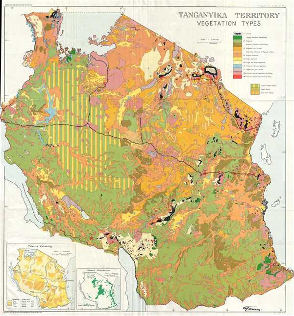

Title
Tanganyika Territory Vegetation Types.
1949 (dated) 24 x 22.5 in (60.96 x 57.15 cm) 1 : 2000000
1949 (dated) 24 x 22.5 in (60.96 x 57.15 cm) 1 : 2000000
Description
FOR THE ORIGINAL ANTIQUE MAP, WITH HISTORICAL ANALYSIS, CLICK HERE.
Digital Map Information
Geographicus maintains an archive of high-resolution rare map scans. We scan our maps at 300 DPI or higher, with newer images being 600 DPI, (either TIFF or JPEG, depending on when the scan was done) which is most cases in suitable for enlargement and printing.
Delivery
Once you purchase our digital scan service, you will receive a download link via email - usually within seconds. Digital orders are delivered as ZIP files, an industry standard file compression protocol that any computer should be able to unpack. Some of our files are very large, and can take some time to download. Most files are saved into your computer's 'Downloads' folder. All delivery is electronic. No physical product is shipped.
Credit and Scope of Use
You can use your digial image any way you want! Our digital images are unrestricted by copyright and can be used, modified, and published freely. The textual description that accompanies the original antique map is not included in the sale of digital images and remains protected by copyright. That said, we put significant care and effort into scanning and editing these maps, and we’d appreciate a credit when possible. Should you wish to credit us, please use the following credit line:
Courtesy of Geographicus Rare Antique Maps (https://www.geographicus.com).
How Large Can I Print?
In general, at 300 DPI, you should at least be able to double the size of the actual image, more so with our 600 DPI images. So, if the original was 10 x 12 inches, you can print at 20 x 24 inches, without quality loss. If your display requirements can accommodate some loss in image quality, you can make it even larger. That being said, no quality of scan will allow you to blow up at 10 x 12 inch map to wall size without significant quality loss. For more information, it is best consult a printer or reprographics specialist.
Refunds
If the high resolution image you ordered is unavailable, we will fully refund your purchase. Otherwise, digital images scans are a service, not a tangible product, and cannot be returned or refunded once the download link is used.
Cartographer
Clement Gillman (November 26, 1882 - 1946) was a geographer, cartographer, engineer, hydrographer, and intellectual of Anglo-Swiss and German ancestry. During his entire working life, Gillman shuttled between East Africa and Europe, working for the railroads as an engineer, and gathering scientific knowledge, which he condensed into several papers which were published in scholarly journals.
Gillman was born in Madrid to his father, Fritz Gillman, who was managing his father’s silver mines in Spain, and his mother, Margarete von Petzholdt, a German national who grew up in Estonia. In 1900, at the age of seventeen, Gillman entered a five year engineering course in Zurich at the Technical High School. Upon completing his studies, Gillman was offered an appointment as Assistant Engineer with Phillip Holzman and Company of Frankfurt-am-Main. The firm also happened to be the contractors for the construction of the first section of the Central Railway in German East Africa. Following a short stint working at the company headquarters in Frankfurt, Gillman set off for East Africa and arrived in Dar es Salaam on October 21, 1905.
Gillman instantly took to life in East Africa, stating that he felt an ‘increasing love for life away from ‘civilization.’’ He became the engineer in charge of several successive sections the central railway as it pushed across German East Africa. After twenty-three months in Africa, Gillman received his first leave and returned to Europe, where he stayed until June 1908. While in Europe he married Eva Kerber on February 22, 1908. They returned to Africa together and arrived in July 1908. Gillman continued his work as engineer in charge of the construction of the railroad until his next European leave in August 1912. Once back in Africa, Gillman was put in charge of the preliminary survey for the proposed Kagera railway to Rwanda. This was only a short deployment, after which Gillman returned to Europe, until definitive plans were made for a survey in May 1914, when he returned to Africa with his wife and two sons. But, with the outbreak of the First World War, the Kagera railway was abandoned.
The Gillman family spent WWI in East Africa, and Clement spent almost two years as a civilian prisoner of war. By September 1916, the Belgians had occupied Tabora, where the Gillman family was living. Gillman left his family in Tabora and went to Dar es Salaam, where he was commissions as a 2nd Lieutenant in the British East Africa Protectorate Force and attached to the Railway Corps. Due to his Anglo-German descent, Gillman was not immune to exceedingly difficult treatment during the war year, writing in 1917 of, ‘renewed attacks by my enemies, and much suffering due to suspicion and intrigue.’ In March 1919, Gillman received two months military leave in England and began searching for what to do now that the war was over. After a venture in Brazil with his uncle never materialized, Gillman decided to ‘sell his soul’ to the Colonial Office.
Gillman was back in Africa by December 1919, and was made District Engineer in charge of the Tanga District. By May 1920, he had a permanent post in the Colonial Office and in 1921 was named District Engineer Tanganyika Railways. From July 1925 to February 1926, Gillman conducted reconnaissance for a proposed rail route to Lake Nyassa, which he bluntly stated, was an impossible proposition involving a criminal waste of money. In 1928 Gillman was appointed to the post of Chief Engineer, Tanganyika Railways.
His scholarly work truly began in 1930, Gillman’s eighth journey to East Africa. From this time on, he would produce a steady stream of papers, letter, notes, and reviews on a great variety of subjects. His time was spent almost constantly traveling, conducting surveys and inspection work. His passion for hydrography led to two memoranda on floods in East Africa, while his love for mountaineering led him to compile a bibliography of Kilimanjaro, which he scaled on several occasions. In 1933 he published a report on the hydrology of Lake Tanganyika. His last tour of duty began in February 1937, which was filled with routine inspections, essentially a farewell tour. He retired at the end of the year from his post as Chief Engineer, until his final retirement in 1940.
Retirement meant anything but a lessening of activity for Gillman, even during the war years. For the last six years of his life, even with a generally failing standard of health, he made numerous tours of East Africa. The King George V Memorial Museum opened in December 1940, with Mrs. Gillman as its first curator. He published over thirty works during these years, including eleven which count as major papers. He produced a paper on ‘clouds and cloudscapes’ in 1940, which was the embryonic form of a cloud atlas which Gillman intended to produce after the war. He also published a history of the building of the Tanganyika Railway. The crowning achievement of his career, however, was published posthumously in 1949. This was a study and map of vegetation-types of Tanganyika. This was his magnum opus on which he spent over 1,000 hours during the last two years of his life. He completed a draft of the map on a scale of 1 : 500000 in January 1946, which the final version being sent to Geographical Review on September 20. He died a few weeks late, on October 5, while flying from Dar es Salaam to Moshi, engaged in making notes of the journey.
More by this mapmaker...
Source
Gillman, C., 'A Vegetation-Types Map of Tanganyika Territory', Geographical Review Vol. 39, No. 1 (Jan. 1949) p. 7-37.