This item has been sold, but you can get on the Waitlist to be notified if another example becomes available, or purchase a digital scan.
1943 F. E Manning World War II Propaganda World Map: Target Tokyo
TargetTokyo-manning-1943$175.00

Title
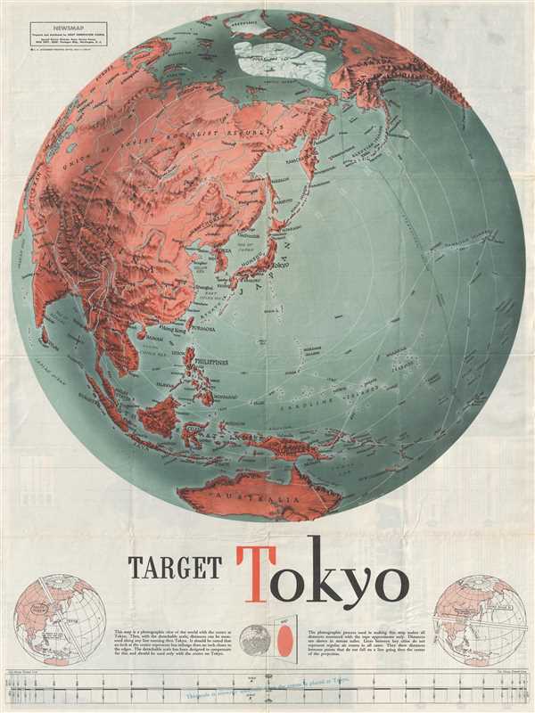
Target Tokyo; Newsmap. Monday, October 25, 1943.
1943 (dated) 23.5 x 17.5 in (59.69 x 44.45 cm) 1 : 4400000
1943 (dated) 23.5 x 17.5 in (59.69 x 44.45 cm) 1 : 4400000
Description
One of the most iconic American World War II propaganda map, these are F. E Manning's 1943 propaganda broadside 'Target Tokyo’. The focus of the broadsides are dramatic shaded panoptic views centered on Tokyo from which a series of concentric circles radiate creating a distinctive target-like effect. The ever widening circles extend to include much of the world.
The second broadside, Target Tokyo, is formally titled Newsmap. Monday, October 18, 1943, Vol. II No. 26, was actually issued first, but did not reflect significant bombing efforts in the Asia-Pacific theater. It was not until the introduction of the B-29 Superfortress long range bomber was introduced in 1944 that significant strikes commenced. These continued from November 17, 1944 to August 15 1945, the day that Japan capitulated.
Below the maps there is an ingenious cut away distance scale and the following instructions,
These are two of many 'Newsmaps' published weekly by the Army Orientation Course of the Special Service Division Army Service Forces, a propaganda arm of the United States War Department. The Newsmaps typically employed bold typesetting and dramatic imagery to relay the most recent war news from a distinctly 'positive' perspective. Few Newsmaps were as dramatic or impactful as Manning's 'Target Tokyo’. This reduced version of the newsmap was prepared and distributed by Army Orientation Course, Special Service Division Army Service Forces, War Dept. Washington D. C. and printed at the U. S. Government Printing Office.
The second broadside, Target Tokyo, is formally titled Newsmap. Monday, October 18, 1943, Vol. II No. 26, was actually issued first, but did not reflect significant bombing efforts in the Asia-Pacific theater. It was not until the introduction of the B-29 Superfortress long range bomber was introduced in 1944 that significant strikes commenced. These continued from November 17, 1944 to August 15 1945, the day that Japan capitulated.
Below the maps there is an ingenious cut away distance scale and the following instructions,
This map is a photographic view of the world with the center at Tokyo. Thus with the detachable scale distances can be measured along any line running thru Tokyo. It should be noted that an inch at the center represents less mileage than an inch closer to the edges. The detachable scale has been designed to compensate for this and should be used only with the center on Tokyo. The photographic process used in making this map makes all distances measured with the tape approximate only. Distances are shown in statute miles. Lines between key cities do not represent regular air routes in all cases. They show distances between points that do not fall on a line going thru the center of the projection.The verso of the map features a segmented breakdown of the most recent war news on various fronts. Most of it is quite good for the Allies. Following a series of Allied victories in Italy, Russia, at Stalingrad, in East Asia, and Indonesia, the War had, by this date, turned firmly against the Axis powers. As such, there was little need for 'sugar coating' and the general message was, in as much as war can be, truthfully positive.
These are two of many 'Newsmaps' published weekly by the Army Orientation Course of the Special Service Division Army Service Forces, a propaganda arm of the United States War Department. The Newsmaps typically employed bold typesetting and dramatic imagery to relay the most recent war news from a distinctly 'positive' perspective. Few Newsmaps were as dramatic or impactful as Manning's 'Target Tokyo’. This reduced version of the newsmap was prepared and distributed by Army Orientation Course, Special Service Division Army Service Forces, War Dept. Washington D. C. and printed at the U. S. Government Printing Office.
Cartographer
F. E. Manning (fl. c. 1940 - 1945) was an American journalistic cartography employed with the Chicago Sun. During World War II he produced numerous propagandistic maps for the Army Orientation Course of the Special Service Division Army Service Forces, a division of the United State War Department. Our research has, unfortunately, been able to unearth significant details regarding his personal life or his career at the Chicago Sun. More by this mapmaker...
Condition
Very good. Minor wear on original fold lines. Some foxing.
References
OCLC: 62771943.