Digital Image: 1884 Royce Map of Former Cherokee Land in the Middle United States
TerritorialLimitsCherokee-royce-1884_d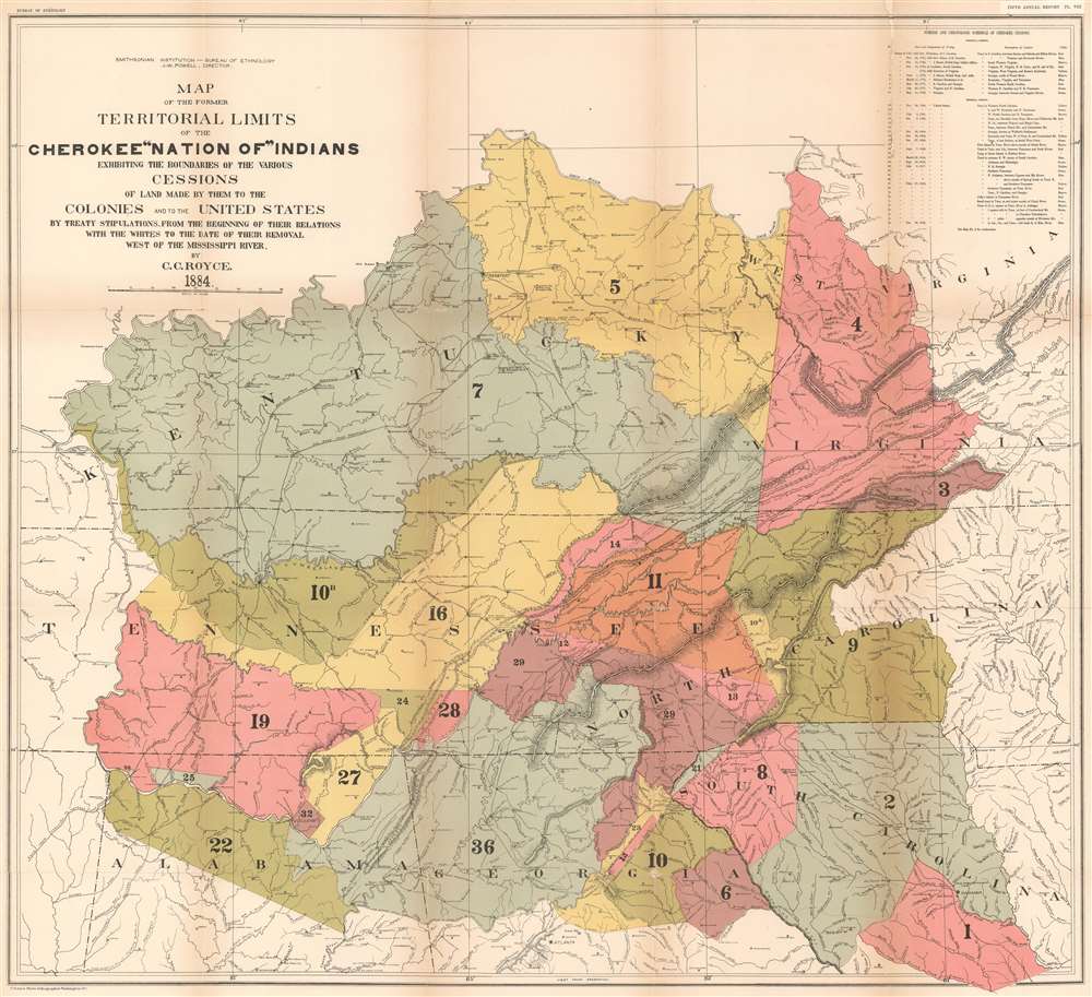

Description
FOR THE ORIGINAL ANTIQUE MAP, WITH HISTORICAL ANALYSIS, CLICK HERE.
Digital Map Information
Geographicus maintains an archive of high-resolution rare map scans. We scan our maps at 300 DPI or higher, with newer images being 600 DPI, (either TIFF or JPEG, depending on when the scan was done) which is most cases in suitable for enlargement and printing.
Delivery
Once you purchase our digital scan service, you will receive a download link via email - usually within seconds. Digital orders are delivered as ZIP files, an industry standard file compression protocol that any computer should be able to unpack. Some of our files are very large, and can take some time to download. Most files are saved into your computer's 'Downloads' folder. All delivery is electronic. No physical product is shipped.
Credit and Scope of Use
You can use your digial image any way you want! Our digital images are unrestricted by copyright and can be used, modified, and published freely. The textual description that accompanies the original antique map is not included in the sale of digital images and remains protected by copyright. That said, we put significant care and effort into scanning and editing these maps, and we’d appreciate a credit when possible. Should you wish to credit us, please use the following credit line:
Courtesy of Geographicus Rare Antique Maps (https://www.geographicus.com).
How Large Can I Print?
In general, at 300 DPI, you should at least be able to double the size of the actual image, more so with our 600 DPI images. So, if the original was 10 x 12 inches, you can print at 20 x 24 inches, without quality loss. If your display requirements can accommodate some loss in image quality, you can make it even larger. That being said, no quality of scan will allow you to blow up at 10 x 12 inch map to wall size without significant quality loss. For more information, it is best consult a printer or reprographics specialist.
Refunds
If the high resolution image you ordered is unavailable, we will fully refund your purchase. Otherwise, digital images scans are a service, not a tangible product, and cannot be returned or refunded once the download link is used.
Cartographer S
Charles C. Royce (December 22, 1845 - February 11, 1923) was an American author, ethnographer, cartographer, and businessman. Born in Defiance, Ohio, Royce enlisted in the U.S. Navy three month before his nineteenth birthday. He served as Acting Master's Mate on the monitor U.S.S. Neosho during the last months of the U.S. Civil War. After his honorable discharge from the Navy, Royce elected to seek employment in Washington, D.C., where he found a job as a clerk in the Office of Indian Affairs. John Wesley Powell, the first head of the Bureau of Ethnology, became aware of Royce's work concerning Indian land cessions, and helped Royce pursue his work. Powell provided funds for research trips and borrowed books for Royce from the Library of Congress. In February 1883, Royce gained an appointment as an ethnologist in the Bureau of Ethnology, but chose to leave Washington, D.C. and return to Ohio the following year, where he found work as an accountant at the Miami County Bank. Royce submitted the manuscript of his work The Cherokee Nation before returning to Ohio, and was disappointed when its publication was delayed for a year. The Cherokee Nation is regarded as a valuable contribution to literature about the American Indian, as is his monumental Indian Land Cessions in the United States, which was also published by the Bureau of Ethnology. Royce became the manager of Ranco Chico, a California fruit ranch, in 1888. He retired in 1912, and moved back to Washington, D.C., where he suffered from ill health until his death. He married Isabella Harter in 1871 and the couple never had any children. More by this mapmaker...
The Bureau of Ethnology (1879 - 1965) was a bureau of the United States government tasked with transferring the records, archives, and other materials relating to Native Americans from the Interior Department to the Smithsonian Institution. The bureau's visionary founding director, John Wesley Powell, saw the bureau's mission as a much broader endeavor. He believed from the start that the bureau's mission was 'to organize anthropologic research in America'. Under Powell's leadership, the bureau sponsored ethnographic, archaeological, and linguistic field research; organized research-intensive multi-year projects; promoted the fledgling discipline of anthropology; and initiated publication series, including its Annual Reports and Bulletins. The bureau also collected anthropological samples for the Smithsonian United States Museum and prepared exhibits for expositions. The bureau's name changed in 1897 to the Bureau of American Ethnology, indicating the scope of its work, and in 1965 the Bureau of American Ethnology merged with the Smithsonian's Department of Anthropology to for the Smithsonian Office of Anthropology within the United States National Museum (today known as the Department of Anthropology, National Museum of Natural History). Learn More...
Source
Bureau of Ethnology, Fifth Annual Report (Washington) 1884.
References
OCLC 57212182.