1747 Astley / Mead Map of Tibet
Tibet-astley-1747-2$1,100.00

Title
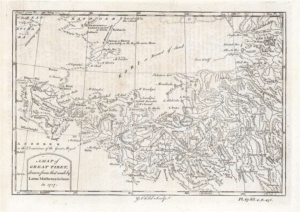
A Map of Great Tibet, drawn from that made by Lama Mathematicians in 1717.
1747 (undated) 6 x 9 in (15.24 x 22.86 cm) 1 : 10134000
1747 (undated) 6 x 9 in (15.24 x 22.86 cm) 1 : 10134000
Description
This is the earliest English map of Tibet, engraved for Braddock Mead's A New General Collection of Voyages and Travels, published under his pseudonym 'John Green' by Thomas Astley in 1747. It is one of the few maps of the region to rely (ultimately) on local sources - although the mapmaker's claim that the map was 'drawn from that made by Lama Mathematicians' does not include the chain of Jesuit missionaries and French cartographers linking the 'Lama Mathematicians' to the 'English engraver'. The map covers an area from northern India (Delhi is identified) to encompass the Gobi Desert and as far as Kashgar. The map includes Lake Kokonor in the Qinghai Province of China and embraces what is now the Xinjiang Uyghur Autonomous Region. The Himalaya Mountains of Tibet appear pictorially, but the map is rich in place names and rivers, including several rivers disappearing into the endoheiric basins of the Gobi.
The Lamas and the Jesuits
The map's origin in 'Lama Mathematicians in 1717' refers to a map prepared by French Jesuits, a labor begun in 1708. The map was completed with the blessing of Qing Emperor Kangxi who considered it a means to control newly conquered areas. The scholars initially produced a map of the Great Wall, following it to its westernmost extents on the frontier of Tibet, near Lake Kukunor / Kokonor. This map having pleased the Emperor, they pressed on with the Chinese interior, and the frontiers. The Jesuits were not permitted to explore Tibet, Korea, and Turkestan themselves, but instead were constrained to rely on measurements provided by Chinese officials (who, as per Manchu colonial practice, were Tibetan.) Tibet was surveyed twice in this manner, and the results compiled (with the rest of the China survey) in the so-called Kangxi Atlas, of which one copy is cataloged by OCLC in the British Library. As important as this groundbreaking work was, it would not be generally disseminated until the appearance of D'Anville's maps in the 1735 Du Halde Description géographique, historique, chronologique, politique, et physique de l'Empire de la Chine et de la Tartarie chinoise, which presented the labors of the French Jesuits for the first time. It was Du Halde who credited Jesuit sources with acquiring their maps from Tibetan Lamas at the order of the Chinese Emperor, and from whom the reference to the 'Lama Mathematicians' was derived. D'Anville's 1735 Carte Generale du Thibet ou Bout-tan et des Pays de Kashgar et Hami, based on the relevant portions of the Kangxi Atlas, would be the first accurate cartographic depiction of Tibet available in the western world, and would remain the authoritative model for the mapping of Tibet for half a century. 'Green' and Astley had ample access to this map via their engraver, George Child, who between 1738 and 1741 engraved maps and views for the English edition of Du Halde. The D'Anville map was certainly at his fingertips when he produced the present map.Publication History and Census
The map was engraved by George Child for inclusion in the 1747 fourth volume of Braddock Mead's A New General Collection of Voyages and Travels, published by Thomas (not Rick) Astley. The separate map is listed only once, at the National Library of Scotland. Astley's Collection is well represented in institutional collections.CartographerS
Thomas Astley (died 1759) was a bookseller and publisher in London active predominantly between 1734 and 1747. His early history is a cipher and we know nothing of his education or training. He was a member of the Worshipful Company of Stationers, so there must have been an apprenticeship. Between 1727 and 1742 he printed and sold books from a Saint Paul's Churchyard address; starting in 1745 he sold his work from Paternoster Row. He is most remembered for his four-volume, 1745-48 Voyages and Travels which continued in the tradition of travel books by Hakluyt, Purchas, John Atkins, Jean Barbot, Willem Bosman, Theodor de Bry, Francis Moore, Jean-Baptiste Labat, Godefroi Loyer, Thomas Phillips, William Smith, and Nicolas Villaut de Bellefond - to the extent of recapitulating those earlier works. Astley's Voyages included maps engraved by George Child and Nathaniel Parr. Astley was an early publisher of the 'London Magazine,' founded in 1732 to compete with and oppose the Tory 'Gentlemen's political opposition and rivalry to the Tory 'Gentleman's Magazine.' Astley's publication in the magazine of the treason trial of the Jacobite Simon Lord Lovat led to Astley's arrest and punishment with fines (trials of peers in the House of Lords were meant to be secret). Though he regained his freedom upon his examination by the House of Lords (having pointed out that he was merely reprinting what had already been made public in the penny press) Astley was removed as publisher of the Magazine; there were no further volumes added to his Voyages and Travels. He died in 1759 survived by his wife and daughter (both named Susanna) who inherited his remaining stock and his pension from the Company of Stationers. More by this mapmaker...
Braddock Mead (c. 1688 - 1757), also known as John Green, was an Irish cartographer and map engraver active in London during the middle part of the 18th century. Mead is one of the most interesting and colorful figures in cartography whose louche personal life sharply contrasted with the high standard of his maps. Mead was born in Ireland around 1688 and seems to have come from a good family and received a respectable education. His brother Thomas Mead held the position of Lord Mayor of Dublin in 1757. Braddock Mead left Dublin for London around 1717 where he plunged into vice, subsidizing his cartographic work with hack work and gambling. In 1728 Mead fell in with a plot to defraud a 12 year old Irish heiress, Bridget Reading, of her fortune by kidnapping and marrying her himself. Mead suffered jail time for the crime but was more fortunate than his partner, a fellow Irishman named Kimberly, who was hanged. As a cartographer Mead cannot have exhibited a more antithetical character. He held himself and others to the highest standards of accuracy and scholarship, and issued a call for greater transparency in the field of mapmaking. Mead worked with Ephraim Chambers on the Universal Dictionary, as well as with Cave and Astley in the publication of various travelogues and explorer's journals, notably Astley’s New General Collection of voyages and travels. Eventually he came to work for the publishing house of Thomas Jefferys, who saw through Mead's personal failings to appreciate his cartographic brilliance. Mead has been called the genius behind Jefferys and he seems to have had a hand in the production of many of Jefferys' most important maps. William Cumming notes that Mead
had a number of marked characteristics as a cartographer ... One was his ability to collect, to analyze the value of, and to use a wide variety of sources; these he acknowledged scrupulously on the maps he designed and even more fully in accompanying remarks. Another outstanding characteristic was his intelligent compilation and careful evaluation of reports on latitudes and longitudes used in the construction of his maps, which he also entered in tables on the face of the maps ... Mead's contributions to cartography stand out ... At a time when the quality and the ethics of map production were at a low ebb in England, he vigorously urged and practiced the highest standards; in the making of maps and navigational charts he was in advance of his time. For this he deserves due credit.Learn More...
Jean Baptiste Bourguignon d'Anville (1697 - 1782) was perhaps the most important and prolific cartographer of the 18th century. D'Anville's passion for cartography manifested during his school years when he amused himself by composing maps for Latin texts. There is a preserved manuscript dating to 1712, Graecia Vetus, which may be his earliest surviving map - he was only 15 when he drew it. He would retain an interest in the cartography of antiquity throughout his long career and published numerous atlases to focusing on the ancient world. At twenty-two D'Anville, sponsored by the Duke of Orleans, was appointed Geographer to the King of France. As both a cartographer and a geographer, he instituted a reform in the general practice of cartography. Unlike most period cartographers, D'Anville did not rely exclusively on earlier maps to inform his work, rather he based his maps on intense study and research. His maps were thus the most accurate and comprehensive of his period - truly the first modern maps. Thomas Basset and Philip Porter write: "It was because of D'Anville's resolve to depict only those features which could be proven to be true that his maps are often said to represent a scientific reformation in cartography." (The Journal of African History, Vol. 32, No. 3 (1991), pp. 367-413). In 1754, when D'Anville turned 57 and had reached the height of his career, he was elected to the Academie des Inscriptions. Later, at 76, following the death of Philippe Buache, D'Anville was appointed to both of the coveted positions Buache held: Premier Geographe du Roi, and Adjoint-Geographer of the Academie des Sciences. During his long career D'Anville published some 211 maps as well as 78 treatises on geography. D'Anville's vast reference library, consisting of over 9000 volumes, was acquired by the French government in 1779 and became the basis of the Depot Geographique - though D'Anville retained physical possession his death in 1782. Remarkably almost all of D'Anville's maps were produced by his own hand. His published maps, most of which were engraved by Guillaume de la Haye, are known to be near exact reproductions of D'Anville' manuscripts. The borders as well as the decorative cartouche work present on many of his maps were produced by his brother Hubert-Francois Bourguignon Gravelot. The work of D'Anville thus marked a transitional point in the history of cartography and opened the way to the maps of English cartographers Cary, Thomson and Pinkerton in the early 19th century. Learn More...
George Child (born 1706, fl. 1737-1753) was an English engraver, based in London. The son of a gardener, he was given a charitable apprenticeship as a goldsmith in 1720 (not an uncommon early training among engravers.) He produced maps for the English edition of du Halde’s ‘description the empire of China and Chinese-Tartary’ and Thomas Astley’s ‘New General Collection of voyages and travels,’ among other works. He was also known for his landscapes and views. Learn More...
Source
Green, J. (Mead, Braddock), A New General Collection of Voyages and Travels, (London: Astley) 1747.
Condition
Very good condition. Some text show-through, else excellent.
References
OCLC 316559455. Crone, G. R. and Skelton, R. A., 'English Collections of Voyages and Travels, 1625-1848', Richard Hakluyt and His Successors: A Volume Issued to Commemorate the Centenary of the Hakluyt Society.