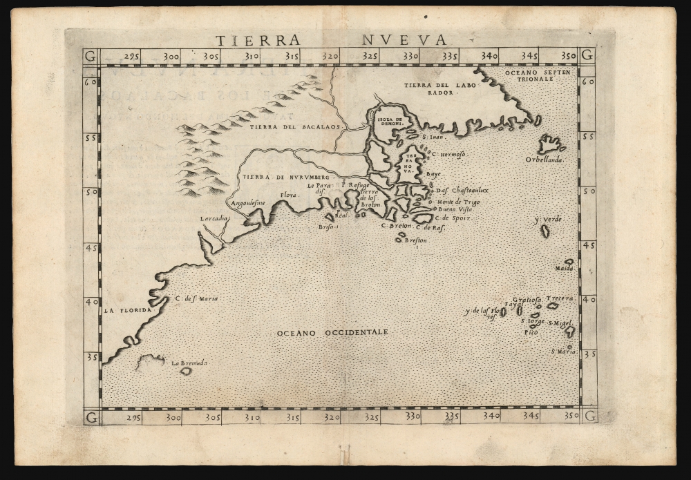
1574 Ruscelli Map of New England and the Maritimes (Norumbega)
TierraNveva-ruscelli-1574-2$2,000.00

Title
Tierra Nueva.
1574 (undated) 7.5 x 10.5 in (19.05 x 26.67 cm) 1 : 21000000
1574 (undated) 7.5 x 10.5 in (19.05 x 26.67 cm) 1 : 21000000
Description
This is Girolamo Ruscelli's 1574 map Tierra Nueva, one of the earliest maps to focus on the North American East Coast and the Canadian Maritime Provinces.
A few years later, David Ingram - having survived the 1562 shipwreck of an English slave ship in the Gulf of Mexico - claimed to have trekked overland from there to Nova Scotia, where he was rescued by a passing French ship. Inspired by Mexican legends of El Dorado, Cibola, and other lost cities, Ingram returned to Europe with further boasts of a fabulous city rich in pearls and built upon pillars of crystal, silver, and gold. Naturally, expeditions were sent to search for the city - including that of Samuel de Champlain.
A Closer Look
The map covers the eastern coastline of North America from somewhere in upper Florida northwards past Cabo de Santa Maria to Larcadia (Kitty Hawk), Angoulesme (New York Harbor), Narragansett Bay, Newfoundland, Nova Scotia, and Labrador. Ruscelli's work follows on the 1548 map of the same region by fellow Venetian Giacomo Gastaldi but presents it in larger scale, with greater legibility.Reconciling the Toponomy
Cartographically, this map offers a fascinating look at early cartographers' attempts to reconcile the discoveries of Giovanni Verrazzano with those of Jacques Cartier. 'Larcadia', named by Verrazzano because of its forested beauty, is now assumed to have been somewhere near Kitty Hawk. 'Angoulesme' was the place name Verrazzano gave to New York Harbor (although Andre Thevet, writing in 1550, also took credit for the term). 'Flora' is most likely the south coast of Long Island. 'Brisa' is Block Island, and 'Pt. Refuge' is Narragansett Bay. The Chesapeake Bay, Delaware Bay, Cape Cod, and Boston Harbor are notably absent, as Verrazzano was forced too far out to sea for fear of reefs to see their entrances.Verrazzano and Cartier
Gastaldi's efforts to the discoveries of Giovanni Verrazzano and Jacques Cartier run afoul of the fact that Cartier's voyage did not reach as far south as Verrazzano's did north, with the result that a swath of the New England coast was not included in the present work. Cartier never sailed south of Prince Edward Island, and Verrazzano barely skirted the southern tip of Nova Scotia; thus, 'C. Breton' (Cape Breton Island) appears where one might expect to find Cape Cod. The mass of islands and rivers, with names like 'Isola de Demoni' (Island of Demons) and 'Terra Nova,' is an early effort to comprehend the coast of Maine around the Penobscot River, Nova Scotia, Newfoundland, the Gulf of St. Lawrence, and Labrador. Labrador, here thus labeled as 'Tierra del Labrorador', is vaguely recognizable as it juts out into the sea. 'Orbellanda,' a term derived from Arthurian legend, is similarly recognizable as Newfoundland. Both are clearly based on Cartier's explorations.Ramusio's River System
The river system extending inland both from the speculative St. Lawrence Bay (around Isola de Demoni and Terra Nova) and from Angoulesme (New York Harbor), thus joining the Hudson with the St. Lawrence, and at the same time embracing the mysterious land of 'Tierra de Nurumberg,' is incorporated from Giovanni Battista Ramusio's 1556 La Nuova Francia, which may have been composed in concert with Gastaldi. It should be noted that the region encompassed by these rivers on this map is depicted on Ruscelli's world map as a massive island - a feature not depicted either on Gastaldi's precursor to the present work or on his surviving world maps. His portrayal of the rivers on this map is likely done to reconcile this narrower map to the geography on his world map.Nurembega
The mysterious 'Tierra de Nurumbeg' appeared on many early maps of New England, starting with Verrazzano's 1529 manuscript map of America. He used the term Oranbega, which in Algonquin means something on the order of 'lull in the river.' The first detailed reference to the place appeared in the 1542 journals of the French navigator Jean Allefonsce - a well-respected navigator who, in 1542, explored the coast in conjunction with Jean-François de la Roque de Roberval's attempt to colonize the region. Allefonsce apparently sailed some distance up the Penobscot River, there encountering a settlement near modern-day Bangor, Maine:The river is more than 40 leagues wide at its entrance and retains its width some thirty or forty leagues. It is full of Islands, which stretch some ten or twelve leagues into the sea. ... Fifteen leagues within this river there is a town called Norombega, with clever inhabitants, who trade in furs of all sorts; the town folk are dressed in furs, wearing sable. ... The people use many words which sound like Latin. They worship the sun. They are tall and handsome in form. The land of Norombega lies high and is well situated.Though Roberval's colony lasted only two years, Andre Thevet, writing in 1550, records encountering a French trading fort at that location.
A few years later, David Ingram - having survived the 1562 shipwreck of an English slave ship in the Gulf of Mexico - claimed to have trekked overland from there to Nova Scotia, where he was rescued by a passing French ship. Inspired by Mexican legends of El Dorado, Cibola, and other lost cities, Ingram returned to Europe with further boasts of a fabulous city rich in pearls and built upon pillars of crystal, silver, and gold. Naturally, expeditions were sent to search for the city - including that of Samuel de Champlain.
Publication History and Census
This map was engraved by Giulio Sanuto for inclusion in Girolamo Ruscelli's 1561 edition of La Geografia di Claudio Tolomeo. It was reissued in various editions of the work, without changes, until 1564. The first state can be recognized by a pressmark that runs off the top of the page. The plate was retooled in 1574; the current example corresponds to this edition. This state of the map is characterized by crosshatching added to the graduation marks, as well as the visible top edge of the copperplate. A third state would appear in 1598 with many revisions, including the addition of a sea monster, a ship, and the placenames 'Virginia' and 'Nova Francia.' This map comes to the market from time to time and is well represented in institutional collections as a staple of early cartography of North America.CartographerS
Girolamo Ruscelli (1500 - 1566) was an Italian polymath, humanist, editor, and cartographer active in Venice during the early 16th century. Born in Viterbo, Ruscelli lived in Aquileia, Padua, Rome and Naples before relocating to Venice, where he spent much of his life. Cartographically, Ruscelli is best known for his important revision of Ptolemy's Geographia, which was published posthumously in 1574. Ruscelli, basing his work on Gastaldi's 1548 expansion of Ptolemy, added some 37 new "Ptolemaic" maps to his Italian translation of the Geographia. Ruscelli is also listed as the editor to such important works as Boccaccio's Decameron, Petrarch's verse, Ariosto's Orlando Furioso, and various other works. In addition to his well-known cartographic work many scholars associate Ruscelli with Alexius Pedemontanus, author of the popular De' Secreti del R. D. Alessio Piemontese. This well-known work, or "Book of Secrets" was a compilation of scientific and quasi-scientific medical recipes, household advice, and technical commentary on a range of topics that included metallurgy, alchemy, dyeing, perfume making. Ruscelli, as Alexius, founded a "Academy of Secrets," a group of noblemen and humanists dedicated to unearthing "forbidden" scientific knowledge. This was the first known experimental scientific society and was later imitated by a number of other groups throughout Europe, including the Accademia dei Secreti of Naples. More by this mapmaker...
Livio Sanuto (1520 – 1576) was a Venetian cartographer and scientific instrument maker produced, with his engraver brother, Giulio (fl. 1540-1588) – an array of some of the most important geographical works produced in Venice during the second half of the sixteenth century. These included a 27-inch globe and the 1588 12-sheet atlas, Geografia della Africa. Among Livio and Giulio's works were some, if not all of the maps prepared for Ruscelli's 1561 Ptolemy. Learn More...
Giulio Sanuto (fl. 1540 – 1580) was a Venetian engraver. He was born the illegitimate son of Cavaliere Francesco di Angelo Sanuto; With his brother, the cartographer and scientific instrument maker Livio Sanuto (1520 – 1576) he produced an array of some of the most important geographical works produced in Venice during the second half of the sixteenth century. These included a 27-inch globe and the 1588 12-sheet atlas, Geografia della Africa. Giulio's career is singluar among Venice's engraves in that it appears to have been equally based on artistic, figurative work as well as his cartographic works. Giulio is more broadly known for a small but sought-after selection of decorative engravings; no more than twelve of these can be attributed confidently to him, including the monumental Apollo and Marsyas, measuring over 1.30 meters wide. Whilst Sanuto's engravings were generally based upon the designs of other artists, his work was both ambitious and grand, and he often signed these works. Learn More...
Source
Ruscelli, G., La Geografia di Claudio Tolomeo Alessandrino…, (Venice: Giordano Ziletti) 1574.
Beginning in 1561, Girolamo Ruscelli published this important, expanded edition of Giacomo Gastaldi's 1548 Ptolemy. Its maps, engraved in Venice by Giulio Sanuto, were in the main based directly upon those in Gastaldi's 1548 work. The maps were larger format than Gastaldi's, however, and Sanuto's engraving was far clearer and more legible than those appearing in the 1548 work. There are some important additions that distinguish Ruscell's Ptolemy from Gastaldi's. Ruscelli's work contained a map of the habitable world according to Ptolemy, which the Gastaldi lacked; also, the double-hemisphere map appearing in the Ruscelli was new and did not appear in the Gastaldi. Ruscelli's modern map of England was based on the work of George Lily, rather than the Waldseemüller-derived map appearing in the Gastaldi; the Ruscelli is the earliest generally acquirable map of England based on knowledge from someone who lived there. In a fateful innovation, Ruscelli's work included Septentrionalium partium nova tabula,the first copy of Nicolo Zeno's 1558 fraud Carta da Navegar, which introduced a novel mapping of the north parts of the world, including the phantom islands of Frisland, Icaria, Drogeo and Estotiland. Had Ruscelli not copied the Zeno - which had a narrow, brief publication - this preposterous geography would have probably not taken hold. Its inclusion in Ruscelli's beautiful, authoritative and popular work would lead to the adoption of the Zeno map by Mercator, Ortelius, Plancius and their successors, baffling scholars for centuries. Ruscelli's Ptolemy had a long publication history, cementing the influence of the work. It appeared both in Italian and Latin editions, all printed in Venice, throughout the latter 16th century:
- 1561 La Geographia di Claudio Tolomeo Alessandrino, Italian. Venice, Vincenzo Valgrisi.
- 1562 Geographia Cl. Ptolemaei Alexandrini, Latin. Venice, Vincenzo Valgrisi.
- 1564 La Geographia di Claudio Tolomeo Alessandrino, Italian. Venice, Giordano Ziletti.
- 1564 Geographia Cl. Ptolemaei Alexandrini, Latin. Venice, Giordano Ziletti.
- 1574 La Geographia di Claudio Tolomeo Alessandrino, Italian. Venice, Giordano Ziletti.
- 1598 Geographia di Claudio Tolomeo Alessandrino, Italian. Venice, heirs of Melchoir Sessa.
- 1599 Geographia di Claudio Tolomeo Alessandrino, Italian. Venice, heirs of Melchoir Sessa.
Condition
Very good. Marginal mend at bottom centerfold not entering image, else excellent with a bold strike.
References
Burden, P., The Mapping of North America, #30. Kershaw, K. A., Early Printed Maps of Canada, pp. 22-23. OCLC 50920440.