This item has been sold, but you can get on the Waitlist to be notified if another example becomes available, or purchase a digital scan.
1840 Burr / Colton Topographical Map of New York City (Manhattan)
TopographicalMapNewYork-colton-1840$14,500.00

Title
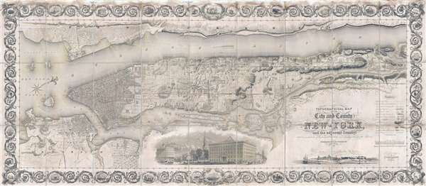
Topographical Map of the City and County of New-York, and the adjacent Country: With Views in the border of the principal Buildings and interesting Scenery of the Island.
1840 (dated) 30.5 x 70 in (77.47 x 177.8 cm) 1 : 16000
1840 (dated) 30.5 x 70 in (77.47 x 177.8 cm) 1 : 16000
Description
Known as 'The Colton Map,' this is an unrecorded state of an 1840 map of New York City (Manhattan) by David H. Burr and John Hutchins Colton considered to be the finest and most decorative map of the city to appear in the 19th century. According to map historian I. N. Phelps Stokes, Colton's map is
It is of note that, while the Commissioner's Plan attempted to do away with Broadway, being offended by its irregular course, Colton and Burr, recognizing the ancient American Indian road as a popular and practical artery, included it on their grand map. The fact that Broadway, here identified as Bloomingdale Road, is represented not as a ghosted path, as on the 1811 Commissioner's Plan or the 1829 Burr Map, but rather as a major street, leads to the first cartographic indication of several major squares that arose due to Broadway's awkward intersection with the grid, including Union Square, Madison Square, and Times Square.
It is generally believed that this map was prepared for Colton by David H. Burr due to a promotional advertisement that appeared in the July 16, 1833 edition of the New York Commercial Advertiser, which reads
The map offers much else of interest on nearly every level. It illustrates of the early estates of the wealthy above 30th street. Several early boundary lines, such as between New York and Harlem Commons and the 'Original Divisions between New York and Harlem' are shown as drawn from Randal's surveys. The map identifies public schools, including Public School 9, located on 79th and Broadway. The sites of early roadside hotels, such as the Kingsbridge Hotel, in Marble Hill, where travelers could rest on their way into Manhattan from what is now the Bronx. The modern-day site of Columbia University was a Lunatic Asylum. Just west of the Receiving Reservoir, near 85th Street, some of the buildings and a graveyard associated with the African American community known as Seneca Village are illustrated. In Brooklyn, some of the emerging street structure is ghosted in, giving evidence to the growth of that, then separate, city. Similarly, Williamsburg, also a separate city, is noted on the opposite side of the Wallabout.
The map is surrounded by a host of illustrations both on the map and integrated into double border. At bottom center, there is a dramatic engraving illustrating 'Broadway from the Park', the 'park' here being City Hall Park. St. Paul's Chapel and the American Museum are evident in the background. To this right of this image is a controversial c. 1650 view of New York City under the Dutch West India Company. That view is here dated 1659, but this date is incorrect as it is based upon an earlier anonymous watercolor, now located at the Albertina Museum, from 1648. The view appears on the 1655 Vischer Map, Novi Belgii Novae que Angliae nec non partis Virginiae Tabula, after which it is commonly known as the 'Vischer View.'
The double border features an inner border that represents a surveyor's chain, and an outer, far more elaborate border, consisting of acanthus leaves framing engravings of regional fauna, and, from top left, counterclockwise, 'Windmill, Jersey City,' 'Custom-House, Wall St.,' 'City Hall, Wall St.,' sailing ships, the city seal, steam ships, the Palisades, Columbia College, St. Thomas Church, the Protestant Episcopal Seminary, a Female Orphan Asylum (Bloomingdale), New York Harbor from the Battery, Cortlandt Street Landing, St. Luke's Church, the Brooklyn Navy Yard, New York from Governor's Island, Castle Garden, the Deaf and Dumb Asylum, Barclay Street Landing, and The Hall of Justice (the Tombs).
The first printing of this map appeared in 1836, making it one of J. H. Colton's earliest works. There are at least three states. The first appears to have been issued in 1836 and lacks Madison Square Park, which was commissioned in 1837. A second issue, also bearing the date 1836, features the park, and likely represents the cartographer's forward thinking. Map historian Daniel Haskell, who identifies it as 'The Colton Map,' lists 3 dated issues 1836, 1841, and 1845. The present printing bears the date of 1840, marking it as a previously unknown state. It differs form the 2nd 1836 edition with regard to the track of the Croton Aqueduct from the Receiving Reservoir on 80th street to the Distributing Reservoir on 40th Street. The earlier state, which predates the construction of the pipeline, assumes it will run along 6th Avenue. The later edition routes the pipeline along Middle Road, or 5th Avenue. The aspect of the Distributing Reservoir also changes, as by 1840, when this map was issued, more advanced plans were in place.
It was engraved by Samuel Stiles and Company of New York. Apparently, some of the plates survived at least until 1868, when the norther plate was reused by William Rogers to create Map of the Upper Part of the island of Manhattan Above Eighty-Sixth Street arranged to Illustrate the Battle of Harlem Heights for Joseph Shannon's Manual of the City and Corporation of New York. That map stands out from all of other lithograph prints in the manual as it is a steel plate engraving. All issues of the present map, with the exception of the partial proof at the Metropolitan Museum of Art, are lithograph. This suggests that the original map was engraved on steel, probably by Burr. Burr probabaly abondoned the project when he took a position as the head topographer for the United States Postal Service, in 1833. Colton then struck Burr's name from the plates and turned to Samuel Stiles to complete the engraving and transfer the plates to lithographic stones for publication in 1836.
Today this map is extremely scarce and exhibits no market history in the past 30 years. Intuitional examples are known in the New York Public Library, the Boston Public Library, The New York Historical Society, and the Library of Congress. The Metropolitan Museum of Art owns a partial working proof. One other example is part of the David Rumsey Map Collection. There are numerous citations on the OCLC but all reference the Rumsey digital resource. This is a once in a lifetime collecting opportunity.
one of the most beautiful nineteenth century plans of Manhattan, and full of information … the best example of really artistic mapmaking as applied to Manhattan IslandThe map covers all of Manhattan Island as well as part of adjacent Brooklyn, Newark, Weehawken, Jersey City, and Hoboken. It starkly contrasts the development in southern Manhattan south of 30th Street with the topographically wild uplands extending northwards and dotted with gentlemanly estates, forests, hills, rivulets, and marshland. The city's future is iterated by the street grid, which is superimposed upon the topography according to the 1811 Commissioner's Plan as far north as 155th Street.
It is of note that, while the Commissioner's Plan attempted to do away with Broadway, being offended by its irregular course, Colton and Burr, recognizing the ancient American Indian road as a popular and practical artery, included it on their grand map. The fact that Broadway, here identified as Bloomingdale Road, is represented not as a ghosted path, as on the 1811 Commissioner's Plan or the 1829 Burr Map, but rather as a major street, leads to the first cartographic indication of several major squares that arose due to Broadway's awkward intersection with the grid, including Union Square, Madison Square, and Times Square.
It is generally believed that this map was prepared for Colton by David H. Burr due to a promotional advertisement that appeared in the July 16, 1833 edition of the New York Commercial Advertiser, which reads
J. H. Colton and Company, No. 9 Wall Street, publish a new map of the city drawn by David H. Burr form the latest surveys of the city deposited in the street commissioner's office from information obtained from several of the city's surveyors.It does resemble Burr's 1829 map of New York City from the Atlas of New York in terms of coverage, orientation, and style. Nonetheless, the present map is far larger and grander, both being roughly twice the size of Burr's atlas map, and far more detailed on every level. There is evidence that Burr began work engraving this map as early as 1832 or 1833, as a partial production proof of the central part of Manhattan, attributed to Burr, survives in the collections of the Metropolitan Museum of Art (accession 24.66.1492). That example curiously lacks the Receiving Reservoir (between 80th and 86th Streets.), which was planned in 1836, following the disastrous Great New York Fire of 1835. The Receiving Reservoir did not begin to function as such until 1842, but all examples of this map, aside from the fragment noted above, show the reservoir as well as the underground route of the Croton Pipeline, then under construction.
The map offers much else of interest on nearly every level. It illustrates of the early estates of the wealthy above 30th street. Several early boundary lines, such as between New York and Harlem Commons and the 'Original Divisions between New York and Harlem' are shown as drawn from Randal's surveys. The map identifies public schools, including Public School 9, located on 79th and Broadway. The sites of early roadside hotels, such as the Kingsbridge Hotel, in Marble Hill, where travelers could rest on their way into Manhattan from what is now the Bronx. The modern-day site of Columbia University was a Lunatic Asylum. Just west of the Receiving Reservoir, near 85th Street, some of the buildings and a graveyard associated with the African American community known as Seneca Village are illustrated. In Brooklyn, some of the emerging street structure is ghosted in, giving evidence to the growth of that, then separate, city. Similarly, Williamsburg, also a separate city, is noted on the opposite side of the Wallabout.
The map is surrounded by a host of illustrations both on the map and integrated into double border. At bottom center, there is a dramatic engraving illustrating 'Broadway from the Park', the 'park' here being City Hall Park. St. Paul's Chapel and the American Museum are evident in the background. To this right of this image is a controversial c. 1650 view of New York City under the Dutch West India Company. That view is here dated 1659, but this date is incorrect as it is based upon an earlier anonymous watercolor, now located at the Albertina Museum, from 1648. The view appears on the 1655 Vischer Map, Novi Belgii Novae que Angliae nec non partis Virginiae Tabula, after which it is commonly known as the 'Vischer View.'
The double border features an inner border that represents a surveyor's chain, and an outer, far more elaborate border, consisting of acanthus leaves framing engravings of regional fauna, and, from top left, counterclockwise, 'Windmill, Jersey City,' 'Custom-House, Wall St.,' 'City Hall, Wall St.,' sailing ships, the city seal, steam ships, the Palisades, Columbia College, St. Thomas Church, the Protestant Episcopal Seminary, a Female Orphan Asylum (Bloomingdale), New York Harbor from the Battery, Cortlandt Street Landing, St. Luke's Church, the Brooklyn Navy Yard, New York from Governor's Island, Castle Garden, the Deaf and Dumb Asylum, Barclay Street Landing, and The Hall of Justice (the Tombs).
The first printing of this map appeared in 1836, making it one of J. H. Colton's earliest works. There are at least three states. The first appears to have been issued in 1836 and lacks Madison Square Park, which was commissioned in 1837. A second issue, also bearing the date 1836, features the park, and likely represents the cartographer's forward thinking. Map historian Daniel Haskell, who identifies it as 'The Colton Map,' lists 3 dated issues 1836, 1841, and 1845. The present printing bears the date of 1840, marking it as a previously unknown state. It differs form the 2nd 1836 edition with regard to the track of the Croton Aqueduct from the Receiving Reservoir on 80th street to the Distributing Reservoir on 40th Street. The earlier state, which predates the construction of the pipeline, assumes it will run along 6th Avenue. The later edition routes the pipeline along Middle Road, or 5th Avenue. The aspect of the Distributing Reservoir also changes, as by 1840, when this map was issued, more advanced plans were in place.
It was engraved by Samuel Stiles and Company of New York. Apparently, some of the plates survived at least until 1868, when the norther plate was reused by William Rogers to create Map of the Upper Part of the island of Manhattan Above Eighty-Sixth Street arranged to Illustrate the Battle of Harlem Heights for Joseph Shannon's Manual of the City and Corporation of New York. That map stands out from all of other lithograph prints in the manual as it is a steel plate engraving. All issues of the present map, with the exception of the partial proof at the Metropolitan Museum of Art, are lithograph. This suggests that the original map was engraved on steel, probably by Burr. Burr probabaly abondoned the project when he took a position as the head topographer for the United States Postal Service, in 1833. Colton then struck Burr's name from the plates and turned to Samuel Stiles to complete the engraving and transfer the plates to lithographic stones for publication in 1836.
Today this map is extremely scarce and exhibits no market history in the past 30 years. Intuitional examples are known in the New York Public Library, the Boston Public Library, The New York Historical Society, and the Library of Congress. The Metropolitan Museum of Art owns a partial working proof. One other example is part of the David Rumsey Map Collection. There are numerous citations on the OCLC but all reference the Rumsey digital resource. This is a once in a lifetime collecting opportunity.
CartographerS
David Hugh Burr (August 18, 1803 - December 25, 1875) of one of the first and most important truly American cartographers and map publishers. Burr was born in Bridgeport Connecticut in August of 1803. In 1822 Burr moved to Kingsboro, New York to study law. A year and a half later he was admitted to the New York Bar association. Burr must have questioned his choice of careers because shortly after being admitted to the Bar, he joined the New York State Militia. Though largely untrained in the art of surveying, Burr was assigned to work under Surveyor General of New York, Simeon De Witt, to survey several New York Roadways. Seeing a window of opportunity, Burr was able to negotiate with the governor of New York at the time, De Witt Clinton, to obtain copies of other New York survey work in order to compile a map and Atlas of the state of New York. Recognizing the need for quality survey work of its territory, the government of New York heartily endorsed and financed Burr's efforts. The resulting 1829 Atlas of the State of New York was the second atlas of an individual U.S. state and one of the most important state atlases ever produced. Burr went on to issue other maps both of New York and of the United States in general. In cooperation with publishing firm of Illman & Pillbrow, he produced an important New Universal Atlas and, with J.H. Colton, several very important maps of New York City. In recognition of this work, Burr was appointed both "Topographer to the Post office" and "Geographer to the House of Representatives of the United States". Later, in 1855, Burr was assigned to the newly created position of Surveyor General to the State of Utah. Burr retired from the position and from cartographic work in general in 1857 when light of some of his financial misdeeds and frauds came to light. He was accused of submitting false expense reports and underpaying employees, among other indiscretions. More by this mapmaker...
Joseph Hutchins Colton (July 5, 1800 - July 29, 1893), often publishing as J. H. Colton, was an important American map and atlas publisher active from 1833 to 1897. Colton's firm arose from humble beginnings when he moved to New York in 1831 and befriended the established engraver, Samuel Stiles. He worked under Stiles as the 'Co.' in Stiles and Co. from 1833 to 1836. Colton quickly recognized an emerging market in railroad maps and immigrant guides. Not a cartographer or engraver himself, Colton's initial business practice mostly involved purchasing the copyrights of other cartographers, most notably David H. Burr, and reissuing them with updated engraving and border work. His first maps, produced in 1833, were based on earlier Burr maps and depicted New York State and New York City. Between 1833 and 1855, Colton proceeded to publish a large corpus of guidebooks and railroad maps, which proved popular. In the early 1850s, Colton brought his two sons, George Woolworth Colton (1827 - 1901) and Charles B. Colton (1832 - 1916), into the map business. G. W. Colton, trained as a cartographer and engraver, was particularly inspired by the idea of creating a large and detailed world atlas to compete with established European firms for the U.S. market. In 1855, G.W. Colton issued volume one of the impressive two-volume Colton's Atlas of the World. Volume two followed a year later. Possibly because of the expense of purchasing a two-volume atlas set, the sales of the Atlas of the World did not meet Colton's expectations, and so, in 1856, the firm also issued the atlas as a single volume. The maps contained in this superb work were all original engravings, and most bear an 1855 copyright. All of the maps were surrounded by an attractive spiral motif border that would become a hallmark of Colton's atlas maps well into the 1880s. In 1857, the slightly smaller Colton's General Atlas replaced the Atlas of the World. Most early editions of the General Atlas published from 1857 to 1859 do not have the trademark Colton spiral border, which was removed to allow the maps to fit into a smaller format volume. Their customers must have missed the border because it was reinstated in 1860 and remained in all subsequent publications of the atlas. There were also darker times ahead; in 1858, Colton was commissioned at a sum of 25,000 USD by the government of Bolivia to produce and deliver 10,000 copies of a large format map of that country. Although Colton completed the contract in good faith, delivering the maps at his own expense, he was never paid by Bolivia, which was at the time in the midst of a series of national revolutions. Colton would spend the remainder of his days fighting with the Bolivian and Peruvian governments over this payment, and in the end, after a congressional intervention, he received as much as 100,000 USD in compensation. Nonetheless, at the time, it was a disastrous blow. J. H. Colton and Company is listed as one of New York's failed companies in the postal record of 1859. This led Colton into the arms of Alvin Jewett Johnson and Ross C. Browning. The 1859 edition of Colton's General Atlas lists Johnson and Browning as the 'Successor's to J. H. Colton' suggesting an outright buyout, but given that both companies continued to publish separately, the reality is likely more complex. Whatever the case may have been, this arrangement gave Johnson and Browning access to many of Colton's map plates and gave birth to Johnson's New Illustrated (Steel Plate) Family Atlas. The Johnson's Atlas was published parallel to Colton's atlases well into the 1880s. The Colton firm itself subsequently published several other atlases including an Atlas of America, the Illustrated Cabinet Atlas, the Octavo Atlas of the Union, and Colton's Quarto Atlas of the World. They also published a large corpus of wall maps, pocket maps, and guides. The last known publications of the Colton firm date to 1897 and include a map and a view, both issued in association with the Merchant's Association of New York. Alice M. Colton married August R. Ohman (May 3, 1859 - April 22, 1934) on January 5, 1897. In 1898, Ohman joined the Colton firm, which continued to publish as Colton, Ohman & Co. until 1901. Learn More...
Samuel Stiles (July 15, 1796 - April 3, 1861) was a New York based engraver of maps and bank notes active in the middle part of the 19th century. Stiles was born in East Windsor, Connecticut, and there served his apprenticeship as a line-engraver under self-taught master Abner Reed. In 1821, following his apprenticeship, Stiles relocated to Hartford, Connecticut, with is former master, Abner Reed, to form the firm of Reed and Stiles. Reed and Stiles worked in portrait, historical, landscape, and map engraving on wood and copper. Another former Reed apprentice, Pelton, joined the firm in 1822, changing the name of the firm to Reed, Stiles, and Pelton. Around this time, he also joined the Connecticut State Militia where he was commissioned as a corporal in the same Calvary regiment as his brother Asabel Chapin Stiles. In 1824, he relocated to Utica, New York, where worked with Vistus Balch, also a former Reed apprentice. Stiles and Balch moved to New York together in 1828 to found Balch and Stiles, banknote engravers. In 1833, Samuel Stiles partnered with Joseph Hutchins Colton, then a young man, to found Stiles and Company – Colton being the 'company.' This partnership lasted until 1836 when he and Colton published their great plan of New York City, known as the 'Colton Map.' Colton went his own way and became a major American map publisher. Stiles moved a few blocks away and partnered with George E. Sherman and Colin Smith to found Stiles, Sherman and Smith. The partnership dissolved in 1840 and Stiles took up again with J. H. Colton, who was already becoming prominent. In 1841, he joined the firm of Danforth, Ball, and Company, Bank Note Engravers. This firm eventually merged into the American Bank Note Company. In 1859 Stiles became a founding member of the National Banknote Company, which incorporated as the American Banknote Company. He was the treasurer of this successful firm until his death in 1861. On a side note, Stiles married the daughter of Abner Reed, Charlotte Sophia Reed, in 1825. Their son, Henry Reed Stiles attained fame of his own as historian and genealogist. Learn More...
Condition
Very good. Minor staining. Dissected and mounted on linen for easy folding and unfolding. Original linen exhibits wear but is stable. Accompanied by original boards, which exhibit significant wear.
References
Haskell, D., Manhattan Maps A Co-operative List, 817, 818, 819. Stokes, I. N. P., The Iconography of Manhattan Island, 1498-1909, v3, p. 687-688. Ristow, W., American Maps and Mapmakers: Commercial Cartography in the Nineteenth Century, p. 316. Augustyn, R. T., Cohen, P., Manhattan in Maps 1527 - 1995, p. 120-121. Library of Congress, G3804.N4 1836 .J2. Rumsey 2784.000. OCLC 48414746.