Digital Image: 1960 Britton Pictorial Map of the University of Virginia
UniversityofVirginia-britton-1960_d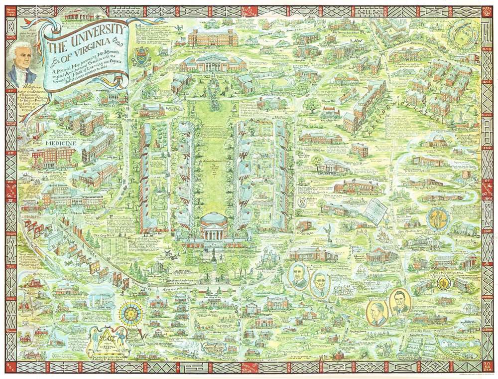

Title
The University of Virginia A Pictorial Map portraying Mr. Jefferson's original Architectural Creation with the surrounding Halls of Learning and Cognate Institutions erected to date
1960 (dated) 23.75 x 31.5 in (60.325 x 80.01 cm)
1960 (dated) 23.75 x 31.5 in (60.325 x 80.01 cm)
Description
FOR THE ORIGINAL ANTIQUE MAP, WITH HISTORICAL ANALYSIS, CLICK HERE.
Digital Map Information
Geographicus maintains an archive of high-resolution rare map scans. We scan our maps at 300 DPI or higher, with newer images being 600 DPI, (either TIFF or JPEG, depending on when the scan was done) which is most cases in suitable for enlargement and printing.
Delivery
Once you purchase our digital scan service, you will receive a download link via email - usually within seconds. Digital orders are delivered as ZIP files, an industry standard file compression protocol that any computer should be able to unpack. Some of our files are very large, and can take some time to download. Most files are saved into your computer's 'Downloads' folder. All delivery is electronic. No physical product is shipped.
Credit and Scope of Use
You can use your digial image any way you want! Our digital images are unrestricted by copyright and can be used, modified, and published freely. The textual description that accompanies the original antique map is not included in the sale of digital images and remains protected by copyright. That said, we put significant care and effort into scanning and editing these maps, and we’d appreciate a credit when possible. Should you wish to credit us, please use the following credit line:
Courtesy of Geographicus Rare Antique Maps (https://www.geographicus.com).
How Large Can I Print?
In general, at 300 DPI, you should at least be able to double the size of the actual image, more so with our 600 DPI images. So, if the original was 10 x 12 inches, you can print at 20 x 24 inches, without quality loss. If your display requirements can accommodate some loss in image quality, you can make it even larger. That being said, no quality of scan will allow you to blow up at 10 x 12 inch map to wall size without significant quality loss. For more information, it is best consult a printer or reprographics specialist.
Refunds
If the high resolution image you ordered is unavailable, we will fully refund your purchase. Otherwise, digital images scans are a service, not a tangible product, and cannot be returned or refunded once the download link is used.
Cartographer S
Louise Esther (Weibel) Britton (1900 - 1988) was an American artist. Born in the United States, she attended high school in Montreal at Montreal High School before attending McGill University. She graduated with a LLB (Bachelor of Laws) in 1922 and an LLM (Master of Laws) in 1923, although she never practiced law. She married Dr. Sydney Britton (February 24, 1892 - 19??) in 1924 and they settled in Virginia. We are aware of only 1 map issued by Britton, a pictorial map of the University of Virginia. A letter surfaced from the author's daughter pasted to the back of a framed copy of the map. The letter suggested that most copies were lost to flooding at her beach house and the original plates lost in a fire at the Richmond printing house. More by this mapmaker...
Sydney William Britton (February 24, 1892 - 19??) was a British doctor. Born in England, Britton attended McGill University in Quebec from which he received a Bachelor of Science degree in 1922 and an M.D. in 1924. He soon embarked on his medical career accepting positions at Harvard, McGill, Johnson Hopkins, and finally as a Professor of Physiology at the University of Virginia. He was awarded a Fellowship by the John Simon Guggenheim Memorial Foundation in 1937. Britton married Louise Esther Weibel in 1924 and the couple had four children: two sons and two daughters. Having taught at the University of Virginia for twenty-four years years, Dr. and Mrs. Britton relocated to Nigeria, where Dr. Britton served as a Fulbright professor in the University of West Africa. Upon retiring and returning to the U.S., the couple devoted months of research and preparation towards a historical cartograph or pictorial map of the campus of the University of Virginia, printed in 1960. Afterwards, they produced a similar map of the campus of the University of North Carolina, published in 1962, which like the University of Virginia map was printed in a small run and marketed to alumni through alumni publications. Learn More...
References
University of Virginia Library G3884 .C4:2U5 A5 1960 .E9. OCLC 70117301.