This item has been sold, but you can get on the Waitlist to be notified if another example becomes available, or purchase a digital scan.
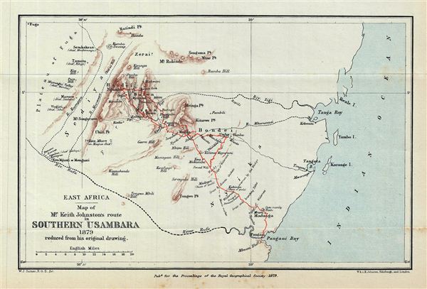
1879 Johnston Map of Southern Usambara, Tanzania, East Africa
Usambara-stanford-1879$50.00

Title
East Africa. Map of Mr. Keith Johnston's route in Southern Usambara 1879 reduced from his original drawing.
1879 (dated) 6 x 8.5 in (15.24 x 21.59 cm)
1879 (dated) 6 x 8.5 in (15.24 x 21.59 cm)
Description
This is a fascinating example of the 1879 Stanford map of southern Usambara, Tanzania, east Africa. The map follows the route of the missionary Keith Johnston (1844-1879) and details the Usambara Mountains from Fuga to the Indian Ocean. Johnston was the son of the notable english map publisher, Alexander Keith Johnston, and was commissioned to lead the Royal Geographical Society's 1879 mission to Lake Nyasa. Johnson unfortunately died during this expedition. even, parts of the expedition survived resulting in this map. Tribal lands and often the names of important African chiefs are noted. The Kumba Swamp and the Nyika plateau are identified. Various other interesting landmarks noted by the explorer, like 'Fenced Well,' 'Grass and Branching palms,' 'edge of Wilderness,' 'chain of pools,' etc. are also identified. This map was drawn by the by the missionary's grieving father, mapmaker Alexander Keith Johnston, and published by e. Stanford as part of the Proceedings of the Royal Geographical Society and Monthly Record of Geography, Vol. I, 1879.
CartographerS
Alexander Keith Johnston (December 28, 1804 - July 9, 1871) was a Scottish cartographer and map publisher active in the middle portion of the 19th century. Johnson was born at Kirkhill, near Edinburgh, Scotland. He studied at the University of Edinburgh where he apprenticed as an engraver. Around 1826, in partnership with his brother William, he founded a cartographic printing and engraving firm with the imprint "W. and A. K. Johnston." Johnston made a name for himself in educational geography, publishing numerous maps for use in schools. His brother, William Johnston, eventually left the firm to pursue a career in politics, eventually becoming the Lord Provost of Edinburgh. Alexander's son, who would bear the same name, became a geographer and explorer, suffering an untimely death on the Royal Geographical Society's 1879 expedition to Lake Nyasa. More by this mapmaker...
Edward Stanford (May 27, 1827 - November 3, 1904) was one of the most prolific map publishing firms of the late 19th century. The company began as a partnership in 1848 between the 21 year old Edward Stanford and the established map dealer Trelawney Saunders. By 1853 the partnership had dissolved and Edward Stanford took full control of the business. A subsequent series of expansions and exciting new map issues finally led to the production of Stanford's masterwork, "Stanford's Library Map of London". This map is still available and remains somewhat accurate. At the time of publishing it was hailed by the Royal Geographical Society as "the most perfect map of London that has ever been issued". In 1882 Edward Stanford Sr. passed the firm on to his son, Edward Stanford Jr. who continued in his father's proud tradition. Today the Stanford firm still publishes maps and remains one of the most important and prolific cartographic publishers in the world. Learn More...
Source
Stanford, E. Proceedings of the Royal Geographical Society and Monthly Record of Geography, Vol. 1, 1879.
Condition
Very good. Minor wear and toning on original fold lines.