Digital Image: 1859 Proeschel Gold Rush Map of Victoria, Australia
Victoria-proeschel-1859_d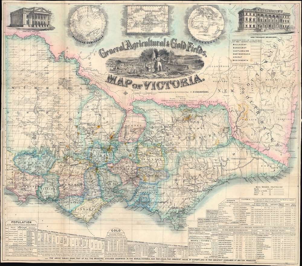

Title
General, Agricultural, and Gold Fields Map of Victoria.
1859 (undated) 18.375 x 21 in (46.6725 x 53.34 cm) 1 : 1520640
1859 (undated) 18.375 x 21 in (46.6725 x 53.34 cm) 1 : 1520640
Description
FOR THE ORIGINAL ANTIQUE MAP, WITH HISTORICAL ANALYSIS, CLICK HERE.
Digital Map Information
Geographicus maintains an archive of high-resolution rare map scans. We scan our maps at 300 DPI or higher, with newer images being 600 DPI, (either TIFF or JPEG, depending on when the scan was done) which is most cases in suitable for enlargement and printing.
Delivery
Once you purchase our digital scan service, you will receive a download link via email - usually within seconds. Digital orders are delivered as ZIP files, an industry standard file compression protocol that any computer should be able to unpack. Some of our files are very large, and can take some time to download. Most files are saved into your computer's 'Downloads' folder. All delivery is electronic. No physical product is shipped.
Credit and Scope of Use
You can use your digial image any way you want! Our digital images are unrestricted by copyright and can be used, modified, and published freely. The textual description that accompanies the original antique map is not included in the sale of digital images and remains protected by copyright. That said, we put significant care and effort into scanning and editing these maps, and we’d appreciate a credit when possible. Should you wish to credit us, please use the following credit line:
Courtesy of Geographicus Rare Antique Maps (https://www.geographicus.com).
How Large Can I Print?
In general, at 300 DPI, you should at least be able to double the size of the actual image, more so with our 600 DPI images. So, if the original was 10 x 12 inches, you can print at 20 x 24 inches, without quality loss. If your display requirements can accommodate some loss in image quality, you can make it even larger. That being said, no quality of scan will allow you to blow up at 10 x 12 inch map to wall size without significant quality loss. For more information, it is best consult a printer or reprographics specialist.
Refunds
If the high resolution image you ordered is unavailable, we will fully refund your purchase. Otherwise, digital images scans are a service, not a tangible product, and cannot be returned or refunded once the download link is used.
Cartographer S
Frederick Proeschel (March 11, 1809 - May 1, 1870) was a map maker and publisher. Born in Colmar, Haut Rhin, France, Proeschel began his professional life as an upholsterer. While working as an upholsterer, Proeschel experimented with different materials and even designed mattresses using springs. He also invented a way of manufacturing moisture-resistant bricks, which garnered him recognition from several different organizations in France. During the Revolution of 1848, Proeschel suffered substantial losses to his business, and soon left for the United States. He stayed in the U.S. until 1852 when he left for Australia, arriving in Melbourne in December of that year. By the end of July 1853, Proeschel was operating an information and labor agency in Melbourne on Little Bourke Street that operated in English, French, and German (Proeschel was fluent in all three). He also published his first map in 1853 and it detailed routes to the gold diggings in Victoria. Then he published maps of Melbourne, Collingwood, Richmond, and North Melbourne. He published his first map of Victoria in 1856. Proeschel's early maps were lithographs of modest quality. Not long after Proeschel published his first map of the gold diggings in Victoria, James Buckingham Philp (the lithographer who printed Proeschel's first work) published a new copy of Proeschel's map of the gold diggings without Proeschel's knowledge. Philp changed the title and polished the map, but it was obvious that it was copy of Proeschel's map. Proeschel was understandably furious and wrote an incensed letter to the Colonial Secretary pleading his case. Unfortunately for Proeschel, copyright law did not exist in Australia at the time, so nothing could be done to protect Proeschel's intellectual property. Then, in 1859, he published a finely engraved map of Victoria with the most up-to-date information. Several editions of this piece were published. He published his Atlas of Australasia in 1863, which cost him over three thousand pounds, a cost he likely did not recoup. While successful as a map seller, he never managed made a fortune. Proeschel left Australia in February 1864 for London to promote his work on an atlas of world exploration from the 1460s until the 1860s. Apparently this venture was unsuccessful, and he soon returned to Paris, where he again tried to promote his atlas. He published pamphlets on cholera and investment in Paris in the late 1860s and died in Paris with a mere forty francs to his name. More by this mapmaker...
James Grieve (fl. c. 1859 - c. 1871) was an engraver active in Melbourne, Australia in the mid-19th century. Grieve engraved Frederick Proeschel's map of Victoria that was first published in 1859. He also published a map of Victoria under his own imprint in 1861 that measured 3 feet 10 inches by 2 feet 8 inches. Learn More...
David Tulloch (1829 - September 17, 1869) was a Scottish-Australian engraver active in Melbourne in the mid-19th century. Tulloch emigrated from Greenock, Scotland, to Melbourne, Australia in January of 1849. It was initially employed by Thomas Harn, publisher of Harn's Illustrated Australian Magazine. In 1851, Tulloch followed prospectors to the 'gold diggings', producing some of the first on-site illustrations of the Victoria Gold Rush. In November of 1851, Tulloch established his own printing and lithography firm in Melbourne. Two years later, in 1853, he brought the map and line engraver James Davie Brown into the business. The duo produced several views and maps, receiving awards at the Victoria Industrial Exhibitions, but nonetheless dissolved their arrangement in 1856. Afterwards Tulloch fell into hard times. During his period, he produced several on-demand engravings for various Australia firms, including De Gruchy and Leigh, Fergusson and Mitchell, and Whitehead and Co. In 1859, he engraved vignettes for Frederick Proeschel's important map of Victoria In 1860, he was briefly employed by the Victoria Geological Survey, creating lithographic hachures. He filed for bankruptcy in 1861, but nothing seems to have come from it. From 1864 to 1866 he appeared in Melbourne directories as an engraver based at 91 Cecil Street, Emerald Hill (South Melbourne). On September 17, 1869, Tulloch died of pulmonary tuberculosis. Learn More...
References
OCLC 222358944, 271816317, 66901179.