Digital Image: 1963 Derveaux Map of Cheese Makers and Wineries in France
VinFromageFrance-derveaux-1963_d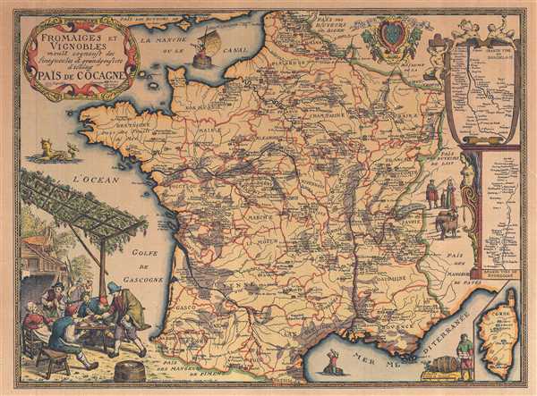

Title
Fromaiges et Vignobles.
1963 (undated) 14 x 18.75 in (35.56 x 47.625 cm) 1 : 2800000
1963 (undated) 14 x 18.75 in (35.56 x 47.625 cm) 1 : 2800000
Description
FOR THE ORIGINAL ANTIQUE MAP, WITH HISTORICAL ANALYSIS, CLICK HERE.
Digital Map Information
Geographicus maintains an archive of high-resolution rare map scans. We scan our maps at 300 DPI or higher, with newer images being 600 DPI, (either TIFF or JPEG, depending on when the scan was done) which is most cases in suitable for enlargement and printing.
Delivery
Once you purchase our digital scan service, you will receive a download link via email - usually within seconds. Digital orders are delivered as ZIP files, an industry standard file compression protocol that any computer should be able to unpack. Some of our files are very large, and can take some time to download. Most files are saved into your computer's 'Downloads' folder. All delivery is electronic. No physical product is shipped.
Credit and Scope of Use
You can use your digial image any way you want! Our digital images are unrestricted by copyright and can be used, modified, and published freely. The textual description that accompanies the original antique map is not included in the sale of digital images and remains protected by copyright. That said, we put significant care and effort into scanning and editing these maps, and we’d appreciate a credit when possible. Should you wish to credit us, please use the following credit line:
Courtesy of Geographicus Rare Antique Maps (https://www.geographicus.com).
How Large Can I Print?
In general, at 300 DPI, you should at least be able to double the size of the actual image, more so with our 600 DPI images. So, if the original was 10 x 12 inches, you can print at 20 x 24 inches, without quality loss. If your display requirements can accommodate some loss in image quality, you can make it even larger. That being said, no quality of scan will allow you to blow up at 10 x 12 inch map to wall size without significant quality loss. For more information, it is best consult a printer or reprographics specialist.
Refunds
If the high resolution image you ordered is unavailable, we will fully refund your purchase. Otherwise, digital images scans are a service, not a tangible product, and cannot be returned or refunded once the download link is used.
Cartographer
Daniel-Louis Derveaux (August 26, 1914 – November 14, 2010) was a French artist active throughout the 20th century. Derveaux was born in Paris, France. By 18 he had already become an excellent artist, mastering drawing, xylography, and copper engraving. His work is varied, but much of his early work, completed in the 1930s, involved French town and country scenes. He took part in World War II between 1936 and 1940, where he produced numerous cartoons and watercolors lampooning the war-time political environment. He began issuing maps with historical themes around 1942. Over the next 30 years he issued more than 50 geographical maps. Stylistically, Derveaux's maps are a composite of the styles developed by Blaeu and Homann, but embracing themes that would have been unusual in early maps – such as the wines and cheeses of France, the Pilgrimage to Santiago de Composetlla, the Knights Templar, the Crusades, and more. Derveaux died in his adopted home of Saint-Malo in 2010. Derveaux produced thousands of prints in his lifetime and sold them through his firm, Editions d'Art Daniel Derveaux. Daniel's son, Pierre Derveaux took over Editions d'Art Daniel Derveaux in 1982 and issued several stylistically similar maps on his own account. More by this mapmaker...