This item has been sold, but you can get on the Waitlist to be notified if another example becomes available, or purchase a digital scan.
1963 Derveaux Map of Cheese Makers and Wineries in France
VinFromageFrance-derveaux-1963$100.00

Title
Fromaiges et Vignobles.
1963 (undated) 14 x 18.75 in (35.56 x 47.625 cm) 1 : 2800000
1963 (undated) 14 x 18.75 in (35.56 x 47.625 cm) 1 : 2800000
Description
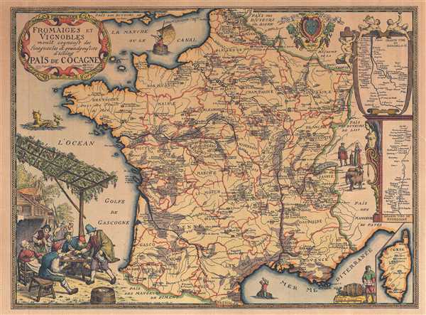
This is a 1963 Daniel-Louis Derveaux map of France, illustrating French wine and cheese producers. The map depicts the region from the English Channel and Belgium and Luxembourg to the Mediterranean Sea and from the Bay of Biscay to Germany, Switzerland, and Italy. Entitled Païs de Cocagne ('Land of Plenty'), Derveaux may also be referring to the land of Cockaigne or Cockayne, which is defined as a land of plenty in medieval myth; an imaginary place of extreme luxury and ease where physical comforts and pleasures are always immediately at hand and where the harshness of medieval peasant life does not exist. Here, the 'plenty' is most certainly French cheese and wine. French cheesemakers are labeled throughout the country, with distinctions made between cheese made with ewe's milk (blue), goat's milk (yellow), and cow's milk (brown). Nearly every region in France specializes in its own cheese, with a few exceptions.
French wine making regions, on the other hand, are noted by shading different areas of the map a darker color, almost a brown. Some of these regions are labeled, such as the Muscadet and Coteaux du Lavon regions in western France, the Crus du Jura in western France, the Vignobles du Longuedoc in southern France along the Mediterranean, and, of course, the several different wine regions around Bordeaux. Within these areas, myriad vintners (wine makers) are labeled, allowing for the vintners (and the client) to potentially locate their wineries. Two inset maps along the right border bring two wine regions into even greater focus and detail. The top inset map details the Grands Vins du Bordelais, or the Bordeaux wine region and the other regions surrounding it, stretching from St. Seurin to Bosas. The second inset map illustrates the Grand Vins de Bourgogne, or the Bourgogne wine region. This map stretches from Dijon to Villefranche, tracing a large section of the Saone River.
Aside from the numerous cheese makers and vintners labeled throughout France, several comic aspects of this map create an almost jocular air. The surrounding countries are not labeled by their internationally-recognized names (i.e. Spain, Italy, the United Kingdom), but by names like Païs de Cocagne. The United Kingdom, for example, is labeled Païs des Buveurs de Thé or 'Land of Tea Drinkers', while Germany is labeled the Roïaume de la Choucroute, the 'Kingdom of Sauerkraut'. Belgium is the Païs des Buveurs de Biere, the Country of Beer Drinkers and Italy is recognized as the Païs des Mangeurs de Pates, the Country of Pasta Eaters. Framing the map are the aforementioned inset maps of the Bordeaux and Bourgogne wine regions, along with two vignettes. One illustrates what is presumably a festival in any of the smaller towns or villages in France, celebrating wine and cheese. The other is a couple tending to their livestock and working a churn. A decorative title cartouche, in the style of 18th century French cartographers, is situated in the upper left corner.
This map was created by Daniel-Louis Derveaux in 1963.
Cartographer
Daniel-Louis Derveaux (August 26, 1914 – November 14, 2010) was a French artist active throughout the 20th century. Derveaux was born in Paris, France. By 18 he had already become an excellent artist, mastering drawing, xylography, and copper engraving. His work is varied, but much of his early work, completed in the 1930s, involved French town and country scenes. He took part in World War II between 1936 and 1940, where he produced numerous cartoons and watercolors lampooning the war-time political environment. He began issuing maps with historical themes around 1942. Over the next 30 years he issued more than 50 geographical maps. Stylistically, Derveaux's maps are a composite of the styles developed by Blaeu and Homann, but embracing themes that would have been unusual in early maps – such as the wines and cheeses of France, the Pilgrimage to Santiago de Composetlla, the Knights Templar, the Crusades, and more. Derveaux died in his adopted home of Saint-Malo in 2010. Derveaux produced thousands of prints in his lifetime and sold them through his firm, Editions d'Art Daniel Derveaux. Daniel's son, Pierre Derveaux took over Editions d'Art Daniel Derveaux in 1982 and issued several stylistically similar maps on his own account. More by this mapmaker...
Condition
Very good. Blank on verso.