This item has been sold, but you can get on the Waitlist to be notified if another example becomes available, or purchase a digital scan.
1775 Fry / Jefferson Map of Virginia and Maryland
VirginiaMaryland-fryjefferson-1775$11,000.00

Title
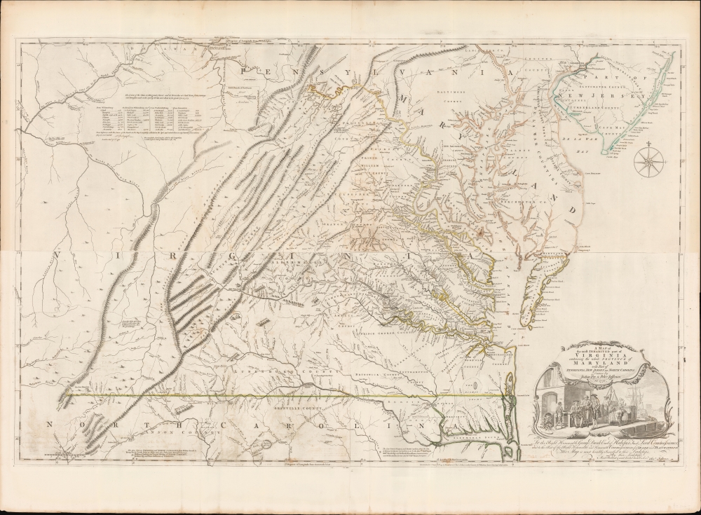
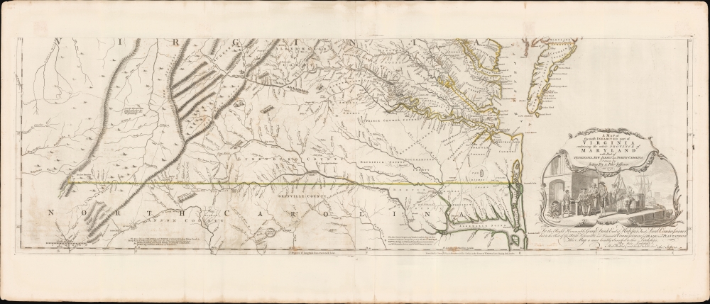
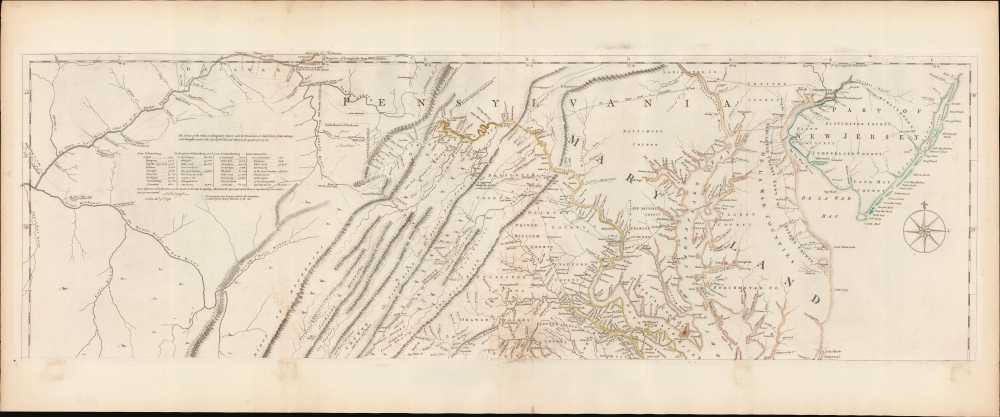
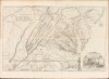
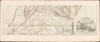
A Map of the most Inhabited part of Virginia containing the whole Province of Maryland with Part of Pensilvania, New Jersey and North Carolina drawn by Joshua Fry and Peter Jefferson in 1775.
1775 (dated) 30.75 x 48.25 in (78.105 x 122.555 cm) 1 : 650000
1775 (dated) 30.75 x 48.25 in (78.105 x 122.555 cm) 1 : 650000
Description
This is the monumental 1775 Fry/Jefferson map of Virginia and Maryland, the most important colonial map of Virginia, in its original four-sheet English version. Drawn by Joshua Fry and Peter Jefferson in 1751 and first printed in 1753, this was the first accurate survey of the interior of Virginia. It was the first printed map to approximate the parallel ridges and valleys of the Appalachian Mountains, and the first to accurately depict the Blue Ridge Mountains. Following the revision of the map in 1755, this was the first map to include Virginia's road system, also marking routes used by frontier traders and Native Americans. Following that revision, it contained the best mapping of the Upper Ohio Valley and the Virginia frontier produced during the French and Indian War (1754 - 1763) and remained the prototype for all subsequent maps of Virginia until the 19th century. As both Fry and Jefferson were denizens of the colony, this further represents the first map of Virginia produced by Virginians.
The 1750 submission to the Board of Trade of the manuscript of John Mitchell's Map of the British and French Dominions in North America revealed the uselessness of existing maps of the colonial frontier. The Board called upon colonial governors to commission improved maps to fill the gap. Virginia's governor Burwell was one of the few takers. He informed the Board of Trade, on January 15, 1751, that he had selected Joshua Fry and Peter Jefferson to produce the map. Their manuscript first draft was delivered to London December 9, 1751.
Their presentation of the Virginian interior - with its wealth of county names, roads, structures and plantations - presents the clearest view of Colonial Virginia committed to print in the 18th century. As Wooldridge points out, 'in the map's interior we see a fully developed political entity'.
In North Carolina, the map shows the addition of the upper portion of the Catawba River. It is the first map to show the Carolina Road - 'The Great Road from the Yadkin River' - which does not appear on the first state. These major revisions to the western part of the map, first included in the 1755 edition, appear also to be attributable to the efforts of Christopher Gist. At the time he was contracted by the Ohio Company, he had settled in the region of the upper Yadkin, and both it and the upper Catawba would have been familiar to him.
A Quintessential French and Indian War Map
The 1750 submission to the Board of Trade of the manuscript of John Mitchell's Map of the British and French Dominions in North America revealed the uselessness of existing maps of the colonial frontier. The Board called upon colonial governors to commission improved maps to fill the gap. Virginia's governor Burwell was one of the few takers. He informed the Board of Trade, on January 15, 1751, that he had selected Joshua Fry and Peter Jefferson to produce the map. Their manuscript first draft was delivered to London December 9, 1751.
Sources
That so little time elapsed between Fry and Jefferson's selection and their delivery of the map means that there was no time for new surveys. The mapmakers instead drew on a wealth of earlier work. Fry, with William Mayo and Robert Brooke, had already begun work on an abortive survey of the colony in 1738. Fry and Jefferson also, in 1746, surveyed Lord Fairfax's lands in the Piedmont region of Virginia. Their 1749 and 1750 surveys of Virginia's boundaries with North Carolina and Maryland were also likely incorporated. The two likely also reached out to other local surveyors whose names were not recorded. Thus, their manuscript addressed only those lands that were part of Virginia's charter, the region of the map devoted to Virginia east of the Allegheny mountains. The mapping of the neighboring colonies would have been added by Thomas Jefferys, from a variety of sources.Their presentation of the Virginian interior - with its wealth of county names, roads, structures and plantations - presents the clearest view of Colonial Virginia committed to print in the 18th century. As Wooldridge points out, 'in the map's interior we see a fully developed political entity'.
Recording the Beginning of the French and Indian War
The map's eastern sheets were updated significantly in 1755. It is believed that the edits were Fry and Jefferson's work, including the novel presentation of Virginia's road system (which does not appear on the 1753 first state). They correct several placenames and add new ones. The two western sheets, were completely reworked, in the light of an overwhelming increase of geographical knowledge for the Ohio River Valley. There appear a great many improvements, particularly to those parts west of the Blue Ridge Mountains, and to the Ohio River and its tributaries. The edited upper-left-hand sheet, in particular, presented the best delineation of the upper Ohio Valley to appear on any map published during the French and Indian War, surpassing even Lewis Evans' storied map. This can be ascribed to the contributions of frontiersman and surveyor Christopher Gist, whose firsthand mapping of the region passed directly to the Board of Trade, and ultimately Jefferys, for inclusion in this map. Gist was contracted by the Ohio Company of Virginia to survey their 1749 land grant, and as a representative of the Ohio Company was with George Washington at his May 27, 1754 defeat at Fort Necessity. Gist's information thus provided a firsthand record of the opening engagements of the French and Indian War: not only the geography delineated here, but key events at the beginning of the conflict. Firstly, the map shows the site of the November 1753 killing by Native American warriors of Robert Foyle and his family. This tragedy was a casus belli used by Virginia Lieutenant Governor Dinwiddie to support the use of military force to back up the Ohio Company's efforts to settle the frontier. Those efforts would directly result in the Virginian attack at Fort Necessity, and their defeat there at the hands of the French. The map also marks Fort du Quesne (Pittsburg), and the fort and storehouse on the Potomac of the Ohio Company.In North Carolina, the map shows the addition of the upper portion of the Catawba River. It is the first map to show the Carolina Road - 'The Great Road from the Yadkin River' - which does not appear on the first state. These major revisions to the western part of the map, first included in the 1755 edition, appear also to be attributable to the efforts of Christopher Gist. At the time he was contracted by the Ohio Company, he had settled in the region of the upper Yadkin, and both it and the upper Catawba would have been familiar to him.
The Cartouche
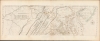
Designed by Francis Hayman and engraved by Charles Grignion, this is one of the earliest surviving pictorial representations of the Virginia tobacco trade, reflecting its dependence upon slave labor. Framed and garlanded with tobacco leaves, the cartouche presents a waterfront scene: well-heeled merchants converse, sitting and standing, while another tallies barrels for shipment. Meanwhile slaves load the barrels ons hips, while another serves drink to a seated, smoking merchant.Publication History and Census
The plates were engraved by Thomas Jefferys in 1753 based on the 1751 manuscript surveys of Joshua Fry and Peter Jefferson. The January 1755 edition of the map (third state, according to Taliaferro) saw significant changes made to each plate. The present example is Taliaferro's state 7, printed for inclusion in Jefferys' 1775 The North American Atlas, published by Robert Sayer in 1775. All states of this map are scarce, with earlier states rarer than later. We see six examples of this 1775 state cataloged in institutional collections.CartographerS
Joshua Fry (1699–1754) was an English adventurer, professor, investor who became an official in the colony of Virginia. He is best known as a surveyor and cartographer who collaborated with Peter Jefferson, the father of future U.S. president Thomas Jefferson in producing the quintessential colonial map of Virginia and Maryland.
Fry was born in Somerset, England, and educated at Oxford. He sought his fortune in the colonies, emigrating to Virginia in 1726. There he would marry and raise a large family. He would become a professor of mathematics and natural philosophy. After marrying a young widow, he would give up his professorship to operate her plantation. At that time he would begin a public career as a judge but would also buy and sell real estate, and worked as well as a surveyor. In 1746 Fry and Peter Jefferson were commissioned to survey Lord Fairfax's lands in the Piedmont region of Virginia, and three years later the two were tasked with surveying the boundary with North Carolina. In 1750 they would be assigned to survey the border with Maryland as well. On the strength of these and other surveys, Fry and Jefferson would produce their 1751 masterpiece map, A Map of the most Inhabited part of Virginia containing the whole Province of Maryland. Fry had served as colonel in Albemarle County's militia, and at the beginning of the French and Indian War he was named Commander-in-Chief of colonial forces, given command of the Virginia Regiment, and ordered to capture Fort Duquesne from the French. On the way, he fell from his horse and died from the resultant injuries. He was succeeded in command of the Virginia Regiment by a young officer named George Washington. More by this mapmaker...
Peter Jefferson (February 29, 1708 - August 17, 1757) was a planter, cartographer and politician best known as the father of US President Thomas Jefferson (1743–1826). In collaboration with surveyor Joshua Fry, he produced in 1751 the so-called 'Fry-Jefferson Map'. Jefferson was born in the Virginia Colony at Osbornes on the James River, the son of a large property owner. He received no formal education in his youth, but was a well-read autodidact. He inherited land, becoming a prosperous plantation owner, slave owner, sheriff, surveyor and justice of the peace. He was also a surveyor and mapmaker: in 1749 he collaborated with Joshua Fry in the production of their 1751 A Map of the most Inhabited part of Virginia containing the whole Province of Maryland, which accurately depicted the Allegheny Mountains for the first time and showed the route of what would later be known as the Great Wagon Road. Learn More...
Thomas Jefferys (1695 - November 20, 1771) was one of the most prominent and prolific map publishers and engravers of his day. Jefferys was born in Birmingham and was apprenticed to the engraver Emmanuel Bowen in 1735. Later, in the 1740s he engraved several maps for the popular periodical Gentleman's Magazine. Around 1740 Jefferys was finally able to go into business for himself and in 1746 received an appointment as 'Geographer to Fredrick, Prince of Wales,' which shortly after translated to the position of 'Royal Cartographer to King George III.' Jefferys initially specialized in compiling and re-engraving the works of earlier cartographers into more coherent cartographic wholes. Later, while not salaried position, Jefferys' appointment as 'Royal Cartographer' guaranteed preferential access to the most up to date cartographic material available, allowing him to produce new and updated charts of exceptional accuracy. He his best known for his maps of the Americas, particularly the posthumously published 1775 American Atlas, which included some of the finest and most important late colonial era maps of America ever made. Despite his prolific publishing history, royal appointments, and international publishing fame, Jefferys lived most of his life in dire economic straits. He was bailed out of bankruptcy by Robert Sayer during the production of the American Atlas. In the end, Jefferys died suddenly with very little to his name. Nonetheless, his cartographic legacy survived, and even after his death in 1771, many of his important maps continued to be published and republished by Sayer and Bennet, Conrad Lotter, Georges Louis Le Rouge, Laurie and Whittle, and others. Many attribute some of Jefferys best maps to the colorful and criminally inclined Irish cartographic genius Braddock Mead (John Green, c. 1688 - 1757), who is considered the 'secret behind Jefferys.' Jefferys was succeeded by his son, also Thomas, who had little success as a cartographer and eventually partnered with, then sold his stock and plates to William Faden - Jefferys' true heir. Learn More...
Christopher Gist (1706–1759) was an explorer, surveyor, and frontiersman in Colonial America. He was one of the first English explorers of the Ohio River valley, and provided the first detailed description of that country to colonists in the Thirteen Colonies. Little is known of his education as a surveyor, which was probably received from his father Richard Gist, who helped lay out the plan for the city of Baltimore. By 1750 Gist had settled in northern North Carolina near the Yadkin River; that year, he was hired by the Ohio Company to explore the Ohio Country as far as the present location of Louisville, Kentucky; he mapped Ohio betweeen the present day location of Pittsburgh to the Miami River. In 1753 he accompanied George Washington on his mission to convince the French to abandon Ohio; during their travels on this futile effort, Gist saved Washington's life twice - once from drowning in the frozen Allegheny River, and once from Indian attack.
In 1754 Gist accompanied Washington and the Virginia Regiment in their attempt to forcibly drive the French from Ohio, resulting in their defeat at the hands of the French at Fort Necessity. Gist was also part of the Braddock Expedition during its 1755 defeat by the French and their Native American allies. Gist died in 1759, either in Carolina or Georgia, of smallpox. Learn More...
Source
Sayer, R., Bennett, J., and Jefferys, T., The American Atlas: Or, A Geographical Description Of The Whole Continent Of America ... Engraved On Forty-Eight Copper Plates, By The Late Mr. Thomas Jefferys, Geographer to the King, and Others, (London: Sayer and Bennett) 1776.
Thomas Jefferys' The American Atlas is among the most important atlases of American issued during and after the American Revolutionary War (1775 - 1783). Burden calls it 'arguably the first American 'state' atlas' and Ristow writes, it is a '… major cartographic reference work it was very likely consulted by American, English and French civilian administrators and military officers during the Revolution…' It was first published in 1775, with updates following in 1776, 1778, 1782, 1794, and 1800. All editions are notably postdate Jefferys himself, who died in 1771. The application of his name to the The American Atlas is mostly an honorific - though most of the constituent maps can be traced to Jefferys' work. After Jefferys' death, his map plates were acquired by his partner, printseller Robert Sayer. By the mid-1770s Sayer had taken on John Bennett as a partner. Together, they compiled and updated many of Jefferys' map, published as the to capitalize on interest in America associated with the Revolution. Maps from the The American Atlas exhbit is considerable date variation, with some featuring dates later than the title page, suggesting that many were updated by owners in subsequent years, and/or that the title page was reused for latter editions.
Condition
Very good. Printed to four sheets and joined in upper and lower sections for publication. Original outline color. Few marginal mends well away from printed area, else excellent. Size is for printed area, if joined. Wide margins all around.
References
OCLC 923019729. Rumsey 0346.025. Taliaferro, H. 'Fry and Jefferson Revisited' MESDA Journal 2013. Stephenson and McKee, Virginia in Maps, pp. 83-87. Cumming, The Southeast in Early Maps, no. 281. Coolie Verner, Coolie 'The Fry and Jefferson Map', Imago Mundi XXI, pp. 70-94. Wooldridge, W. Mapping Virginia pp. 107-121.