Digital Image: 1874 Windwart Map of the West Village, Union Square, New York City
WestVillageUnionSquare-windwart-1875_d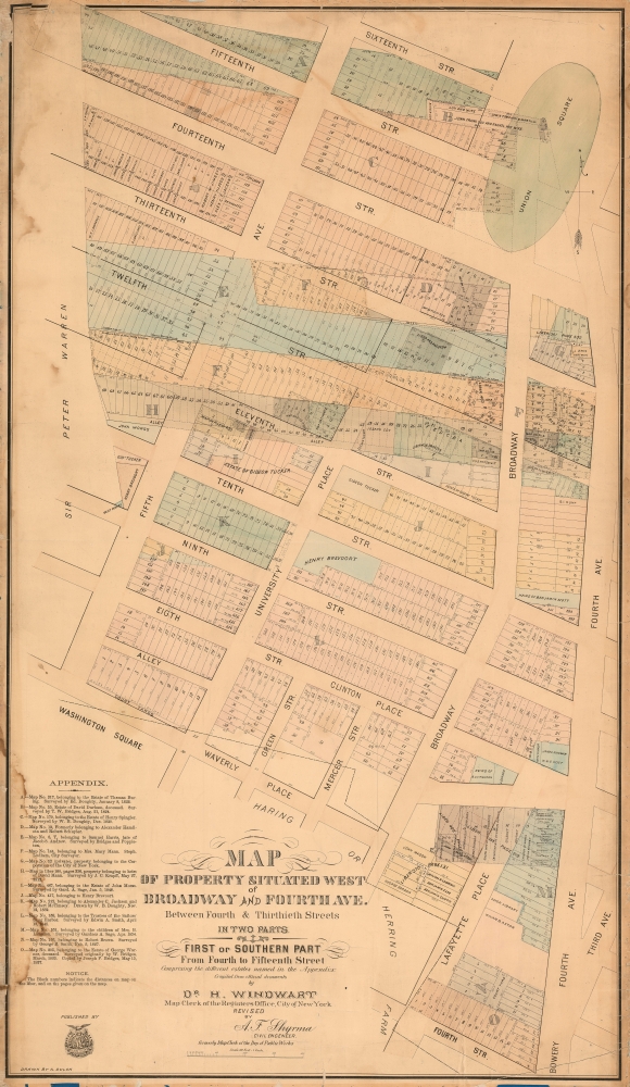


Title
Map of Property Situated West of Broadway and Fourth Ave. Between Fourth and Thitieth Streets in Two Parts. / First or Southern Part From Fourth to Fifteenth Street.
1875 (undated) 36.5 x 21 in (92.71 x 53.34 cm) 1 : 12000
1875 (undated) 36.5 x 21 in (92.71 x 53.34 cm) 1 : 12000
Description
FOR THE ORIGINAL ANTIQUE MAP, WITH HISTORICAL ANALYSIS, CLICK HERE.
Digital Map Information
Geographicus maintains an archive of high-resolution rare map scans. We scan our maps at 300 DPI or higher, with newer images being 600 DPI, (either TIFF or JPEG, depending on when the scan was done) which is most cases in suitable for enlargement and printing.
Delivery
Once you purchase our digital scan service, you will receive a download link via email - usually within seconds. Digital orders are delivered as ZIP files, an industry standard file compression protocol that any computer should be able to unpack. Some of our files are very large, and can take some time to download. Most files are saved into your computer's 'Downloads' folder. All delivery is electronic. No physical product is shipped.
Credit and Scope of Use
You can use your digial image any way you want! Our digital images are unrestricted by copyright and can be used, modified, and published freely. The textual description that accompanies the original antique map is not included in the sale of digital images and remains protected by copyright. That said, we put significant care and effort into scanning and editing these maps, and we’d appreciate a credit when possible. Should you wish to credit us, please use the following credit line:
Courtesy of Geographicus Rare Antique Maps (https://www.geographicus.com).
How Large Can I Print?
In general, at 300 DPI, you should at least be able to double the size of the actual image, more so with our 600 DPI images. So, if the original was 10 x 12 inches, you can print at 20 x 24 inches, without quality loss. If your display requirements can accommodate some loss in image quality, you can make it even larger. That being said, no quality of scan will allow you to blow up at 10 x 12 inch map to wall size without significant quality loss. For more information, it is best consult a printer or reprographics specialist.
Refunds
If the high resolution image you ordered is unavailable, we will fully refund your purchase. Otherwise, digital images scans are a service, not a tangible product, and cannot be returned or refunded once the download link is used.
Cartographer S
Heinrich Windwart (July 12, 1810 - April 30, 1881) was a German civil servant, revolutionary, medical doctor, and map publisher. He was born in Bavaria and studied at the University of Jena. He was heavily involved in the German Revolutions of 1848. When the revolutions were suppressed, he went into exile, first in Switzerland, then France, and ultimately, in 1853, to the United States. He initially settled in Baltimore, but moved to New York in the 1860s when his fellow German 'Forty-Eighter,' Franz Sigel (1824 - 1902), was elected Registrar of New York City, and offered him a clerk position. Windwart was one of several map publishers, the most famous of whom was John Bute Holmes, who was able to leverage cartographic skill to capitalize on the New York City transition from grand 18th century estates to the meticulously gridded and plotted structure of the Commissioner's Plan. More by this mapmaker...
Arnold Dulon (1843 - August 14, 1929) was a city surveyor and topographical draftsman in the service of the city of New York in the late 19th and early 20th centuries. Dulon was born in Germany and, fleeing the unrest associated with the Revolutions of 1848, emigrated to the United States, arriving in Ellis Island on September 30, 1853. Dulon served in the Union army during the American Civil War from 1862 to 1863. Following the war, he was in the employ of the city of New York for more than 20 years: 1872 - 1875 Registrar's Office, 1894 - 1897 Commissioner of Street Improvements, 1898 - 1901 Board of Public Improvements, 1902 - 1915 Topographical Draftsman for the Bronx. He applied for retirement in 1915, citing that at his advanced age, 73, he was physically incapable of performing his duties. After retiring Dulon moved to California, living in Solano from 1918 until 1928. Learn More...
Joseph P. Laing (1828 - 1905) was a Scottish printer and engraver active in New York during the middle part of the 20th century. Laing was born in Edinburgh, Scotland, and apprenticed as an engraver under W. H. Lizars. He emigrated to the United States in 1845, taking work with the firm of Snyder and Black. Afterwards, in 1850, Laing established himself as a private engraver and publisher at 25 Fulton Street. He also became a naturalized U.S. Citizen in 1852. In 1861, at the outbreak of the American Civil War he enlisted as a Captain in the Union Army, 79th Regiment, Scotch Highlanders. During his service, he was wounded eight times and captured (and escaped) twice. He fought at the Battle of Bull Run. Sometime during the war, he partnered with William Lang, and relocated his shop to 117 Fulton Street, which also, during this period, served as a Union Army recruiting office. Laing's partnership with Lang dissolved in 1862 but he continued to print under his own imprint until at least 1889. He was also a Mason of the Scottish Rite, a Major of the New York State National Guard, and was active with the Burns Club. Learn More...
Alexander F. Shyrma (1842 - ????) was a Polish-American New York City based civil engineer, inventor, and surveyor active in the late 19th century. In 1873 Shyrma invented and patented a technique for layout cement pavement. He married Elizabeth Jane Wingrove in 1868. In the early 1870s he was a Map Clerk at the New York City Department of Public Works. Learn More...
References
OCLC 50557119. Phillips (America) p. 539.