Digital Image: 1928 National Geographic Society and Wyeth Print of Western Hemisphere Mural
WesternHemisphere-wyeth-1928_d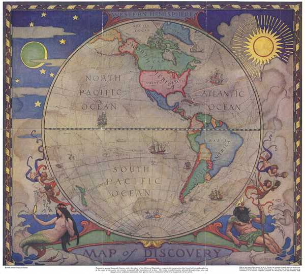

Title
Map of Discovery - Western Hemisphere.
1929 (dated 1928) 16.5 x 18.25 in (41.91 x 46.355 cm) 1 : 55730000
1929 (dated 1928) 16.5 x 18.25 in (41.91 x 46.355 cm) 1 : 55730000
Description
FOR THE ORIGINAL ANTIQUE MAP, WITH HISTORICAL ANALYSIS, CLICK HERE.
Digital Map Information
Geographicus maintains an archive of high-resolution rare map scans. We scan our maps at 300 DPI or higher, with newer images being 600 DPI, (either TIFF or JPEG, depending on when the scan was done) which is most cases in suitable for enlargement and printing.
Delivery
Once you purchase our digital scan service, you will receive a download link via email - usually within seconds. Digital orders are delivered as ZIP files, an industry standard file compression protocol that any computer should be able to unpack. Some of our files are very large, and can take some time to download. Most files are saved into your computer's 'Downloads' folder. All delivery is electronic. No physical product is shipped.
Credit and Scope of Use
You can use your digial image any way you want! Our digital images are unrestricted by copyright and can be used, modified, and published freely. The textual description that accompanies the original antique map is not included in the sale of digital images and remains protected by copyright. That said, we put significant care and effort into scanning and editing these maps, and we’d appreciate a credit when possible. Should you wish to credit us, please use the following credit line:
Courtesy of Geographicus Rare Antique Maps (https://www.geographicus.com).
How Large Can I Print?
In general, at 300 DPI, you should at least be able to double the size of the actual image, more so with our 600 DPI images. So, if the original was 10 x 12 inches, you can print at 20 x 24 inches, without quality loss. If your display requirements can accommodate some loss in image quality, you can make it even larger. That being said, no quality of scan will allow you to blow up at 10 x 12 inch map to wall size without significant quality loss. For more information, it is best consult a printer or reprographics specialist.
Refunds
If the high resolution image you ordered is unavailable, we will fully refund your purchase. Otherwise, digital images scans are a service, not a tangible product, and cannot be returned or refunded once the download link is used.
Cartographer
Newell Convers Wyeth (October 22, 1882 - October 19, 1945), known as N. C. Wyeth, was an American artist and illustrator. Born in Needham, Massachusetts, Wyeth was the oldest of four brothers. These brothers spent most of their time hunting, fishing, and doing chores around their farm. His mother was acquainted with Henry David Thoreau and Henry Wadsworth Longfellow, and she encouraged his artistic pursuits and talents from an early age. Wyeth was creating excellent watercolor paintings by the age of twelve. He attended Mechanics Arts School to learn drafting, and then Massachusetts Normal Art School (now the Massachusetts College of Art and Design)where Richard Andrew, his painting instructor, advised him to become an illustrator. He then attended the Eric Pape School of Art to learn illustration, under the tutelage of George Loftus Noyes and Charles W. Reed. He was accepted into Howard Pyle’s School of Art in Wilmington, Delaware and Chadds Ford, Pennsylvania, in 1902, after being encouraged to apply by two friends who had been admitted the year before. He was accepted and immediately meshed with Pyle’s methods and ideals. Wyeth was a standout student who admired great literature, music, and drama, and enjoyed spirited conversation. Wyeth’s first commission as an illustrator, a bucking bronco, appeared on the cover of the February 21, 1903 issue of The Saturday Evening Post. In 1904, Wyeth was commissioned by that same magazine to illustrate a Western story. At Pyle’s urging, Wyeth traveled west, where he worked as a cowboy in Colorado alongside professional ‘pushers’, moving cattle and doing ranch chores. In Arizona, he visited the Navajo and came away with an understanding of Native American culture. He married Carolyn Bockius of Wilmington and they settled in Chadds Ford in 1908 on a farm near the Brandywine battlefield. Wyeth and Carolyn had five children and created a stimulating household, where frequent visitors included F. Scott Fitzgerald, Joseph Hergesheimer, Lilian Gish, and John Gilbert.In 1911, Wyeth illustrated an edition of Treasure Island by Robert Louis Stevenson, with the proceeds from this project paying for his house and studio. He also illustrated editions of Robin Hood, The Last of the Mohicans, Robinson Crusoe, and Rip Van Winkle, along with several others. He also produced posters for clients, including Lucky Strike, Cream of Wheat, and Coca-Cola, along with paintings of Beethoven, Wagner, and Liszt for Steinway and Sons. He also painted historical and allegorical murals for the First National Bank of Boston, the Federal Reserve Bank of Boston, the Hotel Roosevelt, the National Geographic Society, and other private and public buildings. Also, he created patriotic posters for government and private entities during both world wars. Wyeth and his grandson were killed when the automobile they were riding in was struck by a freight train in 1945. More by this mapmaker...
Source
Wyeth, N.C., 'Map of Discovery- Western Hemisphere', National Geographic Magazine Vol. LV, No. 1, January 1929.
References
Rumsey 8825.000.