Digital Image: 1869 Gaylord Watson Map of the Western United States
WesternStates-watson-1869_d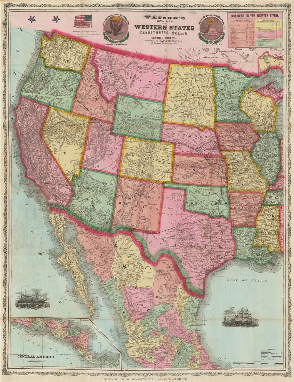


Title
Watson's New Map of the Western States Territories, Mexico and Central America.
1869 (dated) 38.5 x 29.75 in (97.79 x 75.565 cm) 1 : 4500000
1869 (dated) 38.5 x 29.75 in (97.79 x 75.565 cm) 1 : 4500000
Description
FOR THE ORIGINAL ANTIQUE MAP, WITH HISTORICAL ANALYSIS, CLICK HERE.
Digital Map Information
Geographicus maintains an archive of high-resolution rare map scans. We scan our maps at 300 DPI or higher, with newer images being 600 DPI, (either TIFF or JPEG, depending on when the scan was done) which is most cases in suitable for enlargement and printing.
Delivery
Once you purchase our digital scan service, you will receive a download link via email - usually within seconds. Digital orders are delivered as ZIP files, an industry standard file compression protocol that any computer should be able to unpack. Some of our files are very large, and can take some time to download. Most files are saved into your computer's 'Downloads' folder. All delivery is electronic. No physical product is shipped.
Credit and Scope of Use
You can use your digial image any way you want! Our digital images are unrestricted by copyright and can be used, modified, and published freely. The textual description that accompanies the original antique map is not included in the sale of digital images and remains protected by copyright. That said, we put significant care and effort into scanning and editing these maps, and we’d appreciate a credit when possible. Should you wish to credit us, please use the following credit line:
Courtesy of Geographicus Rare Antique Maps (https://www.geographicus.com).
How Large Can I Print?
In general, at 300 DPI, you should at least be able to double the size of the actual image, more so with our 600 DPI images. So, if the original was 10 x 12 inches, you can print at 20 x 24 inches, without quality loss. If your display requirements can accommodate some loss in image quality, you can make it even larger. That being said, no quality of scan will allow you to blow up at 10 x 12 inch map to wall size without significant quality loss. For more information, it is best consult a printer or reprographics specialist.
Refunds
If the high resolution image you ordered is unavailable, we will fully refund your purchase. Otherwise, digital images scans are a service, not a tangible product, and cannot be returned or refunded once the download link is used.
Cartographer
Gaylord Watson (September 23, 1833 - October 10, 1896) was an American map publisher and engraver based in New York City. Watson briefly partnered with his uncle Humphrey Phelps as Phelps and Watson (1859 - January 1, 1865) with offices at 16 Beekman Street, New York. After 1864 he established his own imprint, now at 61 Beekman. Watson focused on highly decorative emigrant guides, wall maps, and railroad maps. Around 1871 Watson established a branch office in Chicago under the management of D. Needham at no. 66 Lake Street. In 1881 a fire destroyed Watson's offices at 61 Beekman Street, pushing him into deep financial stress. A notice appearing in Publisher's Weekly, 1893, reads, 'Gaylord Watson, map publisher, has been sold out by the sheriff. The sale realized about $800', suggesting that Watson had either died or fallen into bankruptcy. Watson lived in Queens, then Brooklyn, and in 1894, shortly before his death, Omaha, Nebraska. More by this mapmaker...
References
OCLC 773575545. Rumsey 1176.001. Wheat (America) 1174.