Digital Image: 1885 Eastman Pocket Map of the White Mountains, New Hampshire
WhiteMountains-eastman-1885_d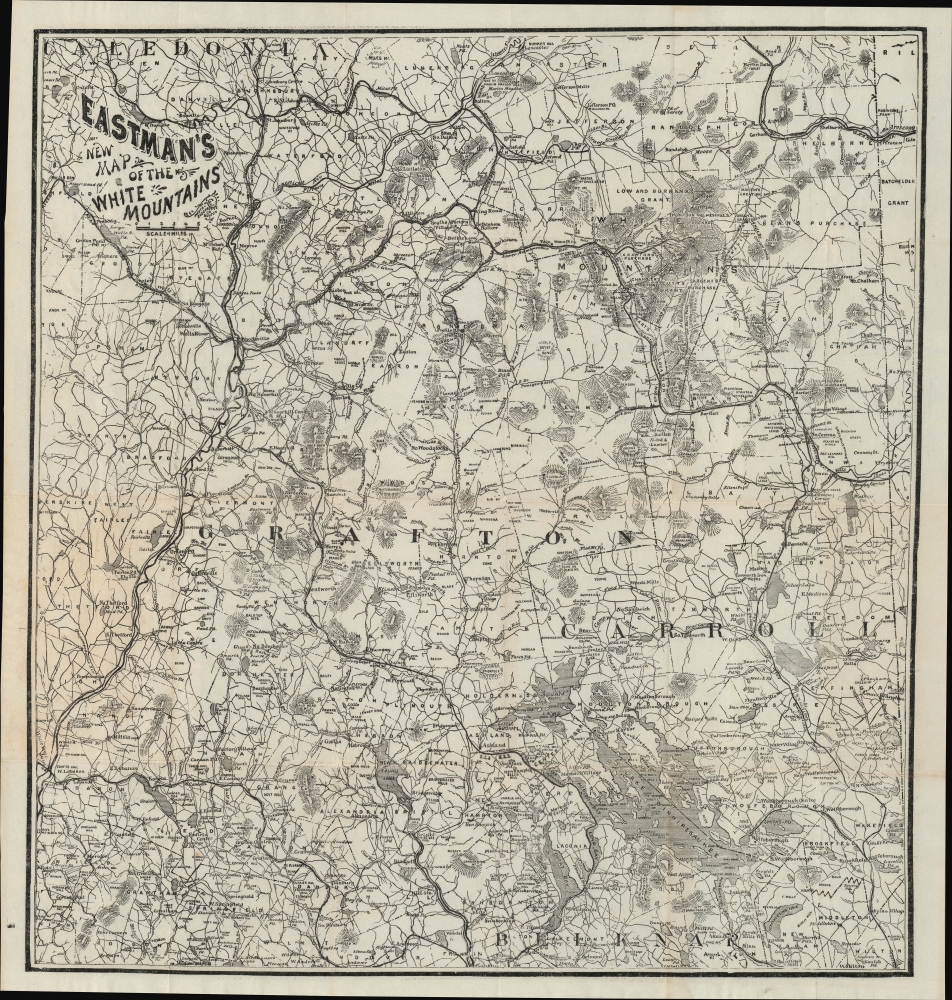

Title
Eastman's New Map of the White Mountains.
1885 (undated) 18.25 x 17.25 in (46.355 x 43.815 cm) 1 : 260000
1885 (undated) 18.25 x 17.25 in (46.355 x 43.815 cm) 1 : 260000
Description
FOR THE ORIGINAL ANTIQUE MAP, WITH HISTORICAL ANALYSIS, CLICK HERE.
Digital Map Information
Geographicus maintains an archive of high-resolution rare map scans. We scan our maps at 300 DPI or higher, with newer images being 600 DPI, (either TIFF or JPEG, depending on when the scan was done) which is most cases in suitable for enlargement and printing.
Delivery
Once you purchase our digital scan service, you will receive a download link via email - usually within seconds. Digital orders are delivered as ZIP files, an industry standard file compression protocol that any computer should be able to unpack. Some of our files are very large, and can take some time to download. Most files are saved into your computer's 'Downloads' folder. All delivery is electronic. No physical product is shipped.
Credit and Scope of Use
You can use your digial image any way you want! Our digital images are unrestricted by copyright and can be used, modified, and published freely. The textual description that accompanies the original antique map is not included in the sale of digital images and remains protected by copyright. That said, we put significant care and effort into scanning and editing these maps, and we’d appreciate a credit when possible. Should you wish to credit us, please use the following credit line:
Courtesy of Geographicus Rare Antique Maps (https://www.geographicus.com).
How Large Can I Print?
In general, at 300 DPI, you should at least be able to double the size of the actual image, more so with our 600 DPI images. So, if the original was 10 x 12 inches, you can print at 20 x 24 inches, without quality loss. If your display requirements can accommodate some loss in image quality, you can make it even larger. That being said, no quality of scan will allow you to blow up at 10 x 12 inch map to wall size without significant quality loss. For more information, it is best consult a printer or reprographics specialist.
Refunds
If the high resolution image you ordered is unavailable, we will fully refund your purchase. Otherwise, digital images scans are a service, not a tangible product, and cannot be returned or refunded once the download link is used.
Cartographer S
Edison C. Eastman (c. 1832 - 1911), also as Edson, was a publisher of guidebooks and maps of the White Mountains region of New Hampshire in the late 19th and early 20th centuries. Government records indicate that he spent most of his life in Concord, New Hampshire, with his occupation listed variously as publisher, bookseller, or bookkeeper. He also served in the Union Army during the U.S. Civil War. More by this mapmaker...
James Henry Stark (July 6, 1846 - August 30, 1919) was an American publisher active in the late 19th and early 20th centuries. Stark was born in Mutcham, Surrey, England. As a young man in England he was raised by Thomas Cook, the famous English travel agent. He moved to the United States in 1856, when he was 9 or 10. In the United States, he studied at Hawes Grammar School in South Boston, and later attended the Lincoln School and the Boston Latin School. He began studying printing, particularly stereotyping and electrotyping, in 1864. In 1870 he established himself as a printer at the corner of Water and Congress Streets. He prospered until the Great Boston Fire of 1872, when his establishment burnt to the ground. After the fire, he turned his attention to yachting, suggesting access to considerable wealth, and sailed from Boston to the Caribbean and to South America, where he prospected for and discovered gold in Dutch Giana. He eventually returned to Boston, where he once again went into the printing business, establishing a stereotype and electrotype foundry at 1717 Devonshire Street. Stark partnered with William H. Mumler (1832 - 1884) in 1877 to found the Photo-Electrotype Company, one of the earliest American photolithography companies. Stark sold his shares of the company in 1900 and turned to Real Estate. Through his interest in Yachting and Caribbean travel, and possibly influenced by his connected to Thomas Cook, Start also had a successful business composing and writing guidebooks for various West India Islands. He also issued the Stranger's Guide to Boston. Learn More...
References
Beinecke Library Call No. 762 W588 1870.