1646 Joan Blaeu County Map of Wiltshire, Noting Stonehenge
Wiltshire-blaeu-1645$500.00

Title
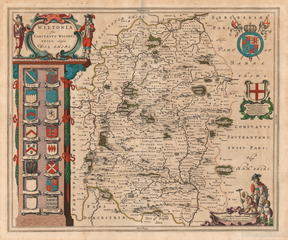
Wiltonia sive Comitatus Wiltoniensis; Anglis Wilshire.
1645 (undated) 16.25 x 19.5 in (41.275 x 49.53 cm) 1 : 220000
1645 (undated) 16.25 x 19.5 in (41.275 x 49.53 cm) 1 : 220000
Description
This is Joan Blaeu's 1645 map of the county of Wiltshire in southwestern England. While not the first atlas map to detail the county (this honor goes to Speed's map, from which Blaeu's is derived), it is among the most beautifully engraved and colored.
The Civil War
When Blaeu's Atlas of England (the fourth volume of his Atlas Novus) was published, its subject was in the grip of the English Civil War (1642 - 1651). In the early years of the war, the Dutch were split in their support of England: dynastic connections tended towards Orangist support of Charles I of the House of Stuart, while the mercantile elites of Holland tended to support the Parliamentarians. The content of the map, dating from Speed's 1610 map of the county, does not reflect the current battles. The martial figures decorating the map's cartouche and scales, however, wear the distinctive rich garb of the Royalist Cavaliers, in spite of Wiltshire having been at the time mainly a Parliamentarian stronghold. Moreover, the upper right corner is embellished with the coat of arms of Charles I. Thus, the décor of the map reflects less the situation on the ground, and more Blaeu's attitude towards it (or his perception of his patrons' attitude).Attention to Speed's Detail
As befits a meticulous copy of Speed's cartography, the map is richly detailed, showing towns, abbeys, castles, forests, and parklands. The countryside's hilly terrain is shown pictorially. Also derived from Speed's map is the columnar design at the left, containing fourteen coats-of-arms, belonging to the Earls of Wilshire and Salisbury. The last of these is that of Robert Cecil, the first Earl of Salisbury, who died during Speed's lifetime. There are two additional spaces for arms, but Blaeu has not seen fit to update them.Hewn Into the Living Rock
As wondrous in the 17th century as now, Stonehenge figures prominently. It is named and shown pictorially, west of Amesbury (Ambersbury). A cartouche to the right (embellished with the cross of Saint George) references a pseudohistory relating the monument, claiming Stonehenge to have been the burial place in CE 500 of the legendary uncle of King Arthur, Ambrosius Aurelianus. (Radiocarbon dating suggests that the first stones were raised between 2400 and 2200 BCE, but alas, 17th-century scholars had only Geoffrey of Monmouth's Historia Regum Britanniae to go by.) The text of the cartouche also notes that King Arthur's father, Uther Pendragon, was also buried there in 517, as well as 'Constanc, King of Britanie' in 546.Publication History and Census
This map was engraved in about 1645 for inclusion in Joan Blaeu's Atlas Novus. It does not appear to have been included in the Atlas Maior. This example conforms typographically with the 1646 Latin edition of the atlas. The map is well represented in institutional collections in various editions.CartographerS
Joan (Johannes) Blaeu (September 23, 1596 - December 21, 1673) was a Dutch cartographer active in the 17th century. Joan was the son of Willem Janszoon Blaeu, founder of the Blaeu firm. Like his father Willem, Johannes was born in Alkmaar, North Holland. He studied Law, attaining a doctorate, before moving to Amsterdam to join the family mapmaking business. In 1633, Willem arranged for Johannes to take over Hessel Gerritsz's position as the official chartmaker of the Dutch East India Company, although little is known of his work for that organization, which was by contract and oath secretive. What is known is his work supplying the fabulously wealthy VOC with charts was exceedingly profitable. Where other cartographers often fell into financial ruin, the Blaeu firm thrived. It was most likely those profits that allowed the firm to publish the Theatrum Orbis Terrarum, sive, Atlas Novus, their most significant and best-known publication. When Willem Blaeu died in 1638, Johannes, along with his brother Cornelius Blaeu (1616 - 1648) took over the management of the Blaeu firm. In 1662, Joan and Cornelius produced a vastly expanded and updated work, the Atlas Maior, whose handful of editions ranged from 9 to an astonishing 12 volumes. Under the brothers' capable management, the firm continued to prosper until the 1672 Great Amsterdam Fire destroyed their offices and most of their printing plates. Johannes Blaeu, witnessing the destruction of his life's work, died in despondence the following year. He is buried in the Dutch Reformist cemetery of Westerkerk. Johannes Blaeu was survived by his son, also Johannes but commonly called Joan II, who inherited the family's VOC contract, for whom he compiled maps until 1712. More by this mapmaker...
John Speed (1542 - 1629) was an important English historian and cartographer active in the early 17th century. Speed was born in Fardon, Cheshire and apprenticed under his father as a tailor. Though his heart was never in tailoring, Speed dedicated himself to this profession until he was about 50 years old. During all the time, Speed dedicated his spare time to research as amateur historian and mapmaker - even preparing several maps for Queen Elizabeth. In London, Speed's interest in history lead him to join the Society of Antiquaries. Eventually he befriended the wealthy Sir Fulke Greville, who sponsored his researches and eventually freed him from the haberdashery profession. Working with William Camden, Speed eventually published his 1611 Historie of Great Britaine. Though this history itself was amateurish and of minimal importance, Speed's inclusion of numerous maps of British Cities and town was seminal. In many cases these plans were the first maps ever issued of their respective subjects. Later, turning his attention more fully to Geography, Speed published the magnificent atlas Theatre of the Empire of Great Britaine and, just prior to his death, the 1627 A Prospect of the Most Famous Parts of the World. These were the first British world atlases and have a landmark position in the history of cartography. These atlases continued to be published well after Speed's death. Learn More...
Source
Blaeu, J., Théâtre du Monde ou Nouvel Atlas, (Amsterdam: Blaeu) 1646.
The classic Dutch atlas, whose publication ushered in the Dutch golden age of cartography. Willem Jansz Blaeu had been, since 1604, producing engraved maps for sale; these were separate issues (and all consequently extremely rare) until the publishing of Blaeu's Appendix in 1630 and 1631, which also included a number of maps purchased from the widow of Jodocus Hondius, (for example his famous iteration of John Smith's map of Virginia.) In 1634, he announced his intention to produce a new world atlas in two volumes, entitled Theatrum Orbis Terrarum, sive Atlas Novus (Théâtre du Monde ou Nouvel Atlas) (in an effort to invoke the successful work of the same title produced by Ortelius the previous century, while reinforcing the notion of it being a new work.) This work was published first in German in 1634, followed by Latin, Dutch and French editions in 1635. Blaeu's maps have always been noted for the quality of their paper, engraving and fine coloring, and this was the intent from the very start. The 1634 announcement of the upcoming work described it: 'All editions on very fine paper, completely renewed with newly engraved copperplates and new, comprehensive descriptions.' (van der Krogt, p,43) Many of the most beautiful and desirable maps available to the modern collector were printed and bound in Blaeu's atlases. Willem's son, Joan, would go on to add further volumes to the Atlas Novus, concurrently printing new editions of the first two volumes with additional maps, in effect making these new editions an entirely new book. Under Joan there would be nine Latin editions, twelve French, at least seven Dutch, and two German. This exceedingly successful work would be the mainstay of the Blaeu firm until 1661, at which point the work was supplanted by Joan Blaeu's masterwork Atlas Maior in 1662.
Condition
Very good. Gentle toning; else excellent condition with beautiful original color.
References
Rumsey 12058.038. OCLC 611362090.