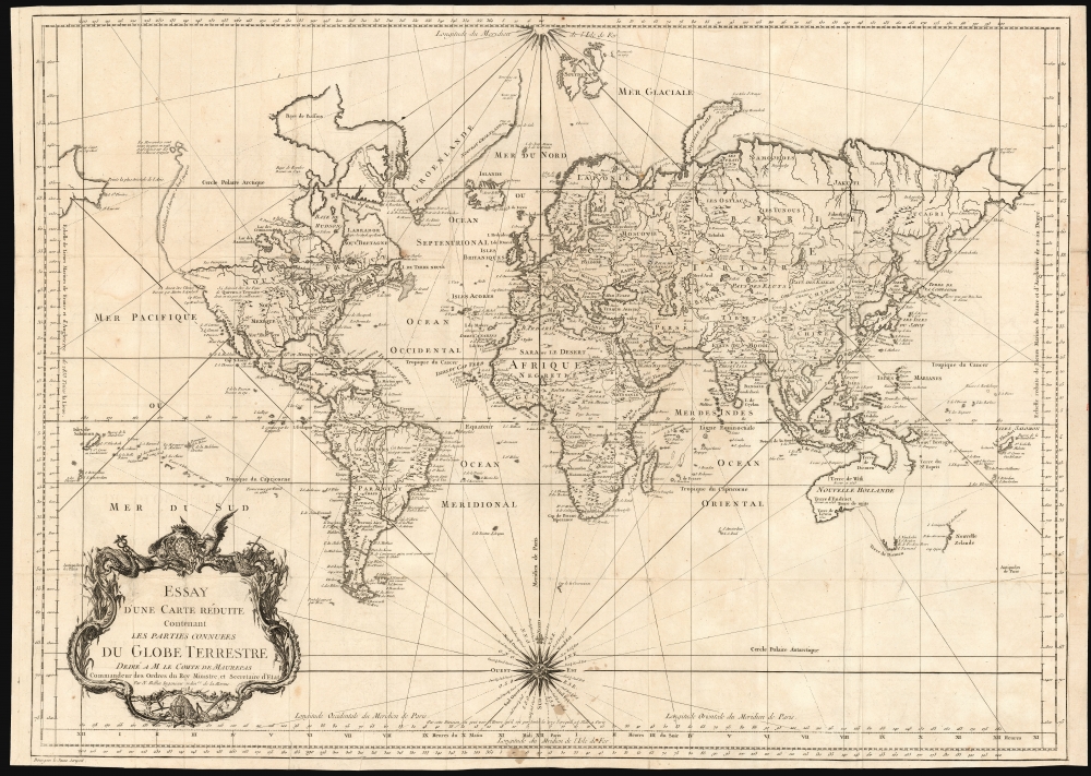
1748 Bellin Map of the World
World-bellin-1748$875.00


Title
Essay d'une Carte Reduite, Contenant Les Parties Connuees du Globe Terrestre Dedié a M le Comte de Maurepas Commandeur des Ordres du Roy Ministre et Secretaire d'Etat.
1748 (dated) 19.75 x 27.5 in (50.165 x 69.85 cm) 1 : 65000000
1748 (dated) 19.75 x 27.5 in (50.165 x 69.85 cm) 1 : 65000000
Description
An attractive first edition, first plate example of J. N. Bellin's 1748 nautical chart of the world. Presents the entire world on a Mercator Projection based on a Paris (L'Isle de Fer) meridian. This is the first iteration of this important map, exhibiting a pre-Cook geography throughout, but most specifically in the Pacific and along the northwest coast of America.
North America to the west of the Mississippi is vaguely rendered according to 16th century expeditions into the region by Coronado, La Salle, De Soto, and others. Bellin identifies the semi-mythical civilizations of Quivira and Teguayo, both associated with legends of the Seven Cities of Gold, in what is modern day Utah, California, and Nevada. Along the western coast the strait discovered by the 17th-century explorer Martin Aguilar is noted. In a grand, optimistic vein, a great the River of the West (Fl. de l'Ouest) is shown extending from the Lake of the Woods (Lac de Bois) nearly to the Pacific. Via additional waterways, this river would have provided an easy link between the Pacific and the Great Lakes, and the Atlantic. The River of the West appeared in many 18th-century maps of the Americas and is reflective of French hopes for a water route from their colonies in Canada and Louisiana to the Pacific. Beyond here becomes extremely vague, with the notation in French 'Probably America extends as far as here.' The Aleutians are vaguely rendered according to various sightings by Vitus Jonassen Bering and Aleksei Chirikov: a note indicates that 'The Muscovites came here in 1743 but were stranded and drowned,' probably a reference to Bering and Chirikov's second Kamchatka expedition.
In the Pacific, various Polynesian Island groups are noted though many are slightly or significantly misplaced. The Solomon Islands are vastly oversized referencing the early 17th claims of Quiros. The other lands discovered and erroneously mapped by Quiros in 1606 and Davis in 1686 during their search of the Great Southern Continent are also noted. Hawaii, as yet undiscovered, is absent. New Zealand and Australia, (here labeled 'Nouvelle Holland,') are depicted mainly as per Abel Tasman's mid-16th century model, albeit the latter has part of its southern coastline ghosted and Van Diemen's Land (Tasmania) is attached to the mainland. New Guinea is connected to northeastern Australia.
Publication History and Census
Bellin's map was engraved by Bourgoin the Younger (either Pierre himself, or his son, there is no record) for inclusion the 1748 first edition of the sixth volume of Prevost's Histoire générale des voyages, and it is so dated. A second plate, with the same date but entirely re-engraved, appears to have been included for later editions of the Histoire; it does not carry Bourgoin's imprint, instead displaying pagination information in the margin. It, too, is dated 1748. A second state of the second plate, probably executed in and around 1780, was amended to include more up-to-date information derived from Cook, Bering and Chirikov. Oddly, despite including dates of discoveries in the body of the map, that second state retained the 1748 date of the original cartouche.CartographerS
Jacques-Nicolas Bellin (1703 - March 21, 1772) was one of the most important cartographers of the 18th century. With a career spanning some 50 years, Bellin is best understood as geographe de cabinet and transitional mapmaker spanning the gap between 18th and early-19th century cartographic styles. His long career as Hydrographer and Ingénieur Hydrographe at the French Dépôt des cartes et plans de la Marine resulted in hundreds of high quality nautical charts of practically everywhere in the world. A true child of the Enlightenment Era, Bellin's work focuses on function and accuracy tending in the process to be less decorative than the earlier 17th and 18th century cartographic work. Unlike many of his contemporaries, Bellin was always careful to cite his references and his scholarly corpus consists of over 1400 articles on geography prepared for Diderot's Encyclopedie. Bellin, despite his extraordinary success, may not have enjoyed his work, which is described as "long, unpleasant, and hard." In addition to numerous maps and charts published during his lifetime, many of Bellin's maps were updated (or not) and published posthumously. He was succeeded as Ingénieur Hydrographe by his student, also a prolific and influential cartographer, Rigobert Bonne. More by this mapmaker...
Pierre Bourgoin (???? - 17??) was a French line and letter engraver active in Paris in the early to mid-18th century. His is best known for engraving map for great French cartographer Jean-Baptiste Bourguignon d 'Anville (1697 - 1782). Learn More...
Condition
Good. Few mended splits at folds; tallow stains at bottom below compass rose. Right margin extended, but border complete. Else very good with a bold, sharp strike.
References
OCLC 763730521.