This item has been sold, but you can get on the Waitlist to be notified if another example becomes available, or purchase a digital scan.
1522 / 1535 Lorenz Fries Map of the World
World-fries-1522$4,750.00

Title
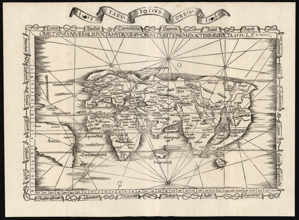
Orbis Typus Universalis Iuxta Hydrographorum Traditionem Exactissime Depicta. 1522 L. F.
1522 (dated) 14 x 18.75 in (35.56 x 47.625 cm)
1522 (dated) 14 x 18.75 in (35.56 x 47.625 cm)
Description
This is a superb example of Lorenz Fries's 1522 map of the world in its 1535 edition: a key discovery-era document, being the second earliest, acquirable, printed map to name 'America' (appearing here in South America).
At Europe's northern extent, Greenland (Gronland) appears north of Scandinavia as per Claudius Clavus' 14th-century mapping of the north parts of the world - with the distinction that it is an island rather than a peninsula connected to Europe. Iceland appears between Greenland and Ireland (Hibernia). England and Scotland are drawn as separate islands - less an indicator of any particular ignorance on the part of Fries, and more on his reliance on Waldseemüller's Carta Marina - which also showed Scotland as a separate island, a detail drawn from the fifteenth-century Portolan charts which informed Waldseemüller's 1516 work.
To the west of the 'tail' and the Sinus Magnus is what appears to be a double-representation of the Indian peninsula. The westernmost of these - India intra Gangem, or India within the Ganges - is the subcontinent. It is strangely distorted, hooking westward around the Persian Gulf, but its situation between the Indus and the Ganges is clear. The peninsula East of the Ganges - India Extra Gangem, or India beyond the Ganges - is inflated and thickened, but its placenames - especially Mallaqua and Loac (Lopburi, Thailand) - clearly identify it as Southeast Asia and the Malay Peninsula. Shirley complained of the inferiority of Fries' delineation of this region compared to Waldseemüller's, but neither mapmaker exhibited notably superior sources. Despite Fries' apparent ignorance of the shaping of Southeast Asia, his placenames reflect an important transitional stage in the discovery-era mapping of South Asia.
Even so, Fries' Southeast Asia is confounded by conflicting ideas and a lack of significant reconnaissance. In the Indian Ocean, the island of Taprobana appears near the subcontinent, close to where one would expect Sri Lanka. Meanwhile, the island Seÿla ('Seylam' on the 1450 map of Fra Mauro, who understood it to be Sri Lanka) appears far to the east at the mouth of the Sinus Magnus. The islands of Bintan Peuta and Java Minor are mapped somewhat correctly. Java Major is far west into the middle of the Indian Ocean, placed near a very east-misplaced Madagascar.
Sources
In this, Fries' map was predated by Waldseemüller's 1507 wall map of the word and its 1520 Apianus reduction, but it received broader distribution than its precursors and thus was influential in establishing 'America' as the accepted terminology for the New World. Fries borrows a title from Waldseemüller's 1513 world map, but he does not directly copy that work, so this map must be considered original work, informed by a variety of sources, including Waldseemüller's 1516 Carta Marina.A Closer Look
As with earlier Ptolemaic maps of the known world, Europe, Asia, and Africa are central. Nonetheless, Fries does not employ Ptolemy's projections with any great precision. Here, more of the New World is included than appears on precursor maps, with South America, Cuba, and Hispaniola recognizable. North America is not present. The northern extreme of the map is marked Mare Congelatum - 'Frozen Sea.' No land masses appear south of the Indian Ocean. The map is visually distinct from other contemporaneous world maps, with its attractive border of intertwined ropes with banners naming the winds, which provided the marine directional terms of the early 16th century. In addition to the nautically-themed rope border, Fries added rhumb lines mimicking the 1513 Waldseemüller. On this type of map, rhumb lines were not intended for navigation but rather to underscore that the seas were navigable.Mapping the North and the West
The map displays a recognizable South America containing the term 'America.' To the north, Cuba is named Isabella and Hispaniola Spagnola.At Europe's northern extent, Greenland (Gronland) appears north of Scandinavia as per Claudius Clavus' 14th-century mapping of the north parts of the world - with the distinction that it is an island rather than a peninsula connected to Europe. Iceland appears between Greenland and Ireland (Hibernia). England and Scotland are drawn as separate islands - less an indicator of any particular ignorance on the part of Fries, and more on his reliance on Waldseemüller's Carta Marina - which also showed Scotland as a separate island, a detail drawn from the fifteenth-century Portolan charts which informed Waldseemüller's 1516 work.
The Dragon's Tail and Southeast Asia
Fries' map shares with its precursors an effort to reconcile Ptolemaic geographical ideas with the medieval reports of Marco Polo and recent Portuguese and Spanish discoveries. In the east, the most eye-catching example of this is the large, curving peninsula embracing a Sinus Magnus ('Great Bay'). This so-called 'Dragon's Tail' is a remnant of Ptolemaic geography, which had that land mass continue south of the Indian Ocean to connect with Africa. Portuguese voyages to India proved that notion incorrect, and from the late 15th century, that connection began to disappear. At the northern extent of the remaining peninsula, the placenames Cathay (Cathaio) and Mangi show that region to be Marco Polo's China. Fries's map, like Waldseemüller's before it, presents this curve of land unambiguously as part of Asia with ocean beyond it - not part of America, as later maps by Oronce Fine and Giacomo Gastaldi would propose.To the west of the 'tail' and the Sinus Magnus is what appears to be a double-representation of the Indian peninsula. The westernmost of these - India intra Gangem, or India within the Ganges - is the subcontinent. It is strangely distorted, hooking westward around the Persian Gulf, but its situation between the Indus and the Ganges is clear. The peninsula East of the Ganges - India Extra Gangem, or India beyond the Ganges - is inflated and thickened, but its placenames - especially Mallaqua and Loac (Lopburi, Thailand) - clearly identify it as Southeast Asia and the Malay Peninsula. Shirley complained of the inferiority of Fries' delineation of this region compared to Waldseemüller's, but neither mapmaker exhibited notably superior sources. Despite Fries' apparent ignorance of the shaping of Southeast Asia, his placenames reflect an important transitional stage in the discovery-era mapping of South Asia.
Even so, Fries' Southeast Asia is confounded by conflicting ideas and a lack of significant reconnaissance. In the Indian Ocean, the island of Taprobana appears near the subcontinent, close to where one would expect Sri Lanka. Meanwhile, the island Seÿla ('Seylam' on the 1450 map of Fra Mauro, who understood it to be Sri Lanka) appears far to the east at the mouth of the Sinus Magnus. The islands of Bintan Peuta and Java Minor are mapped somewhat correctly. Java Major is far west into the middle of the Indian Ocean, placed near a very east-misplaced Madagascar.
Historical Reception
19th century Swedish Arctic explorer and map enthusiast Adolf Erik Nordenskiöld was openly contemptuous of Fries's map - it is difficult to spin the phrase 'bad beyond all criticism' into a positive. Nordenskiöld, nonetheless, did not have the last word on the map. Shirley was more nuanced:'Fries' map is much sought after as it ... reflects the ambiguities of his age. A framework of medieval thinking is having to be re-cast in order to accept the as yet unrealized extent of the newly conquered lands. For decorative value, if not for accuracy, the map has considerable attractions.'Even Nordenskiöld had to admit that this map was a novel work. Between its unique presentation of South Asia and its early naming of America, Fries' map represents an important landmark in the mapping of the world and an Americanum of prime importance to the collector.
Publication History and Census
This map was first issued in the 1522 Lorenz Fries Strasbourg edition of Ptolemy's Geographia. A further edition was produced in that same city in 1525. Afterward, further editions of 1535 and 1541 were published in Lyons and Vienne-in-the-Dauphane, respectively. The editor of the 1535 edition, Michael Villanovus (Servetus), was tried for heresy in 1553 and burned at the stake. Reportedly, Calvin ordered copies of the Servetus edition burned. Consequently, maps from the 1535 edition (of which this is a representative) are scarce. Overall, the four editions of Fries' Ptolemy are well represented in institutional collections. Six separate examples of this edition are listed in OCLC.CartographerS
Lorenz Fries (c. 1490 – 1531) was a German cartographer, cosmographer, astrologer, and physician based in Strasbourg. Little is known of Fries' early life. He may have studied in Padua, Piacenza, Montpellier and Vienna, but strong evidence of this is unfortunately lacking. The first recorded mention of Fries appeared on a 1513 Nuremberg broadside. Fries settled in Strasbourg in March 1519, where he developed a relationship with the St. Die scholars, including Walter Lud, Martin Ringmann and Martin Waldseemüller. There he also befriended the printer and publisher Johann Grüninger. Although his primary profession was as a doctor, from roughly 1520 to 1525 he worked closely with Grüninger as the geographic editor of various maps and atlases based upon the work of Martin Waldseemüller. Although his role is unclear, his first map seems to have been a 1520 reissue of Waldseemüller's world map of 1507. Around this time he also began working on Grüninger's reissue of Waldseemüller's 1513 edition of Ptolemy, Geographie Opus Novissima. That edition included three new maps by Fries based upon the Waldseemüller world map of 1507 – two of these, his maps of East Asia and Southeast Asia are quite significant as the first specific maps of these regions issued by a European publisher. In 1525 Fries decided to leave Strasbourg and surrendered his citizenship, relocating to Trier. In 1528 he moved to Basel. Afterwards he relocated to Metz where he most likely died. In addition to his cartographic work, Fries published tracts on medicine, religion, and astrology. More by this mapmaker...
Martin Waldseemüller (September 11, 1470 - March 16, 1520) was a German cartographer, astronomer, and mathematician credited with creating, along with Matthias Ringmann, the first map to use the placename America. He was born in Wolfenweiler, near Freiburg im Breisgau. Waldseemüller studied at the University of Freiburg and, on April 25, 1507, became a member of the Gymnasium Vosagese at Saint-Dié. Martin Waldseemüller was a major proponent of theoretical or additive cartography. Unlike contemporary Portuguese and Spanish cartographers, who left maps blank where knowledge was lacking, Waldseemüller and his peers speculated based upon geographical theories to fill unknown parts of the map. He is best known for his Universalis Cosmographia a massive 12-part wall map of the world considered the first map to contain the name America, today dubbed as 'America's Birth Certificate'. This map also had significance on other levels, as it combined two previously unassociated geographical styles: Ptolemaic Cartography, based on an ancient Greek model, and the emergent 'carta marina', a type of map commonly used by European mariners in the late 15th and 16th centuries. It also extended the traditional Ptolemaic model westward to include the newly discovered continent of America, which Waldseemüller named after the person he considered most influential in its discovery, Amerigo Vespucci. When Waldseemüller died in 1520, he was a canon of the collegiate Church of Saint-Dié. In contemporary references his name is often Latinized as Martinus Ilacomylus, Ilacomilus, or Hylacomylus. Learn More...
Source
Ptolemy, C., Geographicae Enarrationis..., (Lyons: Servetus) 1535.
Condition
Excellent. Four filled wormholes.
References
OCLC 431574683. Rumsey 11325.089 (1541).