This item has been sold, but you can get on the Waitlist to be notified if another example becomes available, or purchase a digital scan.
1703 Pierre Mortier Nautical Chart or Map of the World (Insular California)
World-mortier-1703$1,250.00

Title
Carte Generale de Toutes Les Costes Du Monde et Les Pays Nouvellement Decouvert, Dresse sur les Relations les Plus Nouvelles Et Principalement sur la Carte que Monsieur N Witsen, a done au Public. / Carte Generale des costes de L'Amerique sur L'Ocean, et les Pays Nouvellement decouvert, Dresse sur les Relations les plus Nouvelles. / Partie Orientale du Monde, qui Contiennent L'Europe, L'Asie, et L'Afrique.
1703 (undated) 23.5 x 36 in (59.69 x 91.44 cm) 1 : 31500000
1703 (undated) 23.5 x 36 in (59.69 x 91.44 cm) 1 : 31500000
Description
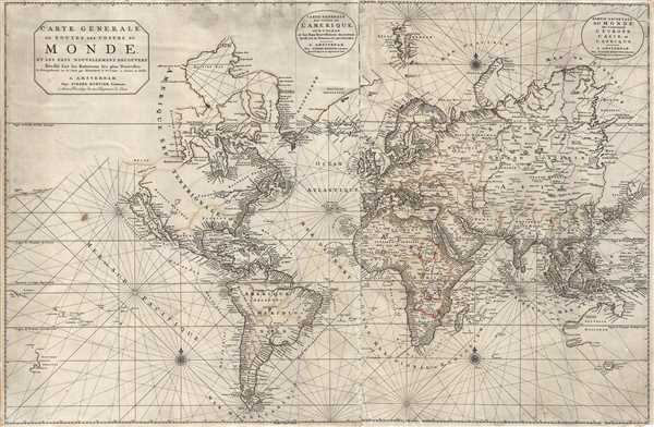
This is Pierre Mortier's 1703 large format nautical chart of the world on a Mercator Projection. Centered on the Atlantic, this impressive chart covers the entire world as it was then known. Rhumb lines appear throughout and the coastlines are heavily labeled while inland is only loosely detailed. The map includes such interesting elements as an insular California, large inland glacial sea in North America, Witsen's curious cartography in northeast Asia, and partial embryonic mappings of Australia, New Zealand, and Tasmania.
This map is cartographically influenced by Hubert Jaillot's 1693 world map. It was expertly re-engraved in Amsterdam in multiple languages and republished in Dutch editions of the Neptune François. Around 1703 the map was updated by Baltasar Ruyter to include the influential c. 1692 cartography of Nicolaes Witsen as regards north and east Asia. This results in a significant expansion of Asia such that it nearly touches upper right cartouche.
We begin our examination of the map with California in its insular form on the Luke Foxe model popularized by Nicholas Sanson in 1657. Luke Foxe was an English navigator who lead a 1631 expedition in search of the Northwest Passage. Although he had no luck in his hunt, his expedition lost no lives, which is a feat for early explores in Arctic waters. The maps associated with his expedition featured a surprising illustration of California in island form. It was Foxe who is credited with introducing the curious form of northern Insular California, including the Bay of Talago, and the unusual peninsula extending from the mainland, Agubela de Gato (both noted in this map), and the Rio de Estiete. The origin of this cartography beyond Foxe remains a mystery given that Foxe himself never sailed anywhere near California.
The idea of an insular California first appeared as a work of fiction in Garci Rodriguez de Montalvo's c. 1510 romance Las Sergas de Esplandian, where he writes
North of California the Strait of Anian give access to a 'Mer Glaciale' and thence to Hudson Bay - hopeful thinking which may owe some debt to the influential French cartographer Guillaume de L'Isle. The Mer Glaciale as seen here cannot help but invoke association with speculations on the 'Mer De L'Ouest,' an idea originally conceived of by Guillaume de L'Isle but popularized by Nicolas De L'Isle, Nicolas De Fer, and others. Although the borders are ghosted, the Glacial Sea connects confidently to Button's Bay, the Hudson, and ultimately the Atlantic. This is an evolution associated with the second state of the America sheet of this map and is novel departure from Pierre Mortier's other mappings of this region.
Further inland the Great Lakes appear in a highly embryonic form despite excellent earlier mapping by such well known cartographers as Coronelli. Here the Lakes appear as a singular inland sea, labeled 'Mer Douce,' itself more akin in form to c. 1565 mappings by De Bry than the cartography of the 18th century.
Asia drawn heavily on the cartographic advances of Dutchman Nicolaes Witsen. This is most evident in the coastline extending from Nova Zembla to Japan. In particular note the curious extension of land leading eastward from Siberia with the note that roughly translates to 'beyond this it is not known.' This oddity appears on numerous maps dating from the late 17th and early 19th century. It is a legacy of Peter the Great's obsession over the search for a Northeast Passage. Around 1648 the Cossack Semen Ivanovich Dezhnyov (1605 - 1673) put together a rough and ready expedition to explore the region. His company consisted of Fedot Alekseyev, traveling with the merchants Andreev and Afstaf'iev (representing the Guselnikov merchant house), who provided their own ship. Gerasim Ankudinov, an experienced sea captain with his own ship and some 30 men. Dezhnev, along with Mikhail Stadukhin recruit some 19 men of his own and procured a traditional Kocha ship. Including escort vessels, a total seven ships sailed from the mouth the Kolyma River, along the Siberian Arctic, to the Anadyr River north of Kamchatka, and in doing so became the first Europeans to sail through the Bering Strait some 80 years before Vitus Bering. Dezhnyov described rounding a large mountainous promontory Chukchi, Tschuktschi, or Chukotka Peninsula. Of the seven vessels the multiple leaders, only three ships, and Dezhnev survived the passage. His expedition was mostly forgotten outside of limited cartographic circles until Gerhardt Friedrich Muller discovered Dezhnyov's reports and in 1758 published them. Dezhnyov ultimately proved that there was indeed a nautical route from Russia to Asia, but at the same time confirmed that it was exceedingly impractical for trade. Nonetheless his promontory was subsequently embraced by European cartographers who, lacking serious scientific data from the Dezhnyov expedition, surmised the form. The first of these was Dutchman Nicolaes Witsen, who prepared a map in 1687 based upon Dezhnyov's records that he discovered on a 1665 trip to Moscow. Many cartographers follows suit, though some, like Mortier here, even went so far as to suggest that this landmass actually connected to America, and in doing so, both embraced and dismissed Dezhnyov, whose journey provided the first definitive proof that Asia was not connected to America.
Typically this map was issued both separately in dual panels, or joined as here, in a single large map - hence the multiple title cartouches. The individual plates exist in multiple states are often mix and matched. Here the left side of the map, the Americas, follows state 2 of the 1693 edition, but the right side, Europe, Africa, and Asia, is fully updated to follow Witsen. A final edition appeared in 1730 bearing the Covens and Mortier imprint. All examples are quite rare.
This map is cartographically influenced by Hubert Jaillot's 1693 world map. It was expertly re-engraved in Amsterdam in multiple languages and republished in Dutch editions of the Neptune François. Around 1703 the map was updated by Baltasar Ruyter to include the influential c. 1692 cartography of Nicolaes Witsen as regards north and east Asia. This results in a significant expansion of Asia such that it nearly touches upper right cartouche.
We begin our examination of the map with California in its insular form on the Luke Foxe model popularized by Nicholas Sanson in 1657. Luke Foxe was an English navigator who lead a 1631 expedition in search of the Northwest Passage. Although he had no luck in his hunt, his expedition lost no lives, which is a feat for early explores in Arctic waters. The maps associated with his expedition featured a surprising illustration of California in island form. It was Foxe who is credited with introducing the curious form of northern Insular California, including the Bay of Talago, and the unusual peninsula extending from the mainland, Agubela de Gato (both noted in this map), and the Rio de Estiete. The origin of this cartography beyond Foxe remains a mystery given that Foxe himself never sailed anywhere near California.
The idea of an insular California first appeared as a work of fiction in Garci Rodriguez de Montalvo's c. 1510 romance Las Sergas de Esplandian, where he writes
Know, that on the right hand of the Indies there is an island called California very close to the side of the Terrestrial Paradise; and it is peopled by black women, without any man among them, for they live in the manner of Amazons.Baja California was subsequently discovered in 1533 by Fortun Ximenez, who had been sent to the area by Hernan Cortez. When Cortez himself traveled to Baja, he must have had Montalvo's novel in mind, for he immediately claimed the 'Island of California' for the Spanish King. By the late 16th and early 17th century ample evidence had been amassed, through explorations of the region by Francisco de Ulloa, Hernando de Alarcon and others, that California was in fact a peninsula. However, by this time other factors were in play. Francis Drake had sailed north and claimed 'New Albion' (identified here on the northwest coast of California Island) near modern day Washington or Vancouver for England. The Spanish thus needed to promote Cortez's claim on the 'Island of California' to preempt English claims on the western coast of North America. The significant influence of the Spanish crown on European cartographers caused a major resurgence of the Insular California theory. Eventually Eusebio Kino, a Jesuit missionary, traveled overland from Mexico to California, proving conclusively the peninsularity of California.
North of California the Strait of Anian give access to a 'Mer Glaciale' and thence to Hudson Bay - hopeful thinking which may owe some debt to the influential French cartographer Guillaume de L'Isle. The Mer Glaciale as seen here cannot help but invoke association with speculations on the 'Mer De L'Ouest,' an idea originally conceived of by Guillaume de L'Isle but popularized by Nicolas De L'Isle, Nicolas De Fer, and others. Although the borders are ghosted, the Glacial Sea connects confidently to Button's Bay, the Hudson, and ultimately the Atlantic. This is an evolution associated with the second state of the America sheet of this map and is novel departure from Pierre Mortier's other mappings of this region.
Further inland the Great Lakes appear in a highly embryonic form despite excellent earlier mapping by such well known cartographers as Coronelli. Here the Lakes appear as a singular inland sea, labeled 'Mer Douce,' itself more akin in form to c. 1565 mappings by De Bry than the cartography of the 18th century.
Asia drawn heavily on the cartographic advances of Dutchman Nicolaes Witsen. This is most evident in the coastline extending from Nova Zembla to Japan. In particular note the curious extension of land leading eastward from Siberia with the note that roughly translates to 'beyond this it is not known.' This oddity appears on numerous maps dating from the late 17th and early 19th century. It is a legacy of Peter the Great's obsession over the search for a Northeast Passage. Around 1648 the Cossack Semen Ivanovich Dezhnyov (1605 - 1673) put together a rough and ready expedition to explore the region. His company consisted of Fedot Alekseyev, traveling with the merchants Andreev and Afstaf'iev (representing the Guselnikov merchant house), who provided their own ship. Gerasim Ankudinov, an experienced sea captain with his own ship and some 30 men. Dezhnev, along with Mikhail Stadukhin recruit some 19 men of his own and procured a traditional Kocha ship. Including escort vessels, a total seven ships sailed from the mouth the Kolyma River, along the Siberian Arctic, to the Anadyr River north of Kamchatka, and in doing so became the first Europeans to sail through the Bering Strait some 80 years before Vitus Bering. Dezhnyov described rounding a large mountainous promontory Chukchi, Tschuktschi, or Chukotka Peninsula. Of the seven vessels the multiple leaders, only three ships, and Dezhnev survived the passage. His expedition was mostly forgotten outside of limited cartographic circles until Gerhardt Friedrich Muller discovered Dezhnyov's reports and in 1758 published them. Dezhnyov ultimately proved that there was indeed a nautical route from Russia to Asia, but at the same time confirmed that it was exceedingly impractical for trade. Nonetheless his promontory was subsequently embraced by European cartographers who, lacking serious scientific data from the Dezhnyov expedition, surmised the form. The first of these was Dutchman Nicolaes Witsen, who prepared a map in 1687 based upon Dezhnyov's records that he discovered on a 1665 trip to Moscow. Many cartographers follows suit, though some, like Mortier here, even went so far as to suggest that this landmass actually connected to America, and in doing so, both embraced and dismissed Dezhnyov, whose journey provided the first definitive proof that Asia was not connected to America.
Typically this map was issued both separately in dual panels, or joined as here, in a single large map - hence the multiple title cartouches. The individual plates exist in multiple states are often mix and matched. Here the left side of the map, the Americas, follows state 2 of the 1693 edition, but the right side, Europe, Africa, and Asia, is fully updated to follow Witsen. A final edition appeared in 1730 bearing the Covens and Mortier imprint. All examples are quite rare.
CartographerS
Pierre Mortier (January 26, 1661 - February 18, 1711) or Pieter Mortier was a cartographer, engraver, and print seller active in Amsterdam during the later 17th and early 18th centuries. Mortier, then known as Pieter, was born in Leiden. He relocated to Paris from 1681 to 1685, adopting the French name Pierre, which he retained throughout his career. While in France, he developed deep French connections by bringing sophisticated Dutch printing technology and experience to nascent French map publishers such as Guillaume De L'Isle (1675 - 1726), Alexis-Hubert Jaillot (c. 1632 - 1712), and Nicholas de Fer (1646 - 1720). Consequently, much of Mortier's business was built upon issuing embellished high quality editions of contemporary French maps - generally with the permissions of their original authors. In the greater context of global cartography, this was a significant advantage as most Dutch map publishes had, at this point, fallen into the miasma of reprinting their own outdated works. By contrast, the cartographers of France were producing the most accurate and up to date charts anywhere. Mortier's cartographic work culminated in the magnificent nautical atlas, Le Neptune Francois. He was awarded the Privilege, an early form of copyright, in 1690. Upon Pierre's death in 1711 this business was inherited by his widow. In 1721, his son Cornelius Mortier took over the day to day operation of the firm. Cornelius partnered with his brother-in-law Jean Covens to form one of history's great cartographic partnerships - Covens and Mortier - which continued to publish maps and atlases until about 1866. More by this mapmaker...
Baltasar Ruyter (fl. c. 1680 - 1710) was a Dutch engraver active in the late 17th and early 18th centuries. His work is most commonly associated with Pierre Mortier, and the firm of his son Jean Covens and Cornielle Mortier (Coven's and Mortier). Little is known of his life. Learn More...
Nicolaes Witsen (May 8, 1641 - August 10, 1717) was a Dutch cartographer, diplomat, writer, businessman, and politician. Witsen was born in Amsterdam to the politically powerful Cornelius Jan Witsen, burgomaster, head bailiff and administrator of the Dutch West India Company. Witsen studied Law at the University of Leiden where he developed an interest in language and maps. He was highly educated and traveled in elite circle, befriending Oliver Cromwell, Andrew Vinius, Cosimo III de'Medici, Melchisédech Thévenot, and others. In 1662 he presented a paper at the Amsterdam Athenaeum Illustre arguing for the effect of comets on earthly life. Witsen joined the VOC (Dutch East India Company) became an expert on shipbuilding, composing several treatises on the subject. His passion, however, remained cartography, particularly the cartography of Asia. Having traveled in embassy to Russia, Witsen contrived to get special access to Russian records on the exploration of Siberia, including the heretofore unknown explorations of Semyon Dezhnev. He also acquired the diary of Maarten Gerritsz Vries, who had explored the coast of Sakhalin in 1643. The Vries diary was thereafter lost. This information he compiled into several influential maps and books on Asia which were extensively copied. One result of this work is the Witsen Peninsula - a narrow outcropping of land extending from Siberia that appears on many maps of the early 17th century. Later, Witsen became Mayor of Amsterdam, a position he held some 13 times, and under whose tenure arts flourished. Witsen died in Amsterdam and was buried near his country home in Egmond aan den Hoef. Learn More...
Source
Mortier, Pierre, Neptune François, (Amsterdam, Pierre Mortier), 1703.
Condition
Good. Two sheets joined - possibly by publisher. Map backed on archival tissue. Some damage and slight loss due to color oxidization - repaired.
References
Shirley, Rodney W., The Mapping of the World: Early Printed World Maps 1472-1700, 559. OCLC 159835222, 309464365.