This item has been sold, but you can get on the Waitlist to be notified if another example becomes available, or purchase a digital scan.
1655 Scolari carte-à-figures Double-Hemisphere World
World-scolari-1655$32,500.00

Title
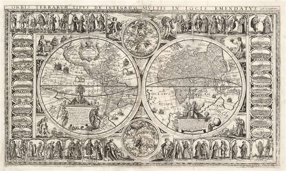
Orbis Terrarum Tipus de Integro Multis in Locis Emendatus.
1655 (dated) 17.25 x 29.5 in (43.815 x 74.93 cm)
1655 (dated) 17.25 x 29.5 in (43.815 x 74.93 cm)
Description
This beautiful, extremely rare, separately-issued, double hemisphere carte á figures world map captures the most desirable elements of 17th century Dutch decorative cartography in one composition - including an Amsterdam imprint and the prominently displayed patronym of 'Willem Blaeu'. Both the imprint and the professed authorship were deliberately misleading: the map was engraved in Venice, not Amsterdam, and it has been attributed to the illustrator and printer Stefano Mozzi Scolari. The map is dated 1655. It is perhaps ironic that of the Dutch mapmakers from whom Scolari sourced this map, not one element appears to have been drawn from Blaeu, apart from his name. The engraver was not fully committed to deception: faintly in the lower right border is an additional, more honest imprint, 'in Venetia à S. Fosca'. Bifolco identifies this location as an engravers' shop associated with Scolari.
The origin of this map in so early a source explains many of the geographical features. California is presented in peninsular form, and the Pacific northwest reaches up to the imaginary kingdoms of Quivira and Anian. A Strait of Anian separates America and Asia. The interior of North America is bisected by an extraordinarily long St. Lawrence River, but the geography of the map pre-dates any European mapping of the Great Lakes. The Antarctic is dominated by a massive continent of Magellanica, an imaginary proto-Antarctica which begins in Tierra del Fuego and covers the entire South Pole, extending north to include a huge New Guinea. Dutch maps, by 1655, had generally dispensed with this southern continent, replacing it instead with Abel Tasman's discoveries of Australia and New Zealand; and since 1625 the most courant mapmakers showed California as an island, and chose not to define any coastline north of Cape Mendocino. The present map also shows Korea as an island, a form derived from Ortelius and Plancius. Most mapmakers after Hondius and Jansson illustrated Korea correctly as a peninsula.
The map's treatment of Spitzbergen and its vicinity diverges from examples of the Geelkercken, with the Svalbard coast continuing further south and showing more coastline of the neighboring island to the east. It is unclear whether this is a product of having a different model to work from, or a necessary alteration to the coastline to make legible the place names applied to the northern coast of Norway.
The decorative cartouches themeslves are also copied from the Geelkercken original: to the right, a figure with the spear and torch, surrounded by weapons - possibly Minerva, wisdom-in-war. To the left, a garlanded plinth flanked by a native warrior and a conquistador, who appear to be sneaking up on each other.
The two celestial charts, displaying the skies of the northern and southern hemispheres, are flanked with allegorical figures representing the elements: Earth with her cornucopia; Water with an eternally flowing jug (and a baptism in the background), Air surrounded with windheads, birds and clouds; and Fire, shown in his element with dragons sporting around him and a sacrificial altar in the background. In contrast with the other decorative engraving of this map, the celestial charts and these four figures are shown in mirror-image from their source, which we suspect results from the image being traced in reverse from the original in order to more accurately reproduce the constellation charts. Note that the lettering in all these areas is not presented in reverse, and like the rest of the map it seems to have been engraved freehand. This is particularly evident in the text appearing in the cruxes of the hemispheres: despite being copied word-for-word from the Visscher, it is not spaced as evenly as one would expect from a traced, or more meticulously planned copy.
Shirley identified a very similar map (Shirley 333) which shares all of the compositional elements of the present map (including the spurious Blaeu imprint, and the error in duplicating the title 'Poloni' for two separate sets of figures) but whose execution differs significantly enough to lead us to believe it to be an entirely separate plate engraved on the same general plan - possibly by the same author, or at least the same shop. The map in Shirley does not have the Venice imprint visible on ours. The date of 1630 appearing on the Shirley map is impossible for the reasons applied above in dating our map: it may have been applied for the same reason Blaeu's patronym was included on the map. Shirley mentions a copy of the map dated 1669 at the Newberry, and it may be the date was changed frequently in order to present the impression of the map being more up-to-date than it actually was.
More of Everything You Want
By the mid-17th century, the double-hemisphere format was the most fashionable presentation of a world map, offering abundant space between and about the hemispheres for ornament. Also, the convention of the carte á figures - a map, bordered with plans and views of cities, with figures displaying the styles of men and women living in the depicted region - was well established and widely desirable. Thus, the inclusion of not only these elements, but also more of them than other available map, appears to have been well-calculated to appeal to popular interests. The map includes allegorical depictions of the four elements AND the four seasons, when most comparable maps only attempted one of these motifs. There are twenty pairs of figures, and eighteen city views. The decorative engraving of the two hemispheres features two elaborate allegorical cartouches, seven sailing ships, two native canoes, a mermaid spouting wetly from a horn, and a sea monster.Tracing the Source Maps
Since the Venetian engraver borrowed from a variety of sources, it is appropriate to attempt to trace them.The terrestrial Hemispheres: Geelkercken's 1632 World
The map proper is copied from Nicolaes van Geelkercken's Orbis Terrarum Descriptio Duobis Planis Hemisphaeriis Comprehēsa, first engraved by Joannes Jansson in 1617, with Scolari borrowing specifically from the 1632 state of that map (whose distinctive treatment of Tierra del Fuego as an archipelago is preserved). The general form of, and the text from the two decorative cartouches are also preserved, including Geelkercken's 'AMSTELODAMI' from the right-hand cartouche.The origin of this map in so early a source explains many of the geographical features. California is presented in peninsular form, and the Pacific northwest reaches up to the imaginary kingdoms of Quivira and Anian. A Strait of Anian separates America and Asia. The interior of North America is bisected by an extraordinarily long St. Lawrence River, but the geography of the map pre-dates any European mapping of the Great Lakes. The Antarctic is dominated by a massive continent of Magellanica, an imaginary proto-Antarctica which begins in Tierra del Fuego and covers the entire South Pole, extending north to include a huge New Guinea. Dutch maps, by 1655, had generally dispensed with this southern continent, replacing it instead with Abel Tasman's discoveries of Australia and New Zealand; and since 1625 the most courant mapmakers showed California as an island, and chose not to define any coastline north of Cape Mendocino. The present map also shows Korea as an island, a form derived from Ortelius and Plancius. Most mapmakers after Hondius and Jansson illustrated Korea correctly as a peninsula.
The map's treatment of Spitzbergen and its vicinity diverges from examples of the Geelkercken, with the Svalbard coast continuing further south and showing more coastline of the neighboring island to the east. It is unclear whether this is a product of having a different model to work from, or a necessary alteration to the coastline to make legible the place names applied to the northern coast of Norway.
The decorative cartouches themeslves are also copied from the Geelkercken original: to the right, a figure with the spear and torch, surrounded by weapons - possibly Minerva, wisdom-in-war. To the left, a garlanded plinth flanked by a native warrior and a conquistador, who appear to be sneaking up on each other.
The Celestial Hemispheres and Allegorical Figures: Visscher's 1638/ 1652 World
It is perhaps surprising that the geographical information above was drawn from the Geelkercken, because the next layer of decorative detail came from a map which, overall, reflected a more modern geographical point of reference. In terms of the decorative elements themselves, however, the 1638 Claesz Janzoon Visscher Orbis Terrarum Typus de Integro Multis in Locis Emendatus represented a very apt source - being one of the few maps to combine the allegorical and astronomical elements. At the four corners of the Scolari are presented four figures representing the seasons: these are clearly modeled on the Visscher: a zaftig Spring, with a basket of fruit and gardens in the background; a vigorous and muscular Summer harvesting grain; a Dionsysian Autumn brandishing grapes; and an elderly, bundled-up Winter with a fire-pot with a sledding scene in the background.The two celestial charts, displaying the skies of the northern and southern hemispheres, are flanked with allegorical figures representing the elements: Earth with her cornucopia; Water with an eternally flowing jug (and a baptism in the background), Air surrounded with windheads, birds and clouds; and Fire, shown in his element with dragons sporting around him and a sacrificial altar in the background. In contrast with the other decorative engraving of this map, the celestial charts and these four figures are shown in mirror-image from their source, which we suspect results from the image being traced in reverse from the original in order to more accurately reproduce the constellation charts. Note that the lettering in all these areas is not presented in reverse, and like the rest of the map it seems to have been engraved freehand. This is particularly evident in the text appearing in the cruxes of the hemispheres: despite being copied word-for-word from the Visscher, it is not spaced as evenly as one would expect from a traced, or more meticulously planned copy.
The City Views
The map is bordered on the left and right with eighteen city views - this is a wealth of such images on any carte á figures, but for a world map such views are virtually never seen except on the finest, largest wall maps. Blaeu's carte á figures world map, for example, had no city views properly speaking - showing instead the Seven Wonders of the World. The cartes á figures of most Dutch mapmakers generally had city views on more regional maps, highlighting the chief cities of those specific areas. It is probably fruitless for us to try to trace the specific sources for the views depicted here, but the panoramic format of most of them seems to best correspond with the regional maps of Jansson. Four of these - Havana, Cusco, Pernambuco and Mexico - are from the Americas.The Figures
Thus far, we have identified a source for only one of the twenty (twenty!) pairs of figures that border the top and bottom of this map. The pair identified as English is based on the corresponding pair on the 1638 Visscher. None of the remaining nineteen resemble the figures in any carte á figures we have studied. It may well be that these, among all the elements of this map, are original work. Certainly, Scolari was first and foremost an illustrator, so these unique and vivacious images would fall within his talents.The Engraving of the Map
Close scrutiny of the map's engraving leads us to suppose that while copies of the originals were certainly at hand, the engraver reproduced most of the images without benefit of tracing or any sort of direct copying (with the exception of the celestials and the neighboring engravings noted above.) While the features traceable to either the Geelkercken or the Visscher are copied one-to-one, differences in the actual engraving of those elements suggest the work was done freehand, perhaps to save the time of making additional fair copies to work from. (The lettering, in particular, suggests that the copying was executed in haste.)Shirley identified a very similar map (Shirley 333) which shares all of the compositional elements of the present map (including the spurious Blaeu imprint, and the error in duplicating the title 'Poloni' for two separate sets of figures) but whose execution differs significantly enough to lead us to believe it to be an entirely separate plate engraved on the same general plan - possibly by the same author, or at least the same shop. The map in Shirley does not have the Venice imprint visible on ours. The date of 1630 appearing on the Shirley map is impossible for the reasons applied above in dating our map: it may have been applied for the same reason Blaeu's patronym was included on the map. Shirley mentions a copy of the map dated 1669 at the Newberry, and it may be the date was changed frequently in order to present the impression of the map being more up-to-date than it actually was.
Publication History and Census
This map is extremely rare, and may be a sole surviving example. The Newberry copy (Shirley 333) is a different plate entirely; there is a 1669 map of the same title at the Buffalo and Erie County Public Library but it is insufficiently precisely described for us to determine whether it corresponds to our example or the Newberry's. We see no other possible examples in OCLC, and are not aware of any other example of this map to have come on the market.CartographerS
Stefano Mozzi Scolari (c. 1612 - 1691) was a Venetian engraver and printer active between 1644 and 1687. He was known primarily as an illustrator and would be among the first engravers to devote his activity entirely to illustrated editions. His work included pieces entirely drawn and engraved by himself, images produced in collaboration with other artists and editors, and the reproduction of already published copperplates. This latter area appears to have been the reproduction of maps by other authors - for example his 1657 edition of Greuter's 1630 map of Italy - including the production of maps incorporating elements of various authors in a single work. He is most associated with his work from the vicinity of the Venetian parish church of San Zulian, where he also probably had lived since 1642, but Stefano Bifolco has asserted that he was also connected to the printers' shop at Santa Fosca. He was a member of the Venetian painters' guild between 1660 and 1683; his wills reflect his status as a well-off craftsman and owner of a printer shop. More by this mapmaker...
Nicolaes van Geelkercken (ca. 1585 - 1656) was a Dutch surveyor, cartographer and publisher active in the early 17th century. He is thought to have begun his work as a cartographer, engraver, and colorist in the shop of Jodocus Hondius. Starting in 1610, he began producing maps to illustrate current conflicts of interest. In order to ensure that his news maps were up to date and accurate, Geelkercken was known to accompany the Dutch army on campaign. He was succeeded in his trade by his sons Isaac van Geelkercken, Jacob van Geelkercken and Arnold van Geelkercken. Learn More...
Jan Jansson or Johannes Janssonius (1588 - 1664) was born in Arnhem, Holland. He was the son of a printer and bookseller and in 1612 married into the cartographically prominent Hondius family. Following his marriage he moved to Amsterdam where he worked as a book publisher. It was not until 1616 that Jansson produced his first maps, most of which were heavily influenced by Blaeu. In the mid 1630s Jansson partnered with his brother-in-law, Henricus Hondius, to produce his important work, the eleven volume Atlas Major. About this time, Jansson's name also begins to appear on Hondius reissues of notable Mercator/Hondius atlases. Jansson's last major work was his issue of the 1646 full edition of Jansson's English Country Maps. Following Jansson's death in 1664 the company was taken over by Jansson's brother-in-law Johannes Waesberger. Waesberger adopted the name of Jansonius and published a new Atlas Contractus in two volumes with Jansson's other son-in-law Elizée Weyerstraet with the imprint 'Joannis Janssonii haeredes' in 1666. These maps also refer to the firm of Janssonius-Waesbergius. The name of Moses Pitt, an English map publisher, was added to the Janssonius-Waesbergius imprint for maps printed in England for use in Pitt's English Atlas. Learn More...
Claes Jansz Visscher (1587 - 1652) established the Visscher family publishing firm, which were prominent Dutch map publishers for nearly a century. The Visscher cartographic story beings with Claes Jansz Visscher who established the firm in Amsterdam near the offices of Pieter van den Keer and Jadocus Hondius. Many hypothesize that Visscher may have been one of Hondius's pupils and, under examination, this seems logical. The first Visscher maps appear around 1620 and include numerous individual maps as well as an atlas compiled of maps by various cartographers including Visscher himself. Upon the death of Claes, the firm fell into the hands of his son Nicholas Visscher I (1618 - 1679), who in 1677 received a privilege to publish from the States of Holland and West Friesland. The firm would in turn be passed on to his son, Nicholas Visscher II (1649 - 1702). Visscher II applied for his own privilege, receiving it in 1682. Most of the maps bearing the Visscher imprint were produced by these two men. Many Visscher maps also bear the imprint Piscator (a Latinized version of Visscher) and often feature the image of an elderly fisherman - an allusion to the family name. Upon the death of Nicholas Visscher II, the business was carried on by the widowed Elizabeth Verseyl Visscher (16?? - 1726). After her death, the firm and all of its plates was liquidated to Peter Schenk. Learn More...
Condition
Excellent, near fine. Printed to two sheets and joined, with deckled edges left and right. Full margins and no repairs.
References
cf.OCLC 50784513. Compare with Shirley, Rodney W., The Mapping of the World: Early Printed World Maps 1472-1700, #295, #333 and #346. cf. Klaus Stopp, ‘Drei Karten von Francesco Sabatini', Mappae Antiquae Liber Amicorum.