This item has been sold, but you can get on the Waitlist to be notified if another example becomes available, or purchase a digital scan.
1831 Teesdale Map of The World
World-teesdale-1831$200.00

Title
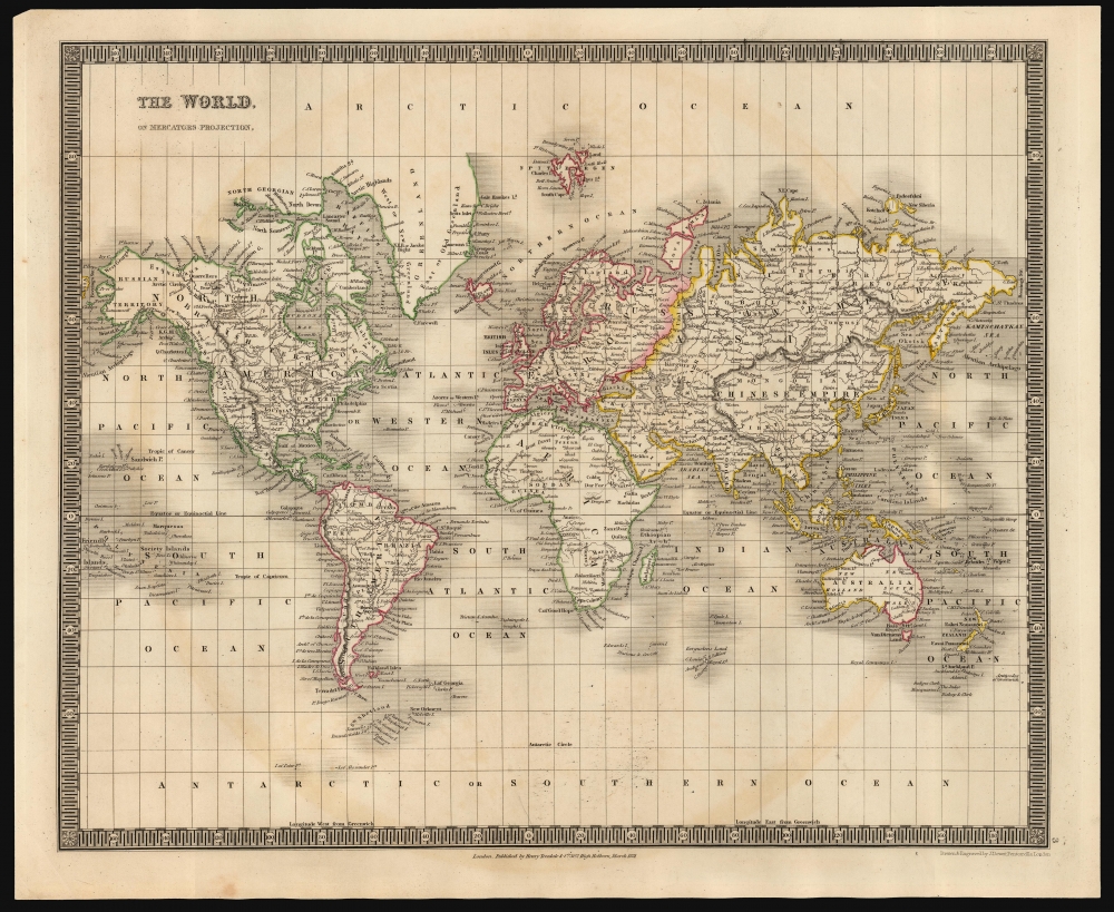
The World, On Mercators Projection.
1831 (dated) 13 x 16 in (33.02 x 40.64 cm) 1 : 100000000
1831 (dated) 13 x 16 in (33.02 x 40.64 cm) 1 : 100000000
Description
This is an 1831 Henry Teesdale and John Crane Dower map of the world. It covers the explored world on a Mercator projection: the Americas, Europe, Asia, Africa, Australia and Oceania are presented clearly. The Arctic and Antarctic regions, as yet unpenetrated by explorers, are bare of detail.
The Mercator projection proved to be well suited to a map showing the detail that this one can: the major flaw of that projection is that it dramatically distorts the size of regions as they near the poles, and Teesdale's map has little to show beyond eighty degrees in either direction. The detail to the north stops at Spitzbergen around 80 degrees; the northernmost extents of Greenland and the Canadian Arctic are shown incomplete, although the map offers tantalizing hope of a northwest passage along Barrows' Strait.
The Southern polar region is devoid of detail beyond the Antarctic Circle, with the exception of Peter I Island and Alexander Island, discovered respectively in October and January 28, 1821, by the Russian expedition under Fabian Gottlieb von Bellingshausen.
A Closer Look
The map neatly labels regions, cities, and major rivers. Greater mountain ranges are indicated by hachure. National borders are not shown, although neatly applied hand color distinguishes continents (for example, the transition between Europe and Asia). Also, in Australia the coastline is colored both in yellow and red, drawing a distinction between the western 'New Holland' and the eastern 'New South Wales.'The Mercator projection proved to be well suited to a map showing the detail that this one can: the major flaw of that projection is that it dramatically distorts the size of regions as they near the poles, and Teesdale's map has little to show beyond eighty degrees in either direction. The detail to the north stops at Spitzbergen around 80 degrees; the northernmost extents of Greenland and the Canadian Arctic are shown incomplete, although the map offers tantalizing hope of a northwest passage along Barrows' Strait.
The Southern polar region is devoid of detail beyond the Antarctic Circle, with the exception of Peter I Island and Alexander Island, discovered respectively in October and January 28, 1821, by the Russian expedition under Fabian Gottlieb von Bellingshausen.
Publication History and Census
This map was drawn and engraved by John Crane Dower and published by Henry Teesdale in 1831 in his A New General Atlas of the World. While not demonstrably rare, it is neglected by institutional collections: only three separate examples of the map are listed in OCLC, and only one of these is this 1831 edition.CartographerS
Henry Teesdale (December 1776 - January 1856) was a British map publisher active in the first half of the 19th century. Teesdale was born in London. He was elected to the Royal Geographical Society in 1830. Teesdale initially partnered with John Hordan and William Colling Hobson as Henry Teesdale and Company, but this partnership was dissolved in 1832. Afterwards Teesdale continued to publish maps and atlases on his own account. He worked with several major British map engravers of the period including John Crane Dower, Christopher Greenwood, and Josiah Henshall, among others. His most prominent work is a large map of the world engraved by Dower. He must have enjoyed considerable commercial success because in 1845 he is registered as a partner in the Royal Bank of Scotland. Teesdale died in January of 1856 and was buried in All Souls, Kensal Green. More by this mapmaker...
John Crane Dower (1791 - February 20, 1847) was an English engraver, map publisher, and printer active in northern London during the first half of the 19th century. Dower had his office at 6 Cumming Place, Pentonville, London. He was most active as an engraver from 1820 to 1847, where he produced work for John Greenwood, William Fowler, Henry Teesdale, Thomas Moule, Geroge Bradshaw, and others. Dower passed his business on two his two sons, John James Downer, and Fredreric Jamesd Dower. Learn More...
Source
Teesdale, H., A New General Atlas of the World..., (London: Teesdale) 1831.
Condition
Very good. Few areas of light soiling. Else excellent with original outline color.
References
OCLC 310936609.