Title
Tabu. Nova Orbis.
1522 (undated)
12.25 x 17 in (31.115 x 43.18 cm)
Description
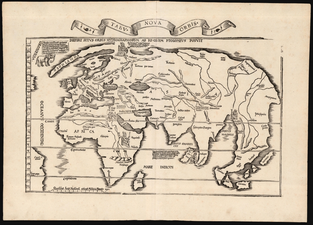
A superb example of Lorenz Fries's 1522 map of the world. This is one of the great Discovery-Era world maps, capturing the impact of contemporary exploration on the late-Roman cartographic models of Ptolemy.
America
Although the map's focus is the Old World of Europe, Asia, and Afirca, parts of America can be seen. The visible part of South America is identified as Terra Papagalli (Land of Birds). In the Northern Hemisphere, there is a tantalizing unexplained coastline abutting the left border. Based on Martin Waldseemüller's 1516 Carta Marina, we can infer this to be Gaspar and Miguel Corte-Real's poorly documented discovery of Newfoundland or Nova Scotia, here extended eastward some 600 miles.The North Parts of the World
At Europe's northern extent, Greenland (Gronland) is rendered as a long peninsula extending north of Scandinavia, following the 15th-century cartography of Claudius Clavus. An illustration, apparently of an elephant, is revealed by the text attending it to be a depiction of the morse: a walrus. 'The walrus is a huge animal, the size of an elephant, and it has two long teeth which are quadrangular, and lacks joints in its legs. It is found in the northern promontories of Norway, and they travel together in groups of two hundred animals.'Muscovy
Another element drawn from the 1516 Carta Marina is the map's depiction of the Grand Prince of Muscovy. The text is derived largely also from the 1516 map, and reads: 'Here rules the Grand Prince and Emperor of Russia and Muscovy, King of Podolia and Plescau.' The Muscovite conquest of Plescau (Pskov) had only occurred in 1510, so Waldseemüller's source in 1516 was very current.
The sources available to Waldseemüller and Fries are not known; but the use of the term 'Emperor' suggests a Muscovite source, rather than Lithuanian or Polish: the title was not even universally accepted in Muscovy during the reign of Vassily III, which was contemporaneous to both the 1516 and 1522 maps. The iconography used on the 1516 Waldseemüller and the 1522 Fries also differs: the image of the ruler on the 1516 is incontrovertibly Christian (carrying a cross, wearing a crown resembling a Bishop's mitre). The figure seated in the 1522 map is wearing a turban, and carries a scepter which only vestigally, at best, incorporates a cross; perhaps the simplification is simply due to space constraints, but the image presented on the Fries more resembles an Asian potentate than a European one.
Another interesting detail to this aspect of the map is that despite the text's reference to the 'Grand Prince and Emperor of Russia and Muscovy', Moscovia and Russia are quite distinct from one another on the map - Muscovy appearing well to the north and East, but Russia appearing close to the Black Sea in the region historically known as Kievan Rus, and more consistent with today's Ukraine. The 1513 Waldseemüller, which provided the topology for this map, names Russia but does not name Muscovy at all.The Dragon's Tail and Southeast Asia
Fries' map illustrates an ongoing effort to reconcile Ptolemaic geography with Marco Polo, and more recent Portuguese and Spanish discoveries. In the east, the most eye-catching example of this is the large, curving peninsula embracing a Sinus Magnus ('Great Bay'). This so-called 'Dragon's Tail' is a remnant of Ptolemaic geography, in which a land mass continues south of the Indian Ocean to connect with Africa. Vasco de Gamma's successful 1498 voyage to India disproved the idea of an enclosed Indian Ocean, but part of that theory, the Dragon's Tail, persisted well into the 16th century. At the northern extent of the remaining peninsula, the placenames Cathay (Cuthaia) and Mangi show that region to be Marco Polo's China. Fries's map presents this curve of land unambiguously as part of Asia with ocean beyond it - not part of America, as proposed in later maps by Oronce Fine and Giacomo Gastaldi.
To the west of the 'Tail' and the Sinus Magnus is Waldseemüller's modern depiction of India and the Malay Peninsula, termed India intra Gangem, and India Extra Gangem, respectively. Taprobana, an ancient placename frequently associated with Sri Lanka, is here applied to an island much more reminiscent of Sumatra. Meanwhile, scattered south and east of the 'Dragon's Tail' are islands in an early approximation of the East Indies: Seylam and Java Minor appear with Peuta and Java Major.Publication History and Census
This map was first issued in the 1522 Lorenz Fries Strasbourg edition of Ptolemy's Geographia. A further edition was produced in that same city in 1525. Afterward, further editions of 1535 and 1541 were published in Lyons and Vienne-in-the-Dauphane, respectively. The editor of the 1535 edition, Michael Villanovus (Servetus), was tried for heresy in 1553 and burned at the stake. Reportedly, Calvin ordered copies of the Servetus edition burned. Consequently, maps from the 1535 edition (of which this is a representative) are scarce. Overall, the four editions of Fries' Ptolemy are well represented in institutional collections. Six separate examples of this edition are listed in OCLC.
CartographerS
Lorenz Fries (c. 1490 – 1531) was a German cartographer, cosmographer, astrologer, and physician based in Strasbourg. Little is known of Fries' early life. He may have studied in Padua, Piacenza, Montpellier and Vienna, but strong evidence of this is unfortunately lacking. The first recorded mention of Fries appeared on a 1513 Nuremberg broadside. Fries settled in Strasbourg in March 1519, where he developed a relationship with the St. Die scholars, including Walter Lud, Martin Ringmann and Martin Waldseemüller. There he also befriended the printer and publisher Johann Grüninger. Although his primary profession was as a doctor, from roughly 1520 to 1525 he worked closely with Grüninger as the geographic editor of various maps and atlases based upon the work of Martin Waldseemüller. Although his role is unclear, his first map seems to have been a 1520 reissue of Waldseemüller's world map of 1507. Around this time he also began working on Grüninger's reissue of Waldseemüller's 1513 edition of Ptolemy, Geographie Opus Novissima. That edition included three new maps by Fries based upon the Waldseemüller world map of 1507 – two of these, his maps of East Asia and Southeast Asia are quite significant as the first specific maps of these regions issued by a European publisher. In 1525 Fries decided to leave Strasbourg and surrendered his citizenship, relocating to Trier. In 1528 he moved to Basel. Afterwards he relocated to Metz where he most likely died. In addition to his cartographic work, Fries published tracts on medicine, religion, and astrology. More by this mapmaker...
Martin Waldseemüller (September 11, 1470 - March 16, 1520) was a German cartographer, astronomer, and mathematician credited with creating, along with Matthias Ringmann, the first map to use the placename America. He was born in Wolfenweiler, near Freiburg im Breisgau. Waldseemüller studied at the University of Freiburg and, on April 25, 1507, became a member of the Gymnasium Vosagese at Saint-Dié. Martin Waldseemüller was a major proponent of theoretical or additive cartography. Unlike contemporary Portuguese and Spanish cartographers, who left maps blank where knowledge was lacking, Waldseemüller and his peers speculated based upon geographical theories to fill unknown parts of the map. He is best known for his Universalis Cosmographia a massive 12-part wall map of the world considered the first map to contain the name America, today dubbed as 'America's Birth Certificate'. This map also had significance on other levels, as it combined two previously unassociated geographical styles: Ptolemaic Cartography, based on an ancient Greek model, and the emergent 'carta marina', a type of map commonly used by European mariners in the late 15th and 16th centuries. It also extended the traditional Ptolemaic model westward to include the newly discovered continent of America, which Waldseemüller named after the person he considered most influential in its discovery, Amerigo Vespucci. When Waldseemüller died in 1520, he was a canon of the collegiate Church of Saint-Dié. In contemporary references his name is often Latinized as Martinus Ilacomylus, Ilacomilus, or Hylacomylus. Learn More...
Source
Ptolemy, C., Geographicae Enarrationis..., (Lyons: Servetus) 1535.
Condition
Excellent. Few tiny wormholes, else fine.
References
OCLC 908578883. Rumsey 10891.133 (1525). Shirley, Rodney W., The Mapping of the World: Early Printed World Maps 1472-1700, #49.