1796 John Barrow Map of Zhoushan Coast (south of Shanghai), China
ZhousanChina-barrow-1796$400.00
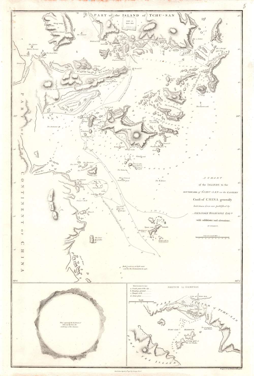

Title
A Chart of the Islands to the Southward of Tchu-san on the Eastern Coast of China generally laid down from one published by Alexander Dalrymple Esqre. with additions and alternations.
1796 (undated) 15 x 22.25 in (38.1 x 56.515 cm) 1 : 350000
1796 (undated) 15 x 22.25 in (38.1 x 56.515 cm) 1 : 350000
Description
This is a rare 1796 John Barrow map of modern day Zhoushan (舟山市; Tchu-San), China, prepared to illustrate the official report of the Macartney Embassy to China. At the time Zhoushan (Ting Hai) was a walled city just south of modern-day Shanghai on the opposite side of Hangzhou Bay. The city guarded the entrance to the Qiantang River and thus access to Hangzhou (杭州市). Coverage here extends from Zhoushan Islands south to roughly Dayang Islet and Jiushan Chan Island. Tracks follow the Clarence, one of Macartney's ships as it entered and left the Bay. At the bottom of the map, a curious circular panorama illustrates the view from the Clarence from its anchorage in Zhoushan harbor.
The Failed Embassy
The 1793 Macartney Mission (马加尔尼使团) was the first British diplomatic mission to China and marks the first of a series of cultural misunderstanding between China and Britain. George Macartney (1737 - 1806) was tasked with convincing the Chinese Emperor Qianlong to ease restrictions on trade between Great Britain and China and to allow the British a permanent embassy. Macartney was successful in none of these things - a fact often laid on his refusal to 'kowtow' before the emperor, a ceremonial tradition that was central to all court procedure. While Dutch and Portuguese merchants happily performed the ritual - thus receiving the desired trade concessions, Macartney, believing King George III to be the greater power, refused. While much has been made of Macartney's refusal to kowtow to the emperor, the failure of the mission might equally be laid on the Qianlong Emperor's haughty approach. In a subsequent letter to King George III, the emperor patronizingly referred to all Europeans as 'barbarians', all nations of the earth as being subordinate to China, and addressed the king himself as a Chinese subject, abjuring him to 'Tremblingly obey and show no negligence!'Publication History and Census
The map was printed in 1796 to accompany Sir George Leonard Staunton's (1737 - 1801) 1797 An authentic account of an embassy from the King of Great Britain to the emperor of China. It was drawn by John Barrow based upon the cartographic work of Alexander Dalrymple. It was engraved by B. Baker and published by George Nicol. The Account appears four institutional collections listed in OCLC. The separate map is cataloged in multiple institutional collections.CartographerS
John Barrow (June 19, 1764 – November 23, 1848) was an English statesman, cartographer, and writer active in the late 18th and early 19th centuries. Barrow was born in the village of Dragley Beck, in Ulverston, Cumbria. His first recorded work was as a superintending clerk at a Liverpool iron foundry, but by his early 20s, transitioned to teaching mathematics at a private school in Greenwich. One of his pupils, the young son of Sir George Leonard Staunton, favored him and he was introduced to Lord George Macarteny. Barrow accompanied Macartney as a comptroller of household, on his 1792-1794, embassy to China. Having acquitted himself well, Barrow was hired by Macartney as private secretary on a political mission to the newly acquired Cape Colony, South Africa. Barrow was given the difficult task of reconciling Boer settlers with the indigenous African population. In the course of this voyage he traveled throughout the Cape Colony, coming to know that country well. There he married botanical artist Anna Maria Truter, and, in 1800, acquired a home with the intention of settling in Cape Town. Following the 1802 Peace of Amiens, the British surrendered the colony and Barrow returned to England where he was appointed Second Secretary to the Admiralty, a post he held with honor for the subsequent 40 years. In his position at the Admiralty Barrow promoted various voyages of discovery, including those of John Ross, William Edward Parry, James Clark Ross, and John Franklin. The Barrow Strait in the Canadian Arctic as well as Point Barrow and the city of Barrow in Alaska are named after him. He is reputed to have been the initial proposer of St Helena as the new place of exile for Napoleon Bonaparte following the Battle of Waterloo in 1815. He was a member of the Royal Society and the Raleigh Club, a forerunner of the Royal Geographical Society. In 1835 Sir Robert Peel conferred upon him a baronetcy. More by this mapmaker...
Alexander Dalrymple (July 24, 1737 - June 19, 1808) was a Scottish geographer and hydrographer active with East India Company and later as first Hydrographer to the British Admiralty. Dalrymple was born at Newhailes, near Edinburgh, Scotland, the 11th of 15 children of James Dalrymple and his wife, Christian Hamilton, the daughter of the Earl of Haddington. He joined the East India Company in 1752, at which point he was immediate sent to Madras, India. There he advocated for increased trade with the East Indies and China, negotiating a treaty with the Sultan of Sulu and visiting Canton (Guangzhou), China. He went on to develop an interest in historical voyages and navigation. In 1772, Dalrymple published his first set of charts, four of which were of the seas around Sulu. In 1779, he headed the hydrographic office of the East India Company, and that of the Admiralty in 1795. Dalrymple was instrumental in advancing the mapping of uncharted waters, particularly in the East Indies and the Pacific Ocean. He was an advocate for the existence of a large southern continent, Terra Australis, which influenced British exploration efforts. Dalrymple’s extensive work on nautical charts and navigational information significantly improved the safety and accuracy of sea voyages. His dedication to hydrography laid the groundwork for future maritime exploration. Learn More...
Benjamin Baker (1766 - June 29, 1841) was British engraver active in the late 18th and early 19th centuries. Baker was born in London, the son of instrument maker Edward Baker (1730 - 1797). As a young map he was apprenticed to Thomas Beresford, a watchmaker. This likely did not work out, as he was turned over to the engraver, mapmaker, and globemaker William Palmer (1739 - 1812). Baker rose to prominence as an engraver for the British Admiralty and British Ordnance Survey. In time he became the principal engraver for the Ordnance Survey, not only engraving himself, but overseeing the entire team of Ordnance engravers. His son, Benjamin Richard Baker (1792 - 1876) was also a mapmaker, engraver, draughtsman, lithographer, and printer. Learn More...
Condition
Very good.
References
OCLC 225063613. Royal Maritime Museum, G272:2/10.