1944 First U.S. Army Situation Map of Aachen, Germany, Illustrating German Defenses
AachenDefenses-firstarmy-1944$3,500.00

Title
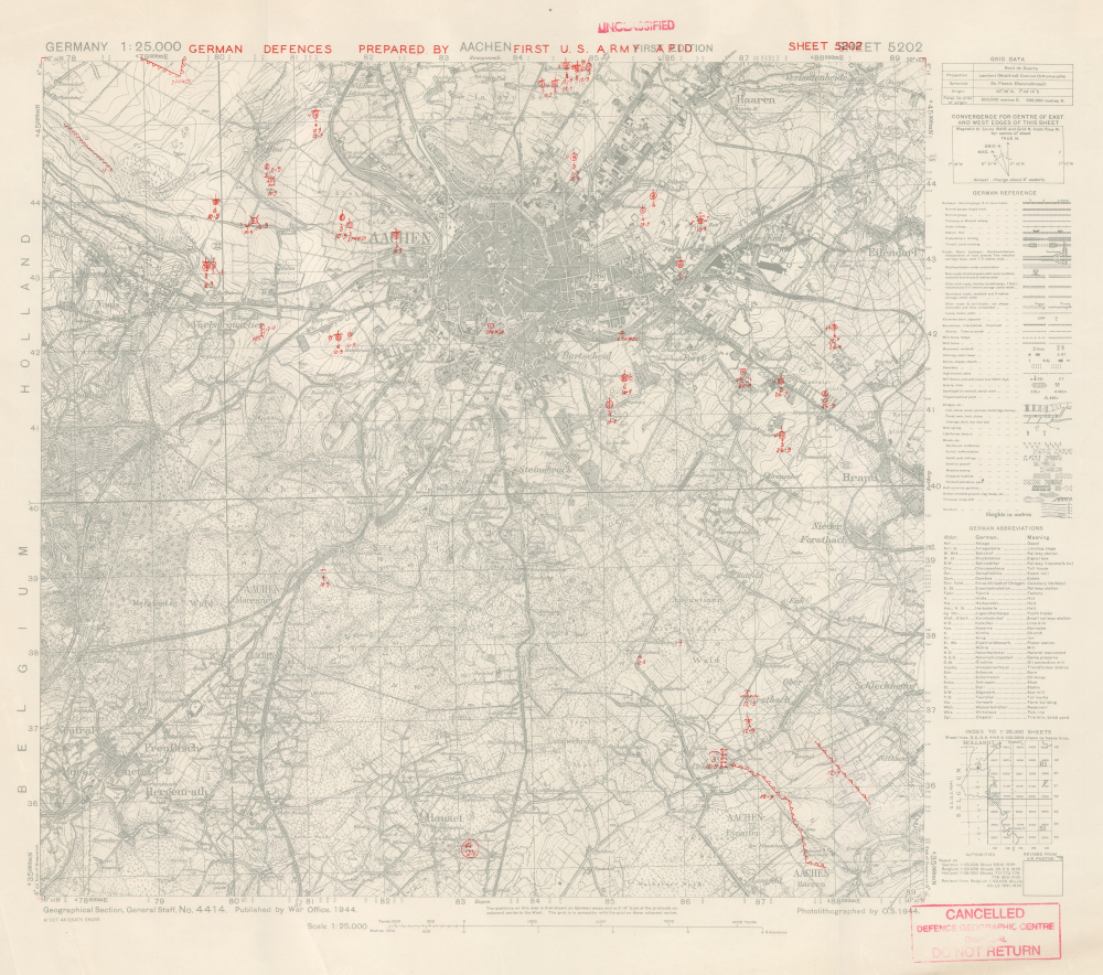
Aachen. German Defences Prepared by First U.S. Army APID. Sheet 5202.
1944 (dated) 20.75 x 22.5 in (52.705 x 57.15 cm) 1 : 25000
1944 (dated) 20.75 x 22.5 in (52.705 x 57.15 cm) 1 : 25000
Description
This is an October 1944 First U.S. Army military situation map of Aachen, Germany, illustrating the defenses around the city as observed from aerial photography. This map was produced only days before the soldiers of the U.S. Army stormed the city and, after three weeks, successfully captured the city from the Germans. Aachen was a strategically important city, but it held greater significance from a psychological perspective. The Holy Roman Emperor Charlemagne was born in Aachen, and Hitler and the Nazis referred to the Holy Roman Emperor as the First Reich. (Hitler referred to his empire as the Third Reich, thus creating a direct line between his regime and the Holy Roman Empire.) Aachen was the first city in Germany captured by the Allies, and this blow must have weighed heavily on Hitler's mind.
The Overprinting
The main point of interest is the red overprinting. Prepared by the First U.S. Army APID (likely, Aerial Photography Interpretation Detachment), the overprinting marks antiaircraft guns, mobile howitzers, searchlights, forts, trenches with firing positions, antitank obstacles, and more. Each enemy position is dated (day-month, so for example September 10 is 10-9). American aerial photograph interpreters thus created this overprinting using aerial photographs taken in early to mid-September for the positions north of Aachen and late September for those south of Aachen. The positions were plotted on maps by the photograph interpreters, converted into standardized notations, printed on maps by an engineer topographic battalion in the field, and distributed to the soldiers (likely the officers and only a select few because no one wanted such sensitive material to fall into enemy hands). This was an extraordinary advancement in military strategy, and the U.S. Army specially trained some of its soldiers to handle it.A Closer Look
The base map labels numerous smaller towns and villages around Aachen, along with churches, and even individual dwellings. Topographic lines illustrate terrain. Aachen's many railway lines are recognizable. A key is included along the right border.The Battle of Aachen
The Battle of Aachen began in mid-September, when the First U.S. Army commenced operations to encircle Aachen. These battles lasted for weeks and faced fierce resistance from the German defenders. The encirclement was nearly complete by the beginning of October when the commanding officer of the First U.S. Army, Lieutenant General Courtney Hodges, ordered the divisions under his command to attack the city itself. Bitter street-to-street and house-to-house fighting ensued, and the battle raged from October 2, 1944, until October 21, 1944, when the German forces defending Aachen unconditionally surrendered to the Americans. The Battle of Aachen was a strategic victory for the Allies. Aachen was the first major German city to be captured by the Allies and secured the communication and supply lines for the First U.S. Army's advance into Germany. However, this victory did come at a heavy cost. American forces suffered approximately 3,500 casualties and did not complete the encirclement, so elements of the German army were able to retreat instead of surrender.Provenance
This map was deaccessioned from the collection of the Defence Geographic Center (DGC) in the United Kingdom. The DGC's history begins in 1803 when the Depot of Military Knowledge was established as part of the British Army. A Topographical Branch was part of the Depot of Military Knowledge and was responsible for military mapping. After several name changes over the following century, the body responsible for military mapping became the Geographical Section, General Staff (GSGS) in 1908. The name changed again to the Directorate of Military Survey in 1943, and the DGC was formed in 2000.Publication History and Census
This map was prepared by the APID of the First U.S. Army and printed by the 654th Engineer Topographic Battalion on October 4, 1944, 2 days after the beginning of the Battle of Aachen. The 654th used a base map compiled by the Geographical Section, General Staff, that was published by the War Office in 1944. This is the only known cataloged example of this map. We know of only 2 similar maps with notations indicating a 'PID' created the red overprinting that have survived: 1 is part of a museum collection in the Netherlands, and the other is in private hands.Cartographer
The British War Office (1857 - 1964) was a department of the British Government responsible for the administration of the Royal Army until 1964, when its functions were transferred to the Ministry of Defense. The War Office was to the Royal Army what the Admiralty was to the Royal Navy, and later, the Air Ministry. Within the War Office, the General Staff Topographical Section was responsible for thousands of maps issued for British intelligence and military use. The Topographical Section was renamed Geographical Section in April 1907. Many, once their military use passed, were offered through licensed agents to the general public. The sole London agent for War Office material was Edward Stanford. More by this mapmaker...
Condition
Very good. Creasing. Closed edge tears. Bears 'Unclassified' stamps.