This item has been sold, but you can get on the Waitlist to be notified if another example becomes available, or purchase a digital scan.
1935 George Philip Pictorial Map of East Africa: Ethiopia, Somalia, and Sudan
Abyssinia-philip-1935$150.00

Title
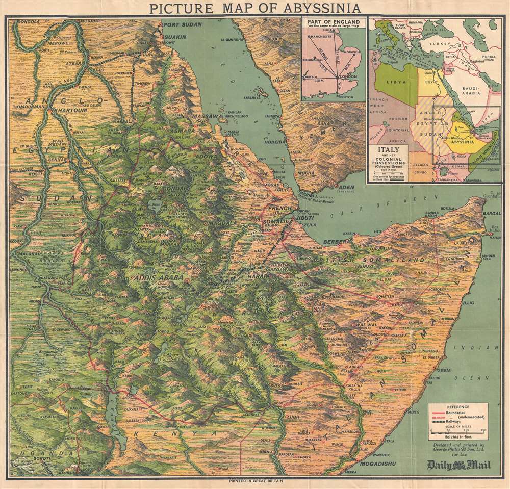
Picture Map of Abyssinia.
1935 (undated) 23.25 x 23.75 in (59.055 x 60.325 cm) 1 : 3801600
1935 (undated) 23.25 x 23.75 in (59.055 x 60.325 cm) 1 : 3801600
Description
This is a 1935 George Philip and Son pictorial map of East Africa at the outset of the Second Italo-Ethiopian War. The map depicts the region from the White Nile in Anglo-Egyptian Sudan to Cape Guardafui and from Port Sudan on the Red Sea to Uganda, Kenya, and southern Somalia, including Mogadishu. Beautifully illustrated, the region's mountainous terrain is highlighted, labeling several mountain summits, and their elevations provided. Myriad cities, towns, and other settlements throughout the region are identified, including Addis Ababa. Railroads are noted and easily identified. An inset map in the upper right corner situates the region with regard to Italy and her other African colonies. A second, smaller, inset map provides the Daily Mail's audience with some understanding of how great the distances are in East Africa by providing a map of England on the same scale.
East Africa Today
Most of the countries identified have since been renamed, including Anglo-Egyptian Sudan, today known as Sudan and South Sudan (two separate nations), French Somaliland (modern-day Djibouti), Abyssinia (Ethiopia), British Somaliland (which is an interesting case, as it is a self-declared state officially known as the Republic of Somaliland that is internationally considered to be an autonomous region of Somalia) and Italian Somaliland (Somalia).The Second Italo-Ethiopian War
The Second Italo-Ethiopian War lasted from October 3, 1935 until February 19, 1937 and was fought between Italy and Ethiopia. Ethiopia was defeated, annexed by Italy, and subjected to a military occupation. Ethiopian leader Haile Selassie, while in exile in England, had unsuccessfully sought aid from the Western democracies until the beginning of World War II. Following Italy's declaration of war on Britain and France in June 1940, Italian dictator Benito Mussolini launched attacks on Commonwealth forces in Egypt, Sudan, Kenya, and British Somaliland, and thus the East African campaign during World War II was opened. It would not be until May 1941 that Ethiopian troops and Selassie would reenter Addis Ababa. Even after the Italian defeat, however, the remnants of the Italian Army and their allies carried on a guerrilla war until the Armistice of Cassibile was signed in September 1943.Publication History and Census
This map was created by the firm of George Philip and Son and published by the Daily Mail in 1935. Today this map is uncommon on the market and in institutional collections with the OCLC identifying just 5 holdings.Cartographer
George Philip (1800 - 1882) was a map publisher and cartographer active in the mid to late-19th century. Philip was born into a Calvinst family in Huntly, Aberdeenshire, Scotland. Around 1819 he apprenticed himself to William Grapel, a Liverpool printer and bookseller. Fifteen years later, in 1834, Philip founded his own Liverpool book and map firm. Philip's earliest cartographic ventures were mostly educational material issued in tandem with John Bartholomew Sr., August Petermann, and William Hughes. In 1848, Philip admitted his son, George Philip Jr. (1823 - 1902) into the firm, renaming it George Philip and Son Ltd. George Philip Jr. ran the firm until his death in 1902, by which time it had developed into a major publishing concern. His successors established the London Geographical Institute, a factory where they embraced modern printing techniques to produce thousands of economical and high quality maps. In April 1988, George Philip & Son was acquired by Octopus Publishing, a branch of Reed International. Nonetheless, today the firm trades and publishes to this day as George Philip and Son. More by this mapmaker...
Condition
Very good. Wear along original fold lines. Verso repairs to centerfold separations. Closed tear extending one half inch professionally repaired on verso. Blank on verso. Attached to original binder.
References
OCLC 54321062.