This item has been sold, but you can get on the Waitlist to be notified if another example becomes available, or purchase a digital scan.
1818 Pinkerton Map of Nubia, Sudan and Abyssinia
Abyssinia-pinkerton-1818$150.00

Title
Abyssinia, Nubia & c.
1818 (undated) 20 x 28 in (50.8 x 71.12 cm)
1818 (undated) 20 x 28 in (50.8 x 71.12 cm)
Description
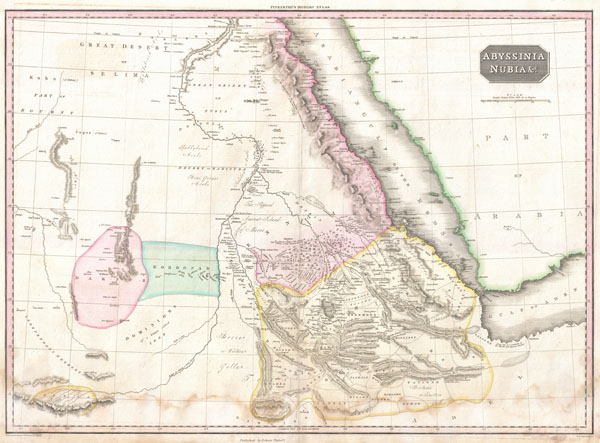
Pinkerton's extraordinary 1818 map of Nubia and Abyssinia. Covers from Darfur east to the Gulf of Aden and from Aswan south to Gingiro. Includes the modern day countries of Sudan, Ethiopia, and Eretria as well as parts of Djibouti, Kenya, Egypt, Yemen and Saudi Arabia.
This map is centered on the southern reaches of the Nile River. Shows the division of the Nile in modern day Sudan between the White Nile, which flows slightly westward and the Blue Nile which flows slightly eastward. The Blue Nile had, by this time, been traced to its source, Lake Tana, in the relatively well mapped Christian kingdom of Abyssinia. The White Nile is shown originating the Mountains of the Moon in the extreme lower left quadrants of this map. The Mountains of the Moon were an apocryphal source for the Nile River speculated upon by as early as Herodotus but more commonly by the second century geographer Claudius Ptolemy. It is a curious decision on the part of Pinkerton to keep the Mountains of the Moon as a source of the White Nile, but abandon the associated lake theory that, ultimately proved to have some relation to reality.
Pinkerton offers numerous interesting notes and commentary throughout. Near the split of the White and Blue Niles, Pinkerton correctly identifies the 'Supposed Ancient Island of Meroe' were today little known but magnificent ancient pyramids were built in imitation of the Egyptian work at Giza. Also notes the site where the 'Portuguese found King David Encamped in 1520' - no doubt referring to one of the many Abyssinian Kings of that name. Also notes the important desert caravan route, with its many oases, between Accad and Aswan.
Upper right hand quadrant features title plate and a scale in British Miles. Drawn by L. Herbert and engraved by Samuel Neele under the direction of John Pinkerton. This map comes from the scarce American edition of Pinkerton's Modern Atlas, published by Thomas Dobson & Co. of Philadelphia in 1818.
CartographerS
John Pinkerton (February 17, 1758 - March 10, 1826) was an Scottish writer, historian, and cartographer. Pinkerton was born in Edinburgh, Scotland. He was a studious youth with a passion for the classics. As a young man, he studied at Edinburgh University before apprenticing as a lawyer. Around this time, he began writing, with his first book, Elegy on Craigmillar Castle published in 1776. Pinkerton moved to London in 1781 to pursue his writing career in earnest. He successfully published several works of literature, poetry, and history. Pinkerton proved passionate in his literary and historical writings, but his correspondence with other cartographers has been labeled as aggressive, even insane. In addition to his work as a writer and historian, Pinkerton was one of the leading masters of the Edinburgh school of cartography which flourished from roughly 1800 to 1830. Pinkerton and his contemporaries (Thomson and Cary) redefined European cartography by abandoning typical 18th century decorative elements such as elaborate title cartouches and fantastical beasts in favor of detail and accuracy. Pinkerton's principle work is Pinkerton's Modern Atlas published from 1808 through 1815 with a special American reissue by Dobson and Co. in 1818. Pinkerton relocated to Paris in 1818, where he managed his publishing business until his death in 1826. More by this mapmaker...
Thomas Dobson (1751 - 1823) was an American publisher active in Philadelphia during the late 18th and early 19th centuries. Dobson was born in Edinburgh, Scotland in 1751 and emigrated to Philadelphia c. 1780. In Philadelphia, he established a successful printing business by republishing edited and updated versions of important British reference materials in matching quality but at a much lower price point. He is best known for publishing the first American edition of the Encyclopedia Britannica. He also published America's first Hebrew Bible. Cartographically Dobson's most notable work is 1818 republication of Pinkerton's fantastic Modern Atlas. Learn More...
Source
Pinkerton, J., A Modern Atlas, from the Lates and Best Authorities, Exhibiting the Various Divisions of the World with its chief Empires, Kingdoms, and States; in Sixty Maps, carefully reduced from the Larges and Most Authentic Sources. 1818, Philadelphia, Thomas Dobson Edition.
Condition
Good condition. Mild to moderate damp staining in lower quadrants. Original centerfold. Blank on verso.
References
Rumsey 0732.58. Phillips (Atlases) 724. National Maritime Museum, 409.