This item has been sold, but you can get on the Waitlist to be notified if another example becomes available.
1966 U.S.G.S. Wall Map of Acadia National Park, Mount Desert Island, Maine
AcadiaNationalPark-usgs-1966$600.00

Title
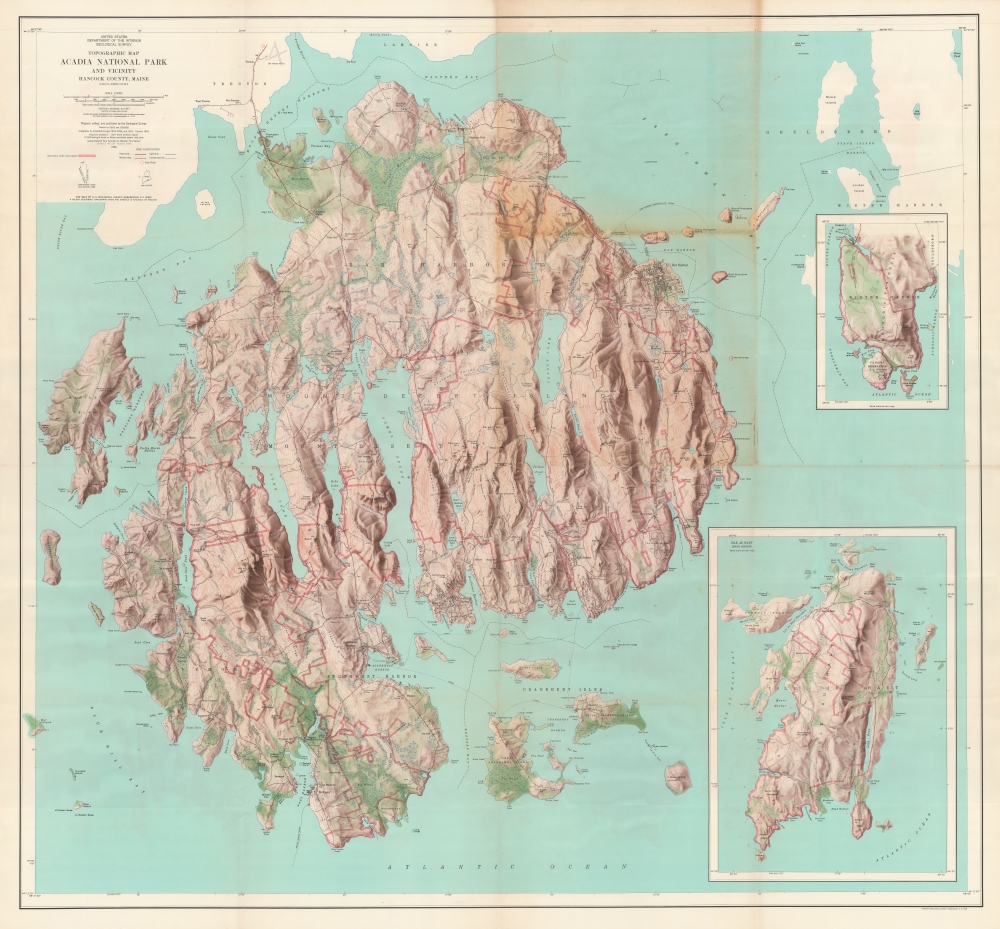
Topographic Map of Acadia National Park and Vicinity Hancock County, Maine.
1966 (dated) 49 x 52.75 in (124.46 x 133.985 cm) 1 : 24000
1966 (dated) 49 x 52.75 in (124.46 x 133.985 cm) 1 : 24000
Description
An extraordinary large-scale 1966 U.S. Geological Survey wall map of Acadia National Park, Mount Desert Island, Maine. This is the best map of the island published in the mid-20th century. The map is unrepresented in the private market as it was produced exclusively for internal administrative use.
A Closer Look
The map is a large polyconic projection detailing Mount Desert Island and adjacent islands included in Acadia National Park. The map is highly detailed, with the island's dramatic topography illustrated using shading and contours. The park's many legendary hiking trails are noted, as are the carriage roads and important buildings. Pink outlines define the park's borders, separating it from privately held land and towns, including Bar Harbor. Insets detail the extra-island portions of Acadia, including nearby Isle au Haute and Winter Harbor.Acadia National Park
Mount Desert Island, so named because of its many bald rocky mountaintops, has been a tourist destination since the mid-19th century when it was discovered by outsiders, artists, journalists, Hudson River School artists, and other patrons, known collectively as the 'Rusticators.' Undaunted by crude accommodations and simple food, they sought out local fishermen and farmers for accommodation and guidance. Summer after summer, the rusticators returned to renew friendships with local islanders and, most of all, to savor the fresh salt air, scenery, and relaxed pace. Soon the villagers' cottages and fishermen's huts filled to overflowing, and by 1880, 30 hotels competed for vacationers' dollars. Tourism was becoming the island's primary industry. Drawing the attention of the wealthy and influential, the island was designated as Sieur de Monts National Monument by President Woodrow Wilson in July 1916. In February 1919, the area's status was officially changed from a National Monument to a National Park, making it the first National Park east of the Mississippi River. With the change to a National Park came a name change as well, to Lafayette National Park. It was not until January 1929 that the park was given its current name, Acadia National Park. Acadia is unlike most other National Parks, as its creation was encouraged by numerous private individuals. One, John. D. Rockefeller, purchased a summer home in Bass Harbor in 1910. Rockefeller began buying up land on the island with the goal of creating a system of carriage roads to make 'one of the greatest views in the world' accessible to all visitors.Publication History and Census
The map was first issued in 1956. It was updated with topographical shading in 1960. The present edition is 1966. We note one copy at the Library of Congress, the 1960 edition, and OCLC records 24 other institutional holdings. Nonetheless, it is extremely rare on the market with no sales records.Cartographer
The Office of the Coast Survey (later the U.S. Geodetic Survey) (1807 - present), founded in 1807 by President Thomas Jefferson and Secretary of Commerce Albert Gallatin, is the oldest scientific organization in the U.S. Federal Government. Jefferson created the "Survey of the Coast," as it was then called, in response to a need for accurate navigational charts of the new nation's coasts and harbors. The first superintendent of the Coast Survey was Swiss immigrant and West Point mathematics professor Ferdinand Hassler. Under the direction of Hassler, from 1816 to 1843, the ideological and scientific foundations for the Coast Survey were established. Hassler, and the Coast Survey under him developed a reputation for uncompromising dedication to the principles of accuracy and excellence. Hassler lead the Coast Survey until his death in 1843, at which time Alexander Dallas Bache, a great-grandson of Benjamin Franklin, took the helm. Under the leadership A. D. Bache, the Coast Survey did most of its most important work. During his Superintendence, from 1843 to 1865, Bache was steadfast advocate of American science and navigation and in fact founded the American Academy of Sciences. Bache was succeeded by Benjamin Pierce who ran the Survey from 1867 to 1874. Pierce was in turn succeeded by Carlile Pollock Patterson who was Superintendent from 1874 to 1881. In 1878, under Patterson's superintendence, the U.S. Coast Survey was reorganized as the U.S. Coast and Geodetic Survey (C & GS or USGS) to accommodate topographic as well as nautical surveys. Today the Coast Survey is part of the National Oceanic and Atmospheric Administration or NOAA. More by this mapmaker...
Condition
Good. Some wear and discoloration on old fold lines, including slight loss at some fold intersections, which has been stabilized on verso.
References
Library of Congress, G3732.A3 1960 .G4 TIL.