1959 U.S. Coast and Geodetic Survey Advertisement for Aeronautical Charts
AeronauticalCharts-uscgs-1959$3,000.00

Title
Aeronautical Charts.
1959 (undated) 21.25 x 16 in (53.975 x 40.64 cm)
1959 (undated) 21.25 x 16 in (53.975 x 40.64 cm)
Description
This is a very rare and possibly unique 1959 map poster advertising aeronautical charts produced by the U.S. Coast and Geodetic Survey (U.S.C.G.S.). As passenger air travel exploded in the postwar period, U.S.C.G.S. charts became an indispensable tool for pilots to ensure as safe and comfortable a ride as possible. This poster, and a similar poster for nautical charts, was issued to advertise U.S.C.G.S. charts.
Early pilots had, roughly speaking, two methods of navigating, one being to use easily identifiable landmarks like cities, rivers, and railroad lines, and the other being dead reckoning, with the possible aid of a compass (these were prone to inaccuracies in the cold temperatures and high altitude aboard planes). Many pilots using the first method compiled homemade map books from existing road maps that could be easily accessed and examined while flying. But these proved cumbersome and inadequate, especially as aviation infrastructure was developing quickly and new airfields were being added every year.
Starting in the late 1920s, Rand McNally and Co. began publishing modified versions of their standard atlas maps of different U.S. states with aeronautical information overprinted, indicting things such as terrain elevation, well-established air routes, airfields, beacon lights, and radio stations. In the mid-1930s, Jeppesen and Co. began to produce dedicated aeronautical charts for commercial aviation, which proved popular with pilots. Other outfits in the U.S. military and U.S. government also began to experiment with producing aeronautical charts, with the most important being the U.S.C.G.S.
In 1926, Congress passed the Air Commerce Act, which, among other things, established an Aeronautic Branch within the Department of Commerce, which undertook a variety of tasks, including the production of aeronautical charts through the U.S.C.G.S. By 1926 the Survey was producing its first 'Air Navigation Maps' (in conjunction with the Ford Motor Company) and by 1930 it was publishing dedicated aeronautical charts with both visual and radio navigational information. The number and geographic coverage of these charts increased dramatically in the following years, and the Survey undertook the ambitious project of publishing sectional aeronautical charts covering the entire country on a consistent scale, as well as a series of world aeronautical charts doing the same.
As with private navigational companies like Jeppesen, the insatiable demand for charts during the World War II (1939 - 1945) led to a nearly unending string of charts being produced for military use. By the end of the war, when commercial aviation was poised for a major increase in passengers and cargo, the U.S.C.G.S. had developed a finely tuned system of navigational aids, symbols, and color-shading that would become like a second language to pilots. The Survey continued to publish aeronautical charts into the Jet Age, even after it was incorporated into the National Oceanic and Atmospheric Administration (N.O.A.A.) upon its creation in 1970, but in 2000 responsibility for the production of aeronautical charts was shifted to the Federal Aviation Administration's National Aeronautical Charting Office.
Presumably, the U.S.C.G.S. itself (or perhaps the National Archives) retains an original from which the reproduction was based, but otherwise the present work may be a unique survival, making this a once-in-a-lifetime opportunity for collectors.
A Closer Look
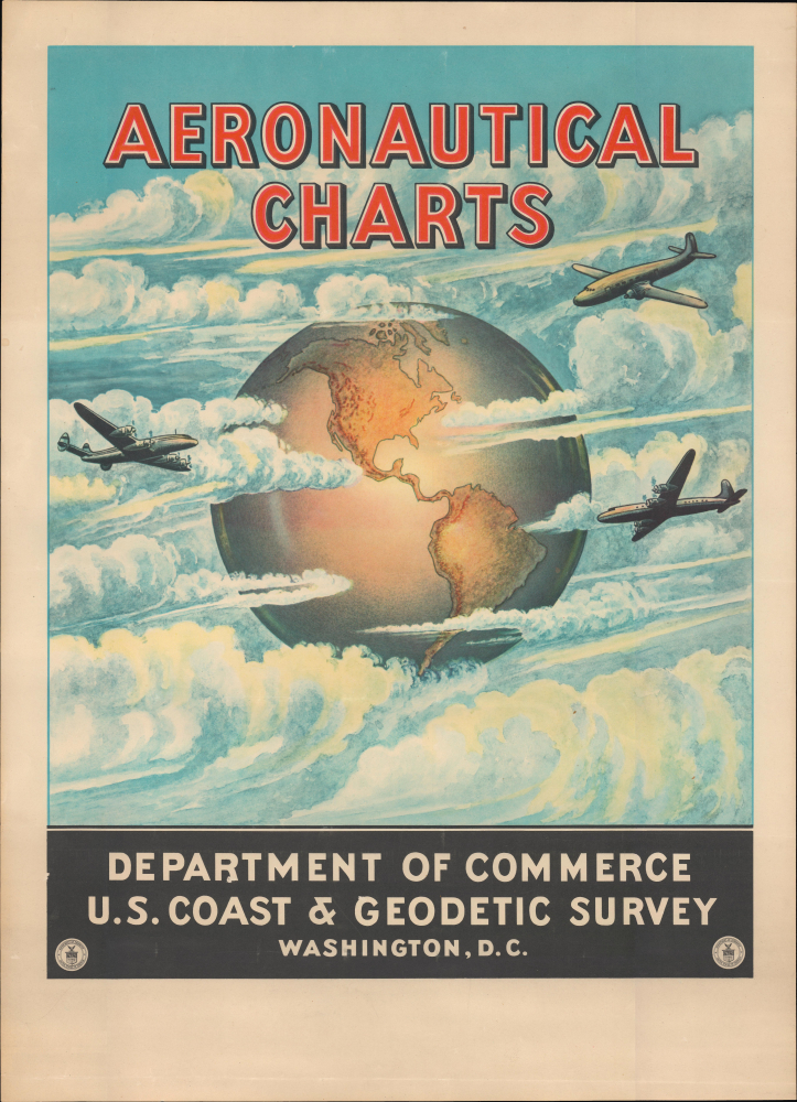
The image consists of three airplanes flying amidst clouds set against a globe centered on the Americas. The plane on the left is a Lockheed Constellation, while that at bottom-right is a Douglas DC-4. The plane at top-right is difficult to pinpoint but is likely a Douglas DC-3, a Martin 4-0-4, or a Convair CV-240 or 340. This advertisment was produced at very cusp of the Jet Age; in fact, as it was issued the planes seen here were beginning to be displaced by the first successful, mass-produced American passenger jets, the Boeing 707 and the Douglas DC-8.The U.S.C.G.S. and Aeronautical Charts
As the field of aviation developed in the early 20th century and planes with more powerful engines were capable of making longer trips, the need arose for navigational aids for pilots. However, these were slow to appear for several reasons, including existing mapmakers' lack of familiarity with the new technology and the difficulties of representing navigational information relevant to pilots in existing formats. Aviation was an incredibly dangerous endeavor in this era; for instance, in the 1919 Transcontinental Reliability and Endurance Test, a great cross-country race of ace pilots, fifty-four accidents and crashes and seven fatalities resulted out of a pool of sixty-four planes and only about half the contestants finished the route in any time frame, many of them taking weeks to avoid flying in dangerous weather.Early pilots had, roughly speaking, two methods of navigating, one being to use easily identifiable landmarks like cities, rivers, and railroad lines, and the other being dead reckoning, with the possible aid of a compass (these were prone to inaccuracies in the cold temperatures and high altitude aboard planes). Many pilots using the first method compiled homemade map books from existing road maps that could be easily accessed and examined while flying. But these proved cumbersome and inadequate, especially as aviation infrastructure was developing quickly and new airfields were being added every year.
Starting in the late 1920s, Rand McNally and Co. began publishing modified versions of their standard atlas maps of different U.S. states with aeronautical information overprinted, indicting things such as terrain elevation, well-established air routes, airfields, beacon lights, and radio stations. In the mid-1930s, Jeppesen and Co. began to produce dedicated aeronautical charts for commercial aviation, which proved popular with pilots. Other outfits in the U.S. military and U.S. government also began to experiment with producing aeronautical charts, with the most important being the U.S.C.G.S.
In 1926, Congress passed the Air Commerce Act, which, among other things, established an Aeronautic Branch within the Department of Commerce, which undertook a variety of tasks, including the production of aeronautical charts through the U.S.C.G.S. By 1926 the Survey was producing its first 'Air Navigation Maps' (in conjunction with the Ford Motor Company) and by 1930 it was publishing dedicated aeronautical charts with both visual and radio navigational information. The number and geographic coverage of these charts increased dramatically in the following years, and the Survey undertook the ambitious project of publishing sectional aeronautical charts covering the entire country on a consistent scale, as well as a series of world aeronautical charts doing the same.
As with private navigational companies like Jeppesen, the insatiable demand for charts during the World War II (1939 - 1945) led to a nearly unending string of charts being produced for military use. By the end of the war, when commercial aviation was poised for a major increase in passengers and cargo, the U.S.C.G.S. had developed a finely tuned system of navigational aids, symbols, and color-shading that would become like a second language to pilots. The Survey continued to publish aeronautical charts into the Jet Age, even after it was incorporated into the National Oceanic and Atmospheric Administration (N.O.A.A.) upon its creation in 1970, but in 2000 responsibility for the production of aeronautical charts was shifted to the Federal Aviation Administration's National Aeronautical Charting Office.
Publication History and Census
This poster promoting the aeronautical charts of the U.S.C.G.S. was produced in 1959. It is extremely rare, with no examples being listed in institutional collections and none known to have come to market. A reproduction of the present poster was issued by the N.O.A.A. in the 1970s or 1980s (Rumsey 15982.000, OCLC 53942807) and even these are rare today. This work was one of two issued by the U.S.C.G.S. in 1959, the other being a similar advert, equally rare and also reproduced in the 1970s or 1980s (Rumsey 15981.000), for 'Nautical Charts' with an illustration of a steamer instead of airplanes.Presumably, the U.S.C.G.S. itself (or perhaps the National Archives) retains an original from which the reproduction was based, but otherwise the present work may be a unique survival, making this a once-in-a-lifetime opportunity for collectors.
Cartographer
The Office of the Coast Survey (1807 - present) founded in 1807 by President Thomas Jefferson and Secretary of Commerce Albert Gallatin, is the oldest scientific organization in the U.S. Federal Government. Jefferson created the "Survey of the Coast," as it was then called, in response to a need for accurate navigational charts of the new nation's coasts and harbors. The spirit of the Coast Survey was defined by its first two superintendents. The first superintendent of the Coast Survey was Swiss immigrant and West Point mathematics professor Ferdinand Hassler. Under the direction of Hassler, from 1816 to 1843, the ideological and scientific foundations for the Coast Survey were established. These included using the most advanced techniques and most sophisticated equipment as well as an unstinting attention to detail. Hassler devised a labor intensive triangulation system whereby the entire coast was divided into a series of enormous triangles. These were in turn subdivided into smaller triangulation units that were then individually surveyed. Employing this exacting technique on such a massive scale had never before been attempted. Consequently, Hassler and the Coast Survey under him developed a reputation for uncompromising dedication to the principles of accuracy and excellence. Unfortunately, despite being a masterful surveyor, Hassler was abrasive and politically unpopular, twice losing congressional funding for the Coast Survey. Nonetheless, Hassler led the Coast Survey until his death in 1843, at which time Alexander Dallas Bache, a great-grandson of Benjamin Franklin, took the helm. Bache was fully dedicated to the principles established by Hassler, but proved more politically astute and successfully lobbied Congress to liberally fund the endeavor. Under the leadership of A. D. Bache, the Coast Survey completed its most important work. Moreover, during his long tenure with the Coast Survey, from 1843 to 1865, Bache was a steadfast advocate of American science and navigation and in fact founded the American Academy of Sciences. Bache was succeeded by Benjamin Pierce who ran the Survey from 1867 to 1874. Pierce was in turn succeeded by Carlile Pollock Patterson who was Superintendent from 1874 to 1881. In 1878, under Patterson's superintendence, the U.S. Coast Survey was reorganized as the U.S. Coast and Geodetic Survey (C & GS) to accommodate topographic as well as nautical surveys. Today the Coast Survey is part of the National Oceanic and Atmospheric Administration or NOAA as the National Geodetic Survey. More by this mapmaker...
Condition
Very good. Slight creasing.
References
Lancaster, J., The Great Air Race: Glory, Tragedy, and the Dawn of American Aviation, (Liveright) 2022.