
This item below is out of stock, but another example (left) is available. To view the available item, click "Details."
Details
1827 Vandermaelen map of Afghanistan and the Hindu Kush
$750.00
1827 Vandermaelen map of Afghanistan and the Hindu Kush
Afghanistan-vandermaelen-1827$325.00

Title
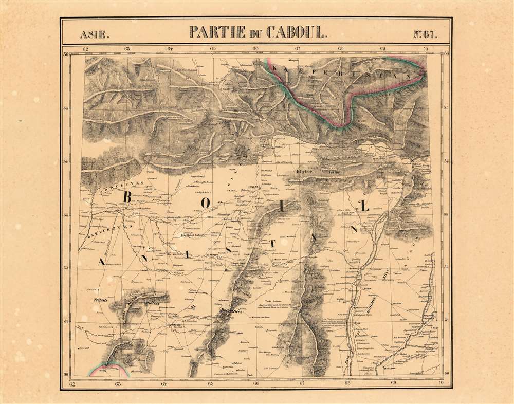
Partie du Caboul Asie no.67.
1827 (undated) 18.5 x 19.25 in (46.99 x 48.895 cm) 1 : 1641836
1827 (undated) 18.5 x 19.25 in (46.99 x 48.895 cm) 1 : 1641836
Description
This is the 1827 Vandermaelen map of the Afghanistan, Pakistan and the Hindu Kush. It is the first large-scale atlas map to focus on the area, and the first to be executed in lithography. The map's detail - drawn from the first-hand exploration of John Macdonald Kinneir on behalf of the British East India Company - would not be improved upon until the First Anglo-Afghan War.
The Theatre of the Anglo-Afghan War
This mountainous region of Afghanistan would prove to be the focal point of 'The Disaster in Afghanistan.' All the major cities where actions occurred are shown, with the roads connecting them well detailed: Quetta, Kandahar, Ghazni, Cabul and Jalalabad all are shown along with the neighboring villages, passes, and roads. The Indus River Valley is shown with numerous cities in Pakistan, including Peshawar and Multan (Moulton on the map.) No earlier map focuses so narrowly on this region with comparable detail.Afghanistan's Tribal Divisions
European explorers, diplomats and historians alike were baffled by the multiplicity of Afghan tribes, to the great detriment of their efforts to exploit the region. Kinneir, exploring the region for the East India Company and distressed at the expansion of Russian influence so close to the British sphere in India, recorded many of these and the data is preserved here on Vandermaelen's map. The principal power in the region at the time of the Afghan war - the Durrani tribe - are represented here by their mixed tributaries (Tributs Melees de Dooranees).The Ghilji tribe, now considered the most powerful of the Pashtuns, are shown as well (Gilzye on the map.) Other tribes named include the Populzyes, Barakzai (Baruckzyes and Bungeesh.Dost Mohammad Khan
The map shows a territory, along the course of the Indus River, marked 'Pays de Mahomet Khan'. This refers to Dost Mohammed Khan, who in 1826 would become Emir of Afghanistan, and would be the principal ruler of Afghanistan during the First Anglo-Afghan War. THe base of his power is apparent throughout this map. His father had been chief of the Barakzai tribe, and had been a civil servant under the Durrani dynasty. This map shows the positions of the most powerful tribal forces in the region just prior to the advent of 'The Great Game.'The Great Game - the struggle for Afghanistan
From 1830 until 1895, a political and diplomatic confrontation, known as 'The Great Game', existed between the British Empire and the Russian Empire over Afghanistan and other territories in Central and Southern Asia. 'The Great Game', as it is known, was ignited due to Russian fears that Britain was making commercial and military inroads in Central Asia, while Britain mutually feared Russia adding 'the jewel in the crown' (India) to its vast empire in Asia. Several wars were fought, including the First Anglo-Afghan War in 1838, the First Anglo-Sikh War in 1845, the Second Anglo-Sikh War in 1848, and the Second Anglo-Afghan War in 1878, along with the Russian annexations of Khiva, Bukhara, and Kokand. Per historians, the Great Game ended on September 10, 1895 with the signing of the Pamir Boundary Commission protocols, which defined the border between Afghanistan and the Russian Empire.Publication History
This map appeared in the second part, 'Asie,' of Vandermaelen's Atlas universel de géographie physique, politique, statistique et minéralogique. The atlas was produced in one edition in 1827; only 810 complete sets were sold. The full set of six volumes appears in eleven institutional collections in OCLC; the 2nd volume alone is listed in 12. This separate map does not appear physically in any listing in OCLC.CartographerS
Philippe Marie Guillaume Vandermaelen (December 23, 1795 - May 29, 1869) was a Flemish cartographer active in Brussels during the first part of the 19th century. Vandermaelen is created with "one of the most remarkable developments of private enterprise in cartography," namely his remarkable six volume Atlas Universel de Geographie. Vandermaelen was born in Brussels in 1795 and trained as a globe maker. It was no doubt his training as a globe maker that led him see the need for an atlas rendered on a universal scale in order that all bodies could be understood in relation to one another. In addition to his great work Vandermaelen also produced a number of globes, lesser maps, a highly detailed 250 sheet map of Belgium, and several regional atlases. More by this mapmaker...
Sir John Macdonald Kinneir (February 3, 1782 - June 11, 1830) was a Scottish army officer of the East India Company, diplomat and traveller. In 1804 he was appointed ensign in the Madras infantry, and posted in 1807 as lieutenant. He was attached to Sir John Malcolm's mission in Persia between 1808–9, during which time he travelled widely. He produced a Gazetteer of Persia in 1813, which for many years remained the best source of geographical data for that part of the world. In 1824 he was appointed envoy to Fath-Ali Shah Qajar of Persia, for the East India Company, arriving in time for the Russo-Persian War (1826–28). Learn More...
Source
Vandeermaelen, P. Atlas universel de geographie physique, politique, statistique et mineralogique (Bruxelles, Vandermaelen) 1827.
Atlas Universel de Geographie. This great work, featuring some 378 unique maps and compiled over three years, was the first lithograph atlas, and the first to render the world on the same projection and at a uniform scale. It was no doubt Vandermaelen’s training a globe maker that led him see the need for an atlas rendered uniformly so that all bodies could be understood in relation to one another. As a result, many newly emerging areas received more attention than prior efforts. Maps of the American West, in particular, benefited: ‘no mapmaker had previously attempted to use such a large scale for any western American area.’ (Wheat). Central and South Asia also appear in sharper focus. Despite Vandermaelen’s reliance upon existing sources, his maps very frequently provided the clearest depictions available of many poorly-understood parts of the world. The atlas was an expensive production, costing $800 in 1827. Subscription lists indicate that only 810 full sets of the atlas were sold. It was printed on high-quality paper with superior hand coloring and was engraved in a clear, legible style. Conjoined, the maps of Vendermaelen's atlas would create a massive globe some 7.75 meters in diameter, a feat which was accomplished at the Etablissement Geographique de Brussels.
Condition
Very good condition. Some toning and freckling.
References
Rumsey 2212.000 No physical copies in OCLC.