1885 Concanen Bird's-Eye View Map of Afghanistan and Central Asia
AfghanistanCentralAsia-concanen-1885$2,200.00

Title
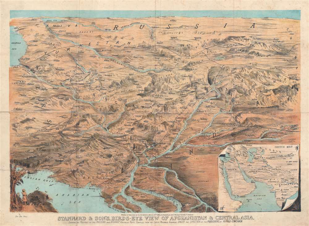
Stannard and Son's Bird's-Eye View of Afghanistan and Central Asia.
1885 (dated) 21.5 x 28 in (54.61 x 71.12 cm)
1885 (dated) 21.5 x 28 in (54.61 x 71.12 cm)
Description
This is a rare 1885 Alfred Concanen bird's-eye view map of Central Asia. Karachi, the Indus River Delta, and the Persian Gulf occupy the foreground and India, Iran, Afghanistan, reach toward the horizon, with Russia in the background. The Caspian Sea appears along the left border. Numerous important cities, including Kabul (Cabul), Samarkand, Bukhara, Tehran, Isfahan, Kandahar, Srinagar, and Hyderabad are all labeled, along with many others. Mountain ranges and mountain passes are identified.
The Panjdeh Incident
Russia had been slowly expanding into Central Asia since the 1873 invasion and annexation of Khiva. They began moving into modern-day western Turkmenistan in 1881 and by March 1884 held most of modern Turkmenistan. Russian incursion near the northern frontiers of Afghanistan concerned both the Amir of Afghanistan and the British Raj. By extension, the Britain felt that its control of India was threatened, since a likely path for a Russian invasion of India was south through Herat, Kandahar, and Quetta in Afghanistan. In what has become known as the Panjdeh Incident, known as the Battle of Kushka in Russian historiography, Russian troops attacked and captured an Afghan outpost at Ak Tepe on March 30, 1885. While Britain saw this as an overt act that would likely lead to war, Czar Alexander III of Russia suggested arbitration and Britain accepted. This years-long series of negotiations led to the formal establishment of the northeastern border of Afghanistan, roughly where it is today.The Great Game
'The Great Game' was a diplomatic confrontation between the British and Russian Empires over Afghanistan and other territories in Central and Southern Asia. The conflict, rooted in long-standing animosity between Russia and Britain, revolved around Afghanistan, which, while lacking significant resources of its own, was strategically situated. For its part, Russia feared Britain was making commercial and military inroads into Central Asia, an area long within the sphere of influence of St. Petersburg. Britain, conversely, feared Russia making gains in India, 'the jewel in the crown' of British Asia. The escalating tensions led to several wars and proxy wars: The First Anglo-Afghan War (1839 - 1842), the First Anglo-Sikh War (1845 - 1846), the Second Anglo-Sikh War (1848 - 1849), and the Second Anglo-Afghan War (1878 - 1880), along with the Russian annexations of Khiva, Bukhara, and Kokand. Then as now, Afghanistan proved a grinding stone upon which the world's great empires diminished themselves, none achieving a definitive victory despite committing staggering resources. The Great Game 'ended' on September 10, 1895, with the signing of the Pamir Boundary Commission Protocols, which stabilized the border between Afghanistan and the Russian Empire - but well into the 20th century the British were well aware the conflict remained. Regarding the attitude of Afghans to the British and to the Russians, the general assumption of the British was that 'Some will fight for us, some against us, but all will fight.'War as Art
Lithograph 'seat of war' perspective views began to appear in Europe in the 1840s. At the time, cartography, although widely disseminated, rarely offered significant regional detail. Such information, particularly in time of war, would have been considered valuable state-controlled secrets. Nonetheless, the rise of news-consumption, general literacy, and economical printing techniques created a voracious appetite for cartographic knowledge. In addition, active war engendered passionate interest on the home front - where are our boys? Recognizing an opportunity, European commercial lithographers began to illustrate European wars using expansive bird's-eye style views, which enabled readers to understand the geographic deportment, terrain, and character of contested territories. Such views were often printed as brilliant multi-color chromolithographs, on heavy stock, meant for framing and prominent display. While the tradition of 'seat of war' views was pioneered in Europe, 48ers fleeing the failed Springtime of the People revolutions of 1848 - 1849, carried the art form to the United States, where it became a popular way of illustrating the American Civil War (1861 - 1865). Later, following the Civil War, it transformed into a nation-wide industry of viewmaking, with a focus on real-estate promotion and urban panoramas.Chromolithography
Chromolithography is a color lithographic technique developed in the mid-19th century. The process involved using multiple lithographic stones, one for each color, to yield a rich composite effect. Oftentimes, the process would start with a black basecoat upon which subsequent colors were layered. Some chromolithographs used 30 or more separate lithographic stones to achieve the desired effect. Chromolithograph color could also be effectively blended for even more dramatic results. The process became extremely popular in the late 19th and early 20th centuries, when it emerged as the dominate method of color printing. The vivid color chromolithography produced made it exceptionally effective for advertising and propaganda imagery.Publication History and Census
This map was created by Alfred Concanen and printed and published by Stannard and Son in 1885. We note a single example cataloged in OCLC which is part of the collection at The British Library.CartographerS
Alfred Concanen (May 1835 - December 10, 1886) was a British publisher and lithographer active in London, England, in the second half of the 19th century. Concanen was of Northern Irish stock from the Galway region, but was born in Nottingham, England. His father Edward John Concanen (1804 - 1868) was a noted 'engineering artist' and portraitist. It is unclear where Concanen learnt lithography, but it is likely that he was trained by his father. As early as 16, Concanen is recorded as working as an attorney's clerk. Concanen worked for several years with the Illustrated Sporting and Dramatic News. In the 1850s he partnered with Thomas Wales Lee (1833 - 1910) and Henry Herepath Siebe (1832 - 1887) publishing under the imprints of 'Concanen, Lee and Siebe' and 'Concanen, Siebe and Co.' Lee left the firm in February 1865 and Concanen himself in December 1866. He also began publishing on his own, issuing sheet music covers, in 1860. While Concanen is most famous for his sheet music and theater broadsides, he did dabble in chromolithograph 'seat of war' views in partnership with Stannard and Son from about 1870. Described as 'slight of build with a fair full moustache, something of a dandy, good natured, generous, a play copy of the lions comiques whom he immortalized in his lithographs.' His studio was located at 12, Frith Street, Soho, London. Concanen died suddenly in 1886 after a post-theater visit to a pub on the strand. More by this mapmaker...
William Thomas Stannard (December 15, 1815 - November 23, 1895) was a lithographic printer active in London during the second half of the 19th century. Stannard was born in London, the son of a postal worker. Stannard published initially in partnership with 'Rae' as 'Stannard and Rae' and alone as 'Stannard and Co.' In 1847, he entered into partnership with Francis Dixon as 'Stannard and Dixon', an imprint that remained active until June of 1868, when the partnership dissolved. At this time, Stannard's son, William Stannard (1848 - 1895), joined the firm, which was reestablished as 'Stannard and Son.' This father-son partnership remained active until November of 1891. From 1870, he employed the artist and lithographer Alfred Cancanen to issue numerous striking panoramic 'seat of war' views. In his personal life Stannard was a known philanderer who kept two households, one with his wife Catherine Jane Bowskill (1821 - 1887) and another with his mistress Selah Sands (1831 - 1905). Shortly after Stannard's death, the firm was liquidated at auction. Learn More...
Condition
Good. Wear along original fold lines. Verso repairs to fold separations and at a fold intersection. Silked, but still vivid. Light soiling.
References
OCLC 497540028.