This item has been sold, but you can get on the Waitlist to be notified if another example becomes available, or purchase a digital scan.
1600 Arnoldo de Arnoldi Lafreri School Map of Africa
Africa-arnoldi-1600$2,250.00

Title
Africa.
1600 (undated) 15.5 x 19.5 in (39.37 x 49.53 cm) 1 : 24000000
1600 (undated) 15.5 x 19.5 in (39.37 x 49.53 cm) 1 : 24000000
Description
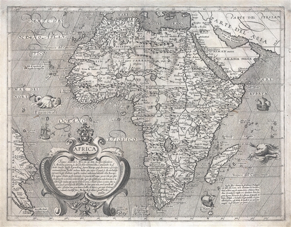
An extremely rare separately issued c. 1600 Lafreri school map of Africa by Fiamengo Arnoldo di Arnoldi. Arnoldi's map covers the continent of Africa in full, as well as parts of the adjacent Arabian Peninsula (modern day Saudi Arabia), and across the Atlantic, Brazil. A fabulous title cartouche appears in the lower left with a long textual annotation describing Africa, including such qualities as the continent's scarcity of water, strange beasts, and extreme heat. There are two particularly ferocious sea monsters and three ships at sail.
Cartographically Arnoldi derived this map from Abraham Ortelius' 1570 map of Africa. Note how Zanzibar appears on the west coast of Africa just south of the Congo – a featured shared with Ortelius' map. Also like Ortelius' map, the Nile follows the Ptolemaic model drawing its waters from to great lakes in the southern part of the continent, Zember (Lake Zaire) and Zaflan. Where Arnoldi differs from Ortelius is he addition of copious annotations throughout the map describing various places and historical discoveries.
Arnoldi's name appears nowhere on this map, but we are able to date and deduce its origins from evidence on the map itself. Stylistically and in terms of content it is part of Arnoldi's known map set of the four continents. The map of Europe from this set bears Arnoldi's name, as well as that of the printer, Matteo Florimi of Sienna. Arnoldi worked with Florimi only in the final years of his life, 1600 – 1602, so we can firmly date the map to these years. The armorial crest, situated over the cartouche, is identical to a similar crest appearing on the Europe map from Arnoldi's continental series, and belongs to the Siena writer Scipione Bargaglia, Armoldi's patron. The John Carter Brown library has the only known full set of Arnoldi's continent maps. Known examples of this map are held in only three collections, the afore mentioned JCB Library, the Library of Congress, and The Bibliothèque Nacionale de France.
All of Arnoldi's work is extremely rare and highly desirable. Of his four continent maps, the Africa map appears to be the rarest, having appeared on the market only once in the last 30 years.
CartographerS
The British Admiralty Office (1795 - Present) or the United Kingdom Hydrographic Office refers to the Branch of the English government that is responsible for the command of the British Navy. In 1795 King George III created the United Kingdom Hydrographic Office, known in short as the U.K.H.O., to provide top notch nautical charts to the vast Royal Navy. Prior the founding of the Admiralty the surveying and creation of nautical charts was primarily a commercial venture wherein the cartographer himself, more of than not, actually financed the printing of his own material. The great navigator Cook himself is known to have scrambled for funds to publish his own seminal charts - the most important and advanced of the period. The system of privately funded nautical mapping and publishing left vast portions of the world uncharted and many excellent charts unpublished. King George III, responding significant loss in trade revenue related to shipwrecks and delay due to poor charts, recognized the need for an institutionalized government sponsored cartographic agency - the Admiralty. The first head of the Admiralty, a position known as Hydrographer, was the important cartographer Alexander Dalrymple. Dalrymple started by organizing and cataloging obtainable charts before initiating the laborious process of updating them and filling in the blanks. The first official Admiralty Chart appeared in 1800 and detailed Quiberon Bay in Brittany. By 1808 the position of Hydrographer fell to Captain Thomas Hurd. Hurd advocated the sale of Admiralty charts to the general public and, by the time he retired in 1829, had issued and published some 736 charts. Stewardship of the organization then passed to Rear Admiral Sir Francis Beaufort. It was under Beaufort's administration that the Admiralty truly developed as a "chart making" as opposed to a "chart cataloging" institution. Beaufort held his post from 1829 to 1854. In his 25 years at the Admiralty Beaufort created nearly 1500 new charts and sponsored countless surveying and scientific expeditions - including the 1831 to 1836 voyage of the H.M.S. Beagle. By 1855 the Admiralty's chart catalog listed some 1,981 charts. More by this mapmaker...
Matteo Florimi (1540 – April 13, 1615) was an Italian print seller, book dealer, printer, and publisher. Florimi was born in Calabria around 1540. He relocated to Siena around 1501 where he established a prosperous workshop known or books, allegorical prints, floral prints, and maps. Around 1600 he acquired the services of Arnoldo di Arnoldi, a map engraver previously employed with Giovanni Antonio Magini. In that same year, Magini accused Florimi of plagiarism, an event that is most likely associated with Arnoldi's defection. In the years 1605-1608, Florimi received financial support from Ottavio Cinuzzi. He was also known to be close friends with the Italian mannerist painter Francesco Vanni. Florimi's cartographic work is often found in Lafreri atlases. Florimi was survived by his four children, Giovanni, who continued his father's workshop under the imprint 'Eredi Florimi'; Francesco, Cecila, and Caterina. Learn More...
Condition
Very good. Expert repair, upper margin. Blank on verso. Platemark visible.
References
OCLC 60763283. Brown University, John Carter Brown Library, Cabinet A60 Ar 3. Betz, R., The Mapping of Africa A Cartobibliography of Printed Maps of the African Continent to 1700, #45.1. Norwich, O. I., Norwich's Maps of Africa: An Illustrated and Annotated Cartobibliography, #26