1796 Carey Map of Africa
Africa-carey-1796$300.00

Title
Africa according to the best authorities.
1796 (undated) 16.25 x 17 in (41.275 x 43.18 cm) 1 : 20275000
1796 (undated) 16.25 x 17 in (41.275 x 43.18 cm) 1 : 20275000
Description
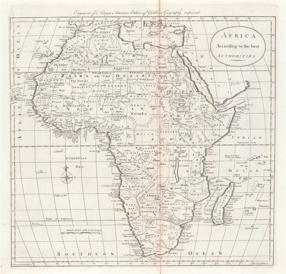
This is a 1796 map of Africa from Carey's General Atlas, the first atlas published in the new American Republic. It was made at the height of the Transatlantic Slave Trade and the transformation of the institution of slavery in the early Republic.
A Closer Look
The map is quite detailed, particularly along the coast of West Africa, where Europeans had the longest presence and greatest knowledge. Even the interior of Africa is mapped in some detail, although the geography of some regions, such as the Great Lakes, was not well understood (it would be nearly a century before it was). A point in 'Upper Ethiopia' is correctly labelled as 'head of the Nile,' referring to James Bruce's visit to Lake Tana in 1770. The sources and full course of the White Nile, here identified as the 'White River', remain ambiguous. The Islands north of Madagascar belonging to the Outer Seychelles are exaggerated in size, likely due to their importance for navigation. No mention or indication of European colonialism is made, aside from naming forts, while indigenous empires like Angola and Kongo (Congo) are noted. Sporadic notes appear throughout, like 'gold mines,' 'gum forest,' 'a savage people,' and 'men eaters' (a reference to lions). One interesting feature is the use of Philadelphia, where it was engraved and published, as the prime meridian.The Early Republic and the Transatlantic Slave Trade
This map was produced at the height of the Transatlantic Slave Trade, when tens of thousands of people were forcibly transferred every year across the Atlantic to various points in the New World, including directly to the newly-independent United States. The issue of slavery was one of the great vexing questions in the early American Republic. Although most of the founding fathers regarded it as morally indefensible and bound to disappear, they also were personally and as a class reliant on the institution. The Constitution had arranged for the direct importation of slaves to cease in 1808, but human trafficking from the Caribbean and the domestic slave trade continued after this date. Although northern states gradually abolished slavery and its abolition was feasible in the Upper South, the economy of the Deep South became more and more dependent on slavery as the 19th century progressed, while the Haitian Revolution and fears of rebellion led slaveowners to employ ever greater violence and brutality to maintain control. As time went on, not only did the 'peculiar institution' not die, but became more entrenched and expanded westwards, increasing the tensions that ultimately led to the U.S. Civil War.Publication History and Census
This map is likely from the 1796 edition of Carey's General Atlas (sometimes subtitled American Edition of Guthrie's Geography improved), multiple editions of which were printed between 1795 and 1818. The prevalence of the map is difficult to determine since the map is not always cataloged with the year recorded, but aside from the edition in the Rumsey Collection, the 1796 edition of the entire atlas is held by a handful of universities and research institutions in the United States and elsewhere.CartographerS
Matthew Carey (January 28, 1760 - September 16, 1839) was a Dublin born publisher who established himself in Philadelphia in the late 18th and early 19th century. A young man of socially progressive views, Carey's first known publication, produced when he was but 17 years old, was a pamphlet criticizing dueling. Another pamphlet, issued in the same year, attacked the Irish penal code. Shortly afterwards, in 1779, legal issues, possibly arising from his liberal political activism, forced Carey to flee to Paris. In Paris, Carey had the good fortune to befriend the visiting American diplomat and founding father, Benjamin Franklin (1706 - 1790). As an Irishman chafing under the rule of England, Carey sympathized with and admired the American revolutionary. The liberally minded pair struck up a lifelong friendship and Carey was hired to work at Franklin's press in Passy, France. A year later, Carey returned to Ireland and resumed his politically provocative publishing career with The Freemans's Journal and The Volunteer's Journal. It didn't take long for political pressure to once again force Carey from Ireland - this time to America (1784). Although largely without funds, Carey convinced Gilbert du Motier, Marquis de Lafayette (1757 - 1834), who he knew from Franklin's Paris circle, to lend him funds to establish a new publishing concern in Philadelphia. Despite this loan, Carey's firm remained under financed and opened on a shoestring budget. It was most likely his limited budget that led Carey to some of his most important publishing innovations. At the time cartographic publishing was dominated by large printing houses in London and Paris where most, if not all, of the work was completed in house. Without the finances to emulate this large publishing houses, Carey was forced to outsource much of his publishing work. This set the stage for subsequent American publishers who, in order to compete effectively with European firms, relied on an often bewildering network of alliances and collaborations. Carey was also a master of republishing many of his own maps in multiple different atlases and formats to maximize their profitability. His most important work is without a doubt the 1795 issue of the American Atlas the first atlas to be published in America. Carey died in 1839 but was succeeded by his son Henry Charles Carey (1793 - 1879) who, in partnership with his brother-in-law Isaac Lea (1792 - 1886), published numerous important maps and atlases under the Carey and Lea, Lea Brothers, and Lea and Blanchard imprints. More by this mapmaker...
William Guthrie (1708 - March 9, 1770) was a Scottish historian, journalist, and writer. Born in Brechin, he studied at Aberdeen University with the idea of becoming a parochial schoolmaster. Instead, in 1730, he elected to settle in London and try his hand at literature. He covered parliamentary debates f or the Gentleman's Magazine and soon earned a reputation for being a political writer. He published several scholarly works, including a History of England from the Invasion of Julius Caesar to 1688 in four volumes, and, most notably, his Geographical Historical, and Commercial Grammar. Learn More...
Source
Carey, M., Carey's General Atlas, (Philadelphia: Carey) 1796.
Condition
Good. Wear along edges, reinforcement and toning along central fold line.
References
Rumsey 2862.022; OCLC 984129169.