This item has been sold, but you can get on the Waitlist to be notified if another example becomes available, or purchase a digital scan.
1691 Coronelli Map of Africa
Africa-coronelli-1691$3,250.00

Title
L'Africa Divisa nelle sue Parti secondo le Piùu moderne relationi colle scoperte dell' origine, e coro del NILO, descritta dal P.M. Coronelli M.C. Cosmografo della Serenissima Republica di Veneia è dedicata all' Eccellenza del Signor Gran Contestabile Colonna gia Vce. Rè d' Aragona, poi Vce Rè di Napoli.
1691 (undated) 24 x 17.75 in (60.96 x 45.085 cm) 1 : 13300000
1691 (undated) 24 x 17.75 in (60.96 x 45.085 cm) 1 : 13300000
Description
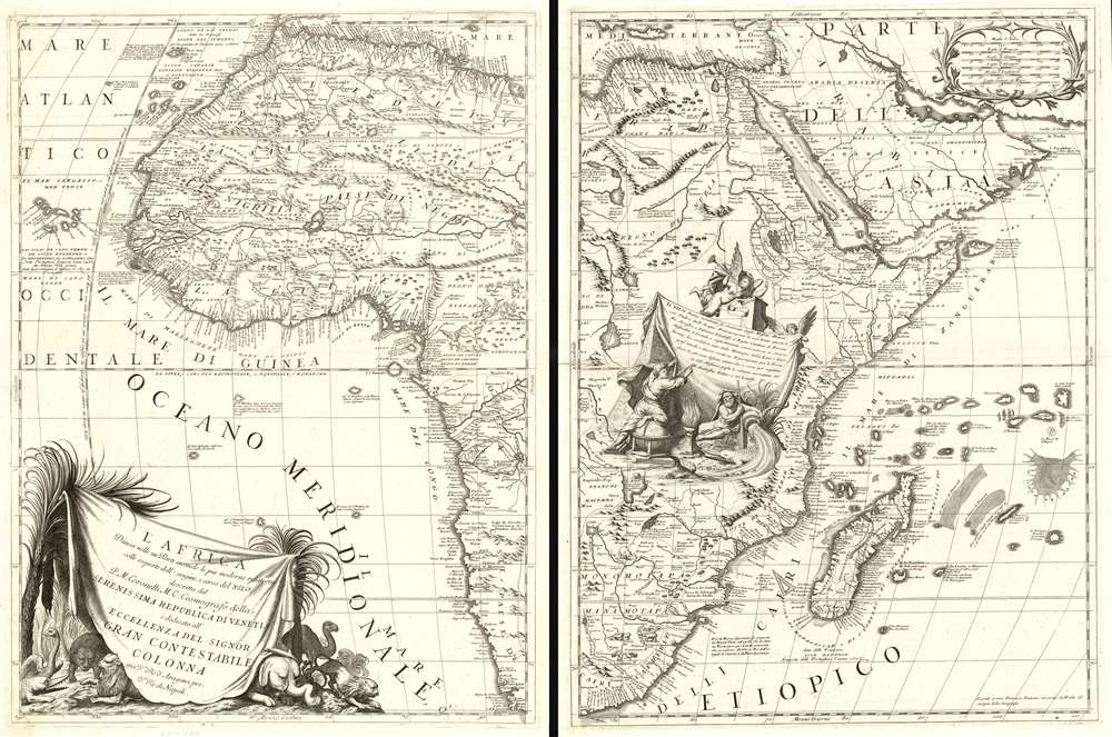
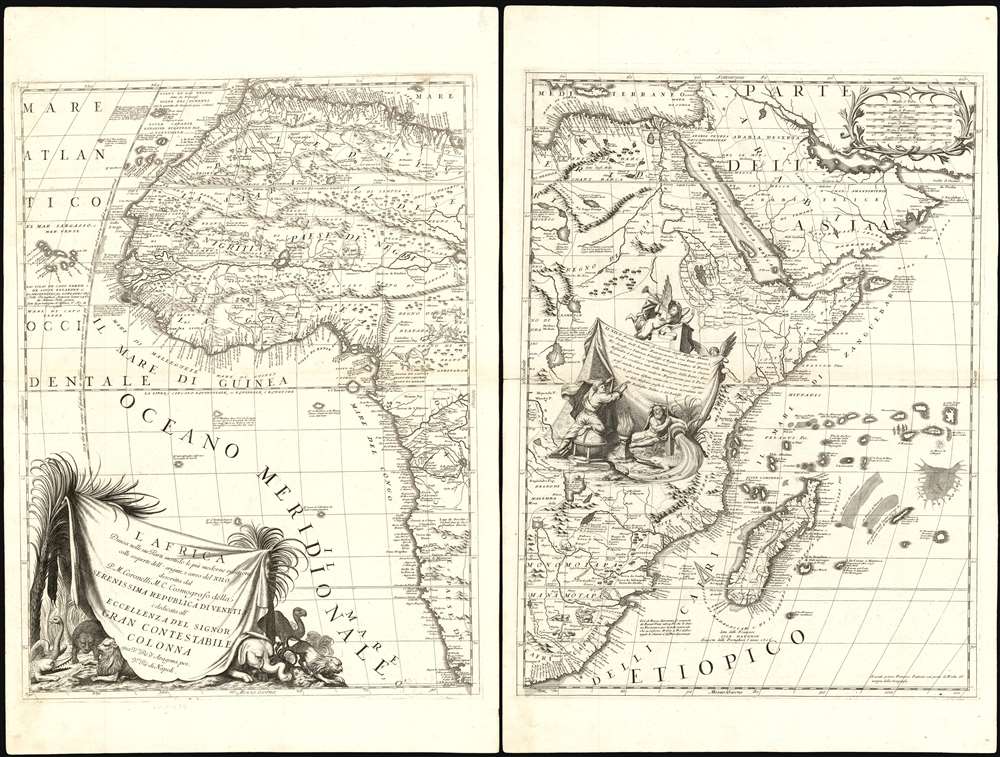
This is Vincenzo Maria Coronelli's magnificent 1691 two-sheet map of Africa: it is among the most distinctive maps ever printed of the continent, and one boldly presenting the groundbreaking revision of the mapping of the River Nile. The size of the map, as well as Coronelli's distinctive and elegant style, establish this map among the most sought-after antique maps of Africa. It is rich in historical detail, noting dates on which different regions were first reached by European explorers.
Coronelli's map is not the first to dispense with the long-cherished Ptolemaic Nile: the extremely rare four-sheet Du Val of 1678 has that honor; Coronelli's name is first associated with the new geographical model in the 1689 Coronelli-Nolin map of Africa, also separately-issued and extremely rare. Although these two maps pre-date the map appearing in Coronelli's 1691 Atlante Veneto, neither were as widely disseminated or seen as this one and consequently neither had as much impact.
Correcting the Course of the Nile (in increments)
Most maps of Africa produced in the sixteenth and seventeenth centuries showed the sources of the River Nile originating in two massive lakes - Zaire and Zaflan - well south of the Equator, and themselves fed by streams from the Mons Lunae. This formulation was inherited by European geographers from the ancient geographical authority, Claudius Ptolemy: hence the most enduring geographical feature of the African continent was derived from second century geographical knowledge. By far the most dramatic geographical change on Coronelli's map is the near excision of the lakes (only the southern portion of Lake Zaire is shown) and the eradication of the upper Nile, instead depicting Lake Tsana (Tana) in Abyssinia as the source of the great river. This represented a partial correction, Lake Tsana being the source of the Blue Nile. The White Nile (not retained on Coronelli's map) would remain mysterious until its true source was discovered by Waldecker in 1937.Coronelli's map is not the first to dispense with the long-cherished Ptolemaic Nile: the extremely rare four-sheet Du Val of 1678 has that honor; Coronelli's name is first associated with the new geographical model in the 1689 Coronelli-Nolin map of Africa, also separately-issued and extremely rare. Although these two maps pre-date the map appearing in Coronelli's 1691 Atlante Veneto, neither were as widely disseminated or seen as this one and consequently neither had as much impact.
The Lily, Gilded
Coronelli knew well the importance of this geographical change, and on this map he emphasized it with a dramatic cartouche. Coronelli's descriptive text is shown on a grand tapestry, suspended on the right by a putto and on the left hanging from the pinnacle of a Great Pyramid. A geographer - identified as such by the globe he uses as a footstool - points out the names of the scholar Hiob Ludolf and the Portuguese Jesuit Balthazar Tellez, two of the sources of the new information. A classical river god pours the river out of his jar, dousing a crocodile and threatening to inundate the geographer's maps and books. The winged, classical avatar of Fame hovers atop the scene, pointing out the new course of the Nile on the map, playing her vuvuzela.An Astonishing Menagerie
In addition to the crocodile in the descriptive cartouche, the title/dedicatory cartouche features lions, a camel, an ostrich... and another crocodile. The body of the map, however, is home to dozens of animals and monsters - some recognizable, some less familiar (apparently The Gambia River was thought to be home to giant hedgehogs, and the fabled Roc makes an appearance, carrying off a horse.)Publication History and Census
This desirable map appears on the market from time to time. Astonishingly, we see only one separate example catalogued in OCLC at the Bibliotheque National de France. The Atlante Veneto is reasonably well represented in institutional collections.Cartographer
Vincenzo Maria Coronelli (August 16, 1650 - December 9, 1718) was an important 17th-century cartographer and globe maker based in Venice. Coronelli was born the fifth child of a Venetian tailor. Unlikely to inherit his father's business, he instead apprenticed in Ravenna to a woodcut artist. Around 1663, Coronelli joined the Franciscan Order and, in 1671, entered the Venetian convent of Saint Maria Gloriosa dei Frari. Coronelli excelled in the fields of cosmography, mathematics, and geography. Although his works include the phenomenal Atlante Veneto and Corso Geografico, Coronelli is best known for his globes. In 1678, Coronelli was commissioned to make his first major globes by Ranuccio II Farnese, Duke of Parma. Each superbly engraved globe was five feet in diameter. Louis IV of France, having heard of the magnificent Parma globes, invited Coronelli to Paris, where from 1681-83 he constructed an even more impressive pair of globes measuring over 12 feet in diameter and weighing 2 tons each. The globes earned him the patronage of Louis XIV and privileged access to French cartographic information from Jesuit sources in the New World, particularly Louisiana. Coronelli returned to Venice and continued to publish globes, maps, and atlases, which were admired all over Europe for their beauty, accuracy, and detail. He had a particular fascination for the Great Lakes region, and his early maps of this area were unsurpassed in accuracy for nearly 100 years after their initial publication. He is also well known for his groundbreaking publication of the first accurate map depicting the sources of the Blue Nile. At the height of his career, Coronelli founded the world's first geographical society, the Accademia Cosmografica degli Argonauti, and was awarded the official title Cosmographer of the Republic of Venice. In 1699, in recognition of his extraordinary accomplishment and scholarship, Coronelli was also appointed Father General of the Franciscan Order. The great cartographer and globe maker died in Venice at the age of 68. His extraordinary globes can be seen today at the Bibliothèque Nationale François Mitterrand in Paris, Biblioteca Marciana in Venice, the National Library of Austria, the Globe Museum in Vienna, the Library of Stift Melk, the Special Collections Library of Texas Tech University, as well as lesser works in Trier, Prague, London, and Washington D.C. Coronelli's work is notable for its distinctive style, which is characterized by the high-quality white paper, dark intense impressions, detailed renderings of topographical features in profile, and numerous cartographic innovations. More by this mapmaker...
Source
Coronelli, V., Atlante Veneto, (Venice: Girolamo Albrizzi) 1697.
The Atlante Veneto was a Venetian cosmographic atlas issued by the Jesuit Minorite friar, geographer, and globe maker Vincenzo Maria Coronelli. The massive work consists of some 13 volumes in four parts. The first section focused on a general introduction to geography and included notes on various geographic systems and globes. The second part consisted of world maps from various periods and in various styles, including double-page maps of the continents and poles derived from his earlier globe work. The third part focused on hydrography and included nautically styled maps of important rivers, bays, oceans, lakes, and gulfs. The fourth and final section details exploration. The whole consisted of some 191 engraved charts and maps as well as an assortment of views and decorative plates. The atlas was conceived as a continuation of Blaeu's Atlas Major and, in many respects, follows Blaeu cartographically. Many of the other maps are derived from Coronelli's own earlier globe work and exhibit distinctly globe-like elements. Coronelli first issued the Atlante Veneto in 1691. A second edition was prepared and issued between 1695 and 1697. Most of the individual map plates remain identical and thus indistinguishable between editions. The maps of the Atlante Veneto are universally admired for their exquisite engraving and high production quality, including fine paper and premium inks. All examples were issued uncolored and have typically been left as such by dealers and collectors. Some of Coronelli's other works, including the Isolario dell' Atlante Veneto, Libro dei Globi, and Corso Geografico Universal, might reasonably considered amendments and expansions on the Atlante Veneto.
Condition
Very good condition. Small mend to fold of second sheet, else excellent with bold strikes. Size given above is for each printed image.
References
Betz, R., The Mapping of Africa A Cartobibliography of Printed Maps of the African Continent to 1700, 153.1 (First state, 1691). Tooley, MCS No. 47, p. 33. Norwich, O. I., Norwich's Maps of Africa: An Illustrated and Annotated Cartobibliography, 56. Rumsey 12186.000. OCLC 829499660.