This item has been sold, but you can get on the Waitlist to be notified if another example becomes available, or purchase a digital scan.
1852 Cruchley Map of Africa
Africa-cruchley-1853$75.00

Title
Africa.
1852 (dated) 15 x 18 in (38.1 x 45.72 cm) 1 : 25350000
1852 (dated) 15 x 18 in (38.1 x 45.72 cm) 1 : 25350000
Description
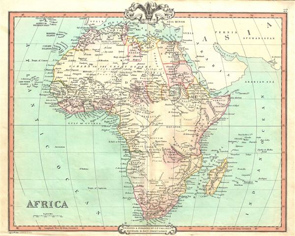
This is a beautiful 1852 map of Africa issued by George Frederick Cruchley. It details the continent of Africa, including Madagascar, on the cusp of the great exploratory expeditions of the mid-19th century undertaken by Speke, Livingstone, and Stanley. Though European colonies and outposts dot the coastlines, much of the interior remains unknown, even speculative. The speculative source of the Nile is shown to be somewhere south of the equator. Mt. Kilimanjaro and Mt. Kenya, first sighted by western explorers 1848 and 1849, are identified. Lake Malawi, near Mozambique, appears in embryonic form, no doubt drawn from indigenous and missionary reports, but gives some hint of the Great Rift Valley lakes soon to be discovered.
At the time this map was made, the slave trade, thriving since the 5th century was rapidly diminishing due to decreased demand for slaves in the New World, the British outlawing of slavery in 1808, and subsequent diplomatic efforts including treaties with over 50 African rulers outlawing the practice. Many African economies adapted by shifting to the export of mineral and agricultural resources, which led to the European scramble for territory, occupying most of the continent by the end of the 19th century. Europe's colonial interests in Africa haphazardly carved up the continent into unnatural territories, often forcing historic enemies into close proximity and leading to social problems that remain to this day.
Cruchley's General Atlas was unique for its period, employing a vivid color scheme extending even to the oceans, distinctive typography, and various uncommon decorative elements including a peacock feather crown and an imprint medallion, both of which break the printed border. Though many of the maps in this atlas are copyrighted in 1841, the atlas was first published in 1843 from the Cruchley office at 81 Fleet Street, London, and proving popular went through numerous reissues well into the 1850s.
Cartographer
George Frederick Cruchley (April 23, 1797 - June 16, 1880) was a London based book and map seller active in the middle part of the 19th century. Cruchley began his cartographic career as an apprentice at the venerable Aaroon Arrowsmith firm. Many of Cruchley's earliest maps bear the words 'From Arrowsmith's' on the imprint. In 1844, Cruchley acquired the massive stock of the important early 19th century firm of John Cary. Cruchley published his own maps as well as reissues of Cary's stock well into the 1870s. He is best known for his detailed plans of London, which in recent years have become increasingly scarce and desirable. Cruchley was based in London on 38 Ludgate Street until 1834 when he moved his offices to 81 Fleet Street. Shortly before his death in 1880 Cruchely auctioned (Hodgson's Auctions, Jan 16, 1877) his entire stock. Many of his map plates were thusly acquired by 'Gall and Inglis' who continued the Cruchley tradition well into the early 20th century. Cruchley's son, also George Frederick (1837 - 1882), continued to work as a book and map seller until his death. More by this mapmaker...
Source
Cruchley, G. F., Cruchley's General Atlas, for the use of Schools and Private Tuition, London, 1853.
Condition
Very good. Minor wear and verso repair along original centerfold. Blank on verso.