1631 Jansson / Hondius Map of Africa
Africa-jansson-1666$1,800.00

Title
Africae nova Tabula Auct. Hen. Hondio.
1666 (undated) 14.75 x 19.75 in (37.465 x 50.165 cm) 1 : 9000000
1666 (undated) 14.75 x 19.75 in (37.465 x 50.165 cm) 1 : 9000000
Description
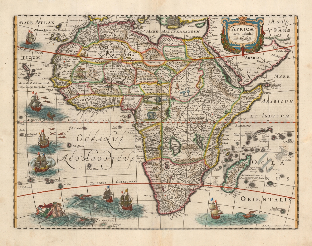
This is an attractive example of the Hondius map of Africa. It is a classic of Dutch decorative cartography. The map is embellished with lions, zebras, elephants, ostriches, and monkeys, while the oceans display seven sailing ships menaced by sea monsters. Flying fish skim the waters west of Guinea. A merman and mermaid embrace in the southern Atlantic - a recurring image in Hondius' maps (the identical couple appears in at least one other, Hondius' 1631 map of Italy.)
A Long-Lived and Influential Work
This map was originally engraved in 1619 by Jodocus Hondius Jr. as part of a set of four continent maps, and would appear in his brother Henricus Hondius' atlases starting in 1631. It replaced the map engraved by the elder Jodocus Hondius in 1606 - the earlier map had been based largely on the work of Gerard Mercator. Hondius' new map was derived from the 1617 Blaeu folio as well as the 1608 Blaeu wall map of Africa, but it was in turn widely copied: Bertius, Tavernier, Boisseau, and Berey all produced work based upon this map.A Closer Look
Hondius's cartography follows Blaeu's folio map both in terms of detail and execution: a wise choice emphasizing clarity and sharpness, presenting detail without sacrificing legibility. The coastline, in particular, is rich in toponomy, and the overall shape of the continent is remarkably accurate. Points within the continent, nonetheless, reveal the European ignorance of Africa's interior that would remain largely unchanged until well into the 19th century. The Nile, for example, is illustrated with its sources in the lakes of Zaire and Zaflan, an assumption inherited from no less venerable an authority than the 2nd-century Alexandrian geographer Claudius Ptolemy. The equally fictitious Lake Sachaf, derived from Laurent Fries' 1522 geography, appears in southern Africa, feeding the Zambere River, flowing to the Rio de Spirito Santo. The Cuama River is shown north of the Rio de Spirito Santo, but unlike earlier maps - including the 1608 Blaeu wall map - the Cuama is given its own source, instead of sharing a source at Lake Sachaf. The Niger River is shown running, essentially, in the wrong direction, emptying into the Senegal River, after having flowed from a supposed Lake Niger (a misunderstanding of the Niger inland delta?) in the general vicinity of what is now the Central African Republic. (The detailed mapping of the Niger River would not be complete until the 1890s.)Publication History and Census
This is the fifth state of Jodocus and Henricus Hondius' map. It was initially engraved in 1619. From the 1631 third state, it was included in the majority of the Hondius / Janssonius atlases. This particular example appeared in the 1666 edition of the Atlas Contractus. Thirteen examples of the separate map, in various editions but not this one, are cataloged in institutional collections. The 1666 Atlas Contractus is catalogued only in the Sachsische Landesbibliothek, Staatsbibliothek Zu Berlin, and the ULB Sachsen Anhalt Zentrale.CartographerS
Jan Jansson or Johannes Janssonius (1588 - 1664) was born in Arnhem, Holland. He was the son of a printer and bookseller and in 1612 married into the cartographically prominent Hondius family. Following his marriage he moved to Amsterdam where he worked as a book publisher. It was not until 1616 that Jansson produced his first maps, most of which were heavily influenced by Blaeu. In the mid 1630s Jansson partnered with his brother-in-law, Henricus Hondius, to produce his important work, the eleven volume Atlas Major. About this time, Jansson's name also begins to appear on Hondius reissues of notable Mercator/Hondius atlases. Jansson's last major work was his issue of the 1646 full edition of Jansson's English Country Maps. Following Jansson's death in 1664 the company was taken over by Jansson's brother-in-law Johannes Waesberger. Waesberger adopted the name of Jansonius and published a new Atlas Contractus in two volumes with Jansson's other son-in-law Elizée Weyerstraet with the imprint 'Joannis Janssonii haeredes' in 1666. These maps also refer to the firm of Janssonius-Waesbergius. The name of Moses Pitt, an English map publisher, was added to the Janssonius-Waesbergius imprint for maps printed in England for use in Pitt's English Atlas. More by this mapmaker...
Henricus Hondius II (1597 – August 16, 1651) was a Dutch engraver, cartographer and publisher. The son of the cartographer Jodocus Hondius, Henricus took over the business after father died in 1612, co-ran the business with his brother Jodocus II. In 1628 Henricus partnered with Jan Janssonius and together they continued the business, with Jansson’s name appearing on the Atlasas co-publisher after 1633. Eventually, about 50 editions of the Atlas were released in the main European languages. In the Islamic world, the atlas was partially translated by the Turkish scholar Katip Çelebi. The series is sometimes called the 'Mercator/Hondius/Jansson' series because of Jansson's later contributions. Learn More...
Source
Jansson, J., Atlas Contractus, (Amsterdam: Jansson) 1666.
Condition
Very good. Mended centerfold split with minor loss to border, not impacting map image.
References
Betz, R., The Mapping of Africa A Cartobibliography of Printed Maps of the African Continent to 1700, 58.3. Norwich, O. I., Norwich's Maps of Africa: An Illustrated and Annotated Cartobibliography, 34. Van der Krogt, P. C. J., Koeman's Atlantes Neerlandici, (3 Vols), 8600: 1D.4.