This item has been sold, but you can get on the Waitlist to be notified if another example becomes available, or purchase a digital scan.
1710 De La Feuille Map of Africa
Africa-lafeuille-1710$115.00

Title
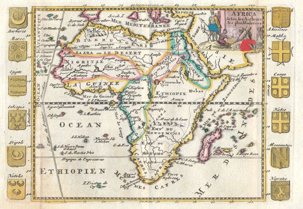
Africa Selon les Autheurs les plus Modernes.
1710 5.5 x 8 in (13.97 x 20.32 cm)
1710 5.5 x 8 in (13.97 x 20.32 cm)
Description
A very scarce, c. 1710, map of Africa by Daniel de la Feuille. Depicts the continent of Africa form an early 18th century perspective. The Niger River is mapped with surprising accuracy, especially considering its highly inaccurate mappings nearly 100 years later in the 19th century. The Mountains of the Moon, supposed source of the Nile, are located considerably south of where they appear in other maps of the period. Early Ptolemaic maps do note these mountains as well as two large lakes just to the north. Though the Mountains are present, both of these lakes are absent indicating an interesting evolution, away from the Ptolemaic conception, in African cartography. In southern Africa to large empires are named, Monoemugi and Monomotapa. This is the great southern African gold mining region and these names are likely taken from the names of prominent Congolese tribal rulers. Surrounding the map are the curious addition of twelve armorial crests. Crests include those of both Arab and African powers in the region including: Barbarie, Maroc (Morocco), Egypt, Tripoli, Notolie, Malta, Congo, Nubia, Monomotape, and Nigreitie. Many of these kingdoms and their associated armorial crests are purely conjectural. Ethiopia for example is indicated as distinct from Abyssinia with two separate crests, both unrelated to any actual crests that the kingdom seems to have used. The allegorical title cartouche in the upper right quadrant features several Africans cooking over a fire while an Impala or Antelope looks on. This map was originally prepared for inclusion as chart no. 5 in the 1702 edition of De la Feuille's Atlas Portatif. This map is from the later, 1710 edition.
Cartographer
Daniel de La Feuille (1640 - 1709) was born of Huguenot stock in Sedan (L'Ardennes), France. As a young man he apprenticed as a watchmaker. In 1663 La Feuille married Charlette Marlet, the daughter of a local carpenter. Twenty years later, in 1683, facing religious prosecution of Huguenots in France, the family fled to Amsterdam. By 1686 Daniel had become a burgher (citizen) of the city and established himself as an engraver, publisher, and art dealer. Not long after, in 1691, he was admitted into the Booksellers Guild. Though we are primarily concerned with his cartographic work here, his masterpiece is considered to be Devises et emblems, a collection of symbols and designs mostly likely intended as templates for silversmiths, engravers, and watchmakers. His cartographic work includes numerous individual maps and atlases, many of which continued to be published and republished well after his death in 1709. He was succeeded by his sons Jacob de la Feuille (1668 - 1719) and Paul de La Feuille (1688 - 1727). More by this mapmaker...
Condition
Very Good condition. Minor discoloration along the original folds – see photo. Minor fold separation limited to wide marginal region. Original plate-mark visible. Else clean and beautiful.