
This item below is out of stock, but another example (left) is available. To view the available item, click "Details."
Details
1848 Levasseur Map of Senegal, Gambia and Madagascar
1848 (undated) $175.00
1847 Levasseur Map of Africa
Africa-levasseur-1847$100.00

Title
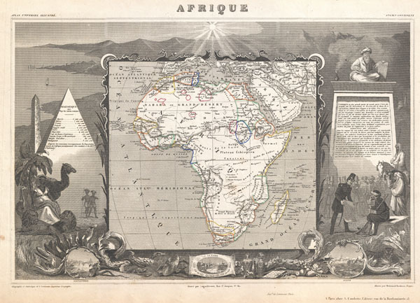
Afrique.
c. 1847 (undated) 12.5 x 18 in (31.75 x 45.72 cm)
c. 1847 (undated) 12.5 x 18 in (31.75 x 45.72 cm)
Description
A stunning c. 1847 map of Africa by French cartographer Victor Levasseur. Depicts the entire continent with several interesting elements. A large lake appears in Mozambique which can only be Lake Malawi (Lake Nyasa). Lake Chad (Tchad) is also shown. Names numerous African kingdoms including Monomotapa and the Hottentots. Surrounded by the elaborate borders for which Levasseur is best known. Shows a stylized pyramid and obelisk, an imam, a French soldier consulting with Arabs, and three city vies: Alexandria, Cairo and Algiers. Prepared and published for V. Levasseur's magnificent c. 1847 Atlas Universel Illustre, one of the last decorative atlases of the 19th century.
Cartographer
Victor Levasseur (1800 - 1870), an important French engineer, cartographer, and engraver of the mid 19th century, held a number of important cartographically related political and educations posts in France. He is most famous for his Atlas National Illustré des 86 Départements et des Possessions de La France, a large decorative atlas of France, including his Planisphere and five important continental maps. Levasseur's maps are distinctive for their wide decorative margins containing elaborate depictions of the scenery, peoples, and trade goods of the areas he mapped. Levasseur maps are also known to offer a wealth of statistical data. Until recently, very few Levasseur Atlases migrated out of France where they were mostly used in public libraries and town halls. His work represents some of the last great decorative atlases of the 19th century. More by this mapmaker...
Source
Levasseur, V., Atlas Universel Illustre, c. 1847.
Condition
Very good. Light overall toning. Blank on verso.
References
Rumsey 0427.094. Phillips (Atlases) 3003.