
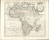
1705 Pierre Moullart-Sanson Map of Africa

This item has been sold.
L'Afrique divisée en ses Principales Parties ou les Empires les Monarchies les Royaumes les Etats et les Peuples sont distingues les uns des autres Par les Srs. Sanson Geographes ordinres. du Roi.
Extremely Rare Sanson Family Map of Africa, Updated.
- Digital Map Information
- Suitable for large format printing
- Full resolution TIFF file
- ICC color profile embedded
- Delivered instantly via download link
Extremely Rare Sanson Family Map of Africa, Updated.
This large, rare map is the 1705 map of Africa by Pierre Moulart-Sanson, Nicolas Sanson's grandson and cousin of Guillaume Sanson. While one of the family's last folio maps, it is among the most distinctive for its incorporation of contemporary developments in African geography, making it the first new mapping of Africa embraced by the Sansons since the mid-17th century.A Closer Look
Coverage embraces Africa from the Cape Verde Islands in the west to the island of Socotra off Cape Horn, and the atoll of Saint-Francois in the Seychelles. The Mediterranean Sea and part of southern Europe appear at the top; it extends as far south as 37ºS, showing the Island of Tristan da Cunha. The map is composed in the style typified by the Sanson' family's work: clear lines and elegant design with minimal ornament, and hand color applied to enhance comprehension of the map rather than to decorate. In the upper right is a garlanded cartouche topped with an ostrich feather crown. The composition of the cartouche reveals an uncharacteristic slip: the text is slightly oversized for the space afforded by the decorative engraving, thus partly overlapping the border.This map stands in sharp contrast to Pedley's observation that 'Sanson's heirs had been content to republish his work without further corrections.' While Moullart-Sanson was not unlike his predecessors in this respect, he did produce new matter from time to time. Although he acquired a great many of the copperplates of the family firm, Sanson's erstwhile partner, Mariette, retained others. Moullart-Sanson, then, had to engrave new maps to fill those gaps, including the present work.
Moullart-Sanson's map is more square than the older Sanson, being approximately 2 inches taller and narrower, thus focusing more exclusively on Africa. Nicolas Sanson's 1650 map reached further west, revealing part of the coast of Brazil, and further east, to include the 'Three Brothers' of the Seychelles. Moullart-Sanson's change in scope thus presents a larger, more focused, and legible Africa.
The Sanson firm's mapping of Africa long adhered to the conventions of contemporary Dutch mapmakers. Aesthetically, the new French maps were noted for their austerity, and for the first steps towards the positivist approach which would characterize the maps of De l'Isle and Robert de Vaugondy. Sanson's maps, too, improved on the mapping of those areas with which the French were familiar. For example, the Guinea coast from Sierra Leone to Benin is here sharply different from Dutch maps of the period. This map also excludes the Ptolemaic lakes feeding the Nile that dominated 16th and 17th-century maps of the continent. The source of the Blue Nile is here depicted correctly after the 1683 Lufolf map.
In some cases, the sources for the improvements came from within the Sanson oeuvre. The mapping of Western Africa - Guinea, and the regions of Morocco and Fez in particular - is sharply improved over the 1650 general map of Africa. This detail can be traced to Sanson's own particular maps of those regions. South Africa, however, is here treated very differently from either the 1650 general map or the later Sanson maps. The river system opening near Sofala is completely absent on Sanson's earlier maps. It is close, but not identical to the treatment of that area on Guillaume De l'Isle's Carte du Congo et du Pays des Cafres. Further south, while retaining the Rio de Infante from earlier Sanson maps, Moullart-Sanson added a winding tributary corresponding to a Rivier Sans Fin pictured on De l'Isle's maps. Another element likely drawn from De l'Isle's maps is Moullart-Sanson's depiction and description of the Sargasso Sea, both between the Cape Verde Islands and the Azores, and to the west of southern Africa south of St. Helena.
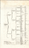
The Geographical Table
Among Nicolas Sanson's innovations were his popular geographical tables. These logic tables categorized and ranked geographical areas and their subordinate parts in a clear format. By presenting continents, their broader regions, and the subdivision of those regions into kingdoms, principalities, and cities, these tables assisted in the memorization of those placenames and their conceptual relationships to one another. They were intended also for use independently of the maps: the title of the separate volume of tables touted them asA Method for Easily Acquiring Knowledge of Geography, and for Identifying the Empires, Monarchies, Kingdoms, States, Republics, and Peoples - both Ancient and Modern - of All Parts of the World; Showing into How Many Specific Regions or Provinces They Are Subdivided, and Which Are Their Most Notable Cities.Sanson's atlases included these tables, and his son Guillaume retained them, as did Moullart-Sanson.
Publication History and Census
This map was engraved for inclusion in Pierre Moullart-Sanson's atlases and is dated 1705. It remained in his Introduction à la géographie en plusieurs cartes avec leur explication and his Cartes et tables de la géographie ancienne et nouvelle thereafter, also appearing in examples of the atlases issued after 1730, when the firm passed to Gilles Robert de Vaugondy. We have identified no change in the plate until the map was freshly re-engraved in 1741 by Vaugondy, with significant compositional changes. The map is extremely rare, and we have located only one example at the Bibliothèque nationale de France.Cartographer
Nicolas Sanson (December 20, 1600 - July 7, 1667) and his descendants were the most influential French cartographers of the 17th century and laid the groundwork for the Golden Age of French Cartography. Sanson was born in Picardy, but his family was of Scottish Descent. He studied with the Jesuit Fathers at Amiens. Sanson started his career as a historian where, it is said, he turned to cartography as a way to illustrate his historical studies. In the course of his research some of his fine maps came to the attention of King Louis XIII who, admiring the quality of his work, appointed Sanson Geographe Ordinaire du Roi. Sanson's duties in this coveted position included advising the king on matters of geography and compiling the royal cartographic archive. In 1644, he partnered with Pierre Mariette, an established print dealer and engraver, whose business savvy and ready capital enabled Sanson to publish an enormous quantity of maps. Sanson's corpus of some three hundred maps initiated the golden age of French mapmaking and he is considered the 'Father of French Cartography.' His work is distinguished as being the first of the 'Positivist Cartographers,' a primarily French school of cartography that valued scientific observation over historical cartographic conventions. The practice result of the is less embellishment of geographical imagery, as was common in the Dutch Golden Age maps of the 16th century, in favor of conventionalized cartographic representational modes. Sanson is most admired for his construction of the magnificent atlas Cartes Generales de Toutes les Parties du Monde. Sanson's maps of North America, Amerique Septentrionale (1650), Le Nouveau Mexique et La Floride (1656), and La Canada ou Nouvelle France (1656) are exceptionally notable for their important contributions to the cartographic perceptions of the New World. Both maps utilize the discoveries of important French missionaries and are among the first published maps to show the Great Lakes in recognizable form. Sanson was also an active proponent of the insular California theory, wherein it was speculated that California was an island rather than a peninsula. After his death, Sanson's maps were frequently republished, without updates, by his sons, Guillaume (1633 - 1703) and Adrien Sanson (1639 - 1718). Even so, Sanson's true cartographic legacy as a 'positivist geographer' was carried on by others, including Alexis-Hubert Jaillot, Guillaume De L'Isle, Gilles Robert de Vaugondy, and Pierre Duval. Further Details...
Source
Moulart-Sanson, Pierre, Cartes et tables de la géographie ancienne et nouvelle., (Paris: Sanson) 1705 - 1740.
Condition
Very good. Waterstaining at top margin, entering printed area. Marginal mends at top with no impact to printed image; bottom centerfold reinforced. Original outline color. Table page separate but present.
References
OCLC 1447421496. Text sheet: see Rumsey 9741.009.